Atlantic Beach in Carteret County, North Carolina — The American South (South Atlantic)
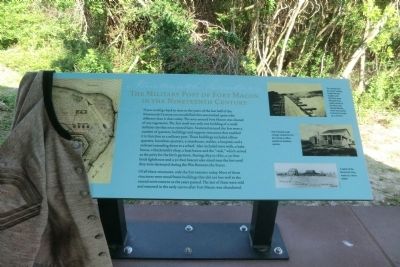
The Military Post of Fort Macon in the Nineteenth Century
Inscription.
If you could go back in time to the years of the last half of the Nineteenth Century you would find this area looked quite a bit different than it does today. The area around Fort Macon was cleared of any vegetation. The fort itself was only one building of a small military city that once existed here. Scattered around the fort were a number of quarters, buildings and support structures that enabled it to function as a military post. These building included officer quarters, laundress quarters, a storehouse, stables, a hospital, and a railroad extending down to the wharf. Also included were wells, a bake house, a blacksmith’s shop, a boat house and the “sink,” which served as the privy for the fort’s garrison. During 1855 to 1862, a 50-foot brick lighthouse and a 30-foot beacon also stood near the fort until they were destroyed during the War Between the States.
Of all these structures, only the fort remains today. Most of these structures were wood frame buildings that did not fare well in the coastal environment as the years passed. The last of them were sold as removed in the early 1900s after Fort Macon was abandoned.
(captions)
(upper right) The railroad from the wharf, looking toward the fort. Supplies and munitions were offloaded from supply vessels at the wharf onto railroad flatcars, which were pulled by horses or mules up to the fort.
(center right) One of several small cottages outside the fort that served as officer quarters or laundress quarters.
(lower right) A sketch of the Blacksmith Shop made by a Union soldier.
Topics. This historical marker is listed in these topic lists: Forts and Castles • War, US Civil. A significant historical year for this entry is 1855.
Location. 34° 41.84′ N, 76° 40.724′ W. Marker is in Atlantic Beach, North Carolina, in Carteret County. Marker can be reached from East Fort Macon Road (County Route 1190) 3.6 miles east of Atlantic Beach Causeway (County Route 1182). The marker is on the grounds of the Fort Macon State Park. Touch for map. Marker is at or near this postal address: 2303 East Fort Macon Road, Atlantic Beach NC 28512, United States of America. Touch for directions.
Other nearby markers. At least 8 other markers are within walking distance of this marker. Fort Macon in the 1920s and 1930s (here, next to this marker); World War II Barracks Area (here, next to this marker); World War II Defenses (a few steps from this marker); Fort Macon Coast Guard Station (a few steps from this marker); Officers Quarters at Fort Macon (within shouting distance of this marker); 30-Pounder Parrott Rifle (within shouting distance of this marker); Fort Macon (within shouting distance
of this marker); Bogue Banks Lighthouse (within shouting distance of this marker). Touch for a list and map of all markers in Atlantic Beach.
Also see . . . Fort Macon State Park. N.C. Division of Parks & Recreation (Submitted on September 15, 2014.)
Credits. This page was last revised on June 16, 2016. It was originally submitted on September 12, 2014, by Don Morfe of Baltimore, Maryland. This page has been viewed 313 times since then and 6 times this year. Photos: 1, 2. submitted on September 12, 2014, by Don Morfe of Baltimore, Maryland. • Bernard Fisher was the editor who published this page.

