Atlantic Beach in Carteret County, North Carolina — The American South (South Atlantic)
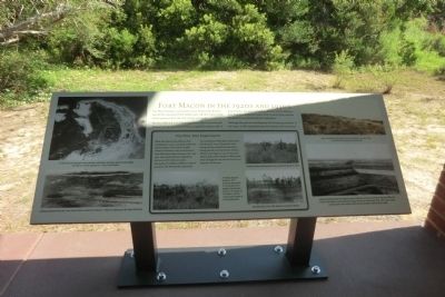
Fort Macon in the 1920s and 1930s
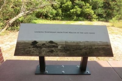
The fort itself, and a US Lifesaving Service (later Coast Guard) Station built in 1904, were all that occupied the eastern end of Bogue Banks. The area surrounding the fort was far different then from how it appears today. Then, it was all open savanna bordered by marshland and low sand dunes.
Although the park saw development and increasing visitation in the 1930s, it still retained this pastoral character for many years.
(sidebar
The Pine Tree Experiment
When Fort Macon State Park was first established in 1924, it was placed under the administration of the North Carolina Division of Forestry, since no Division of State Parks then existed. Between 1927 and 1930, the Forestry Division utilized the land around Fort Macon to plant thousands of seedlings of different types of pine trees. The reforestation experiment was to determine which types of pine grew best along the coast. The growth of the young trees was studied and monitored during periodic visits by Forestry Division officials until August 3, 1932. At that time, careless park visitors started a wild fire that swept through the area around the fort and destroyed all the trees.
(clockwise) Forestry workers planting pine trees around Fort Macon in 1929.; The aftermath of the 1932 wild fire around Fort Macon; A forestry Division worker in 1931 assessing the growth of young pine trees planted several years earlier on the slope of Fort Macon. The US Coast Guard Station is in the background.
(captions)
(upper left) A 1933 aerial photograph shows marshes, sand dunes and open grounds surrounding Fort Macon and the adjacent U.S. Coast Guard Station.
(lower left) Looking eastward from the Coast Guard Station toward Fort Macon—sheep are grazing on the slope of the fort.
(upper right) Open grounds look eastward from Fort Macon in the late 1920s. The present-day parking lot was built here.
(lower right) Looking northward from Fort Macon across marshland and open savanna in the late 1930s. The house in the distance was the Nicoll Cottage, which was used during 1936-1941 as the park’s vacation cabin. Park visitors could rent the furnished cabin for $20 a week.
Topics. This historical marker is listed in these topic lists: Forts and Castles • Horticulture & Forestry. A significant historical year for this entry is 1924.
Location. 34° 41.843′ N, 76° 40.721′ W. Marker is in Atlantic Beach, North Carolina, in Carteret County. Marker can be reached from East Fort Macon Road (County Route 1190) 3.6 miles east of Atlantic Beach Causeway (County Route 1182). The marker is on the grounds of Fort Macon State Park. Touch for map. Marker is at or near this postal address: 2303 East Fort Macon Road, Atlantic Beach NC 28512, United States of America. Touch for directions.
Other nearby markers. At least 8 other markers are within walking distance of this marker. The Military Post of Fort Macon in the Nineteenth Century (here, next to this marker); World War II Defenses (here, next to this marker); Fort Macon Coast Guard Station (a few steps from this marker); World War II Barracks Area (a few steps from this marker); Officers Quarters at Fort Macon (within shouting distance of this marker); 30-Pounder Parrott Rifle (within shouting distance of this marker); Fort Macon (within shouting distance of this marker); Bogue Banks Lighthouse (within shouting distance of this marker). Touch for a list and map of all markers in Atlantic Beach.
Also see . . . Fort Macon State Park. N.C. Division of Parks & Recreation (Submitted on September 15, 2014.)
Credits. This page was last revised on June 16, 2016. It was originally submitted on September 12, 2014, by Don Morfe of Baltimore, Maryland. This page has been viewed 367 times since then and 15 times this year. Photos: 1, 2. submitted on September 12, 2014, by Don Morfe of Baltimore, Maryland. • Bernard Fisher was the editor who published this page.

