Marker Logo HMdb.org THE HISTORICAL
MARKER DATABASE
“Bite-Size Bits of Local, National, and Global History”
La Porte in LaPorte County, Indiana — The American Midwest (Great Lakes)
 

Indian Boundary Line


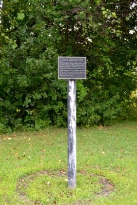
Indian Boundary Line Marker image. Click for full size.
Photographed By Duane Hall, August 16, 2014
1. Indian Boundary Line Marker
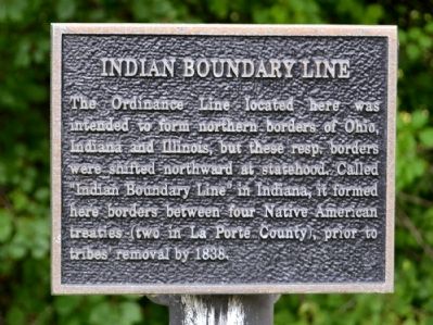
Inscription. The Ordinance Line located here was intended to form northern borders of Ohio, Indiana and Illinois, but these resp. borders were shifted northward at statehood. Called “Indian Boundary Line” in Indiana, it formed here borders between four Native American treaties (two in La Porte County), prior to tribes’ removal by 1838.
 
Topics. This historical marker is listed in these topic lists: Native AmericansSettlements & Settlers. A significant historical year for this entry is 1838.
 
Location. 41° 37.006′ N, 86° 44.391′ W. Marker is in La Porte, Indiana, in LaPorte County. Marker is on Grangemouth Road, 0.1 miles north of Lake Shore Drive, on the right when traveling north. Marker is located in Soldiers Memorial Park across from the parking lot entrance to Stone Lake Beach. Touch for map. Marker is in this post office area: La Porte IN 46350, United States of America. Touch for directions.
 
Other nearby markers. At least 8 other markers are within walking distance of this marker. La Porte World War II Memorial (approx. ¼ mile away); Memorial Forest Planting (approx. ¼ mile away); La Porte World War II Memorial (1991) (approx. ¼ mile away); La Porte Korean War Memorial (approx. ¼ mile away); La Porte County Afghanistan–Iraq–Kuwait Memorial (approx. ¼ mile away); La Porte Viet Nam Memorial (approx. ¼ mile
Paid Advertisement
Click on the ad for more information.
Please report objectionable advertising to the Editor.
Click or scan to see
this page online
away); Operation Desert Storm Memorial (approx. ¼ mile away); Indiana Territory Boundary Line (approx. 0.4 miles away). Touch for a list and map of all markers in La Porte.
 
Additional commentary.
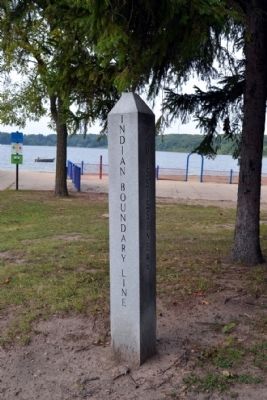
1. Boundary Line Stone Obelisk
Located 250 feet west of the Indian Boundary Line marker is a recently installed stone obelisk. This obelisk demarcates the boundary between the lands of the Treaty of Mississinewa (1826) to the north and the lands of the Treaty of Tippecanoe (1832) to the south. The east-west line between the Indian Boundary Line marker and the stone obelisk is the boundary line described in the marker.
    — Submitted September 18, 2014, by Duane Hall of Abilene, Texas.
 
Indian Boundary Line Marker image. Click for full size.
Photographed By Duane Hall, August 16, 2014
2. Indian Boundary Line Marker
Indian Boundary Line Marker image. Click for full size.
Photographed By Duane Hall, August 16, 2014
3. Indian Boundary Line Marker
Marker is located on the opposite side of the road across from the entrance to Stone Lake Beach.
Boundary Line Stone Obelisk image. Click for full size.
Photographed By Duane Hall, August 16, 2014
4. Boundary Line Stone Obelisk
Inscribed on the faces of the obelisk are Treaty of Mississinewa (north face), Ordinance Line (west face), Treaty of Tippecanoe (south face), and Indian Boundary Line (east face)
Indian Boundary Line image. Click for full size.
Photographed By Duane Hall, August 16, 2014
5. Indian Boundary Line
View from marker to stone obelisk (located behind boulder next to street lamp); the east-west line between the marker and obelisk is the boundary line described in the marker
Indian Boundary Line image. Click for full size.
Photographed By Duane Hall, August 16, 2014
6. Indian Boundary Line
View from stone obelisk; marker is located behind the street lamp
 
 
Credits. This page was last revised on June 16, 2016. It was originally submitted on September 18, 2014, by Duane Hall of Abilene, Texas. This page has been viewed 1,230 times since then and 76 times this year. Photos:   1, 2, 3, 4, 5, 6. submitted on September 18, 2014, by Duane Hall of Abilene, Texas.
Share this page.  
Share on Tumblr
m=77262

CeraNet Cloud Computing sponsors the Historical Marker Database.
This website earns income from purchases you make after using our links to Amazon.com. We appreciate your support.
Paid Advertisement
Apr. 19, 2024