Southwest Raleigh in Wake County, North Carolina — The American South (South Atlantic)
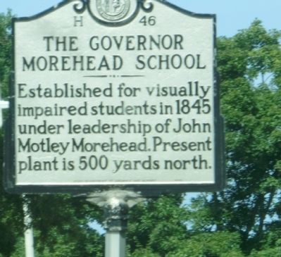
The Governor Morehead School
Erected 1949 by State Department of Archives and History. (Marker Number H-46.)
Topics and series. This historical marker is listed in this topic list: Education. In addition, it is included in the North Carolina Division of Archives and History series list. A significant historical year for this entry is 1845.
Location. 35° 46.72′ N, 78° 39.83′ W. Marker is in Raleigh, North Carolina, in Wake County. It is in Southwest Raleigh. Marker is at the intersection of Western Boulevard and Ashe Avenue, on the right when traveling west on Western Boulevard. Touch for map. Marker is at or near this postal address: 520 Ashe Avenue, Raleigh NC 27606, United States of America. Touch for directions.
Other nearby markers. At least 8 other markers are within walking distance of this marker. State School for the Blind (approx. ¼ mile away); The First People (approx. 0.4 miles away); Spring Hill (approx. 0.4 miles away); Dix Hospital Cemetery (approx. 0.4 miles away); Memorial Belltower (approx. half a mile away); Camp Bryan Grimes (approx. half a mile away); Central Prison (approx. half a mile away); North Carolina State University at Raleigh (approx. half a mile away). Touch for a list and map of all markers in Raleigh.
Also see . . . The Governor Morehead School. (Submitted on October 8, 2014.)
Credits. This page was last revised on February 16, 2023. It was originally submitted on October 7, 2014, by Don Morfe of Baltimore, Maryland. This page has been viewed 317 times since then and 13 times this year. Photo 1. submitted on October 7, 2014, by Don Morfe of Baltimore, Maryland. • Bernard Fisher was the editor who published this page.
