Near Bolivar in Jefferson County, West Virginia — The American South (Appalachia)
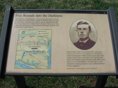
Five Rounds into the Darkness
Harpers Ferry National Historical Park
— National Park Service, U.S. Department of the Interior —
"Sharp musketry began on our extreme left, it came rapidly toward us and soon we to were blazing away. We fired five rounds into the darkness. When the firing ceased and no body seemed to know what was the matter it was said that the Reble Cavalry had attempted to pass between us and a Hill beyond. This was our second Sunday in the field and we easily reached the conclusion that there was no sabbath laid down in Army regulations."
Sergeant Nicholas J. DeGraff, Company D, 115th New York Regiment
Erected by National Park Service, U.S. Department of the Interior.
Topics. This historical marker is listed in this topic list: War, US Civil.
Location. 39° 19.596′ N, 77° 45.931′ W. Marker is near Bolivar, West Virginia, in Jefferson County. Marker is on Bakerton Road (County Road 27), on the right when traveling north. Located along the Union Skirmish Line Trail, in Harpers Ferry National Historic Park. Touch for map. Marker is in this post office area: Harpers Ferry WV 25425, United States of America. Touch for directions.
Other nearby markers. At least 8 other markers are within walking distance of this marker. Union Skirmish Line (about 500 feet away, measured in a direct line); Battle of Harpers Ferry / Jackson Arrives (about 600 feet away); School House Ridge, Harpers Ferry, W.V. (about 700 feet away); The Confederate Perspective (about 700 feet away); We Began Firing At Will: The 111th New York Regiment (about 700 feet away); From Skirmish Line to Burial Ground (approx. 0.2 miles away); A Position Strong by Nature (approx. ¼ mile away); A Dangerous Position (approx. 0.3 miles away). Touch for a list and map of all markers in Bolivar.
More about this marker. On the lower left of the marker is a map detailing the tactical situation described in the text. On the right is a portrait of Sergeant DeGraff.
Also see . . . 1862 Battle of Harpers Ferry. National Park Service summary of the battle. (Submitted on May 19, 2008, by Craig Swain of Leesburg, Virginia.)
Credits. This page was last revised on July 6, 2020. It was originally submitted on May 19, 2008, by Craig Swain of Leesburg, Virginia. This page has been viewed 1,132 times since then and 15 times this year. Photos: 1, 2, 3, 4. submitted on May 19, 2008, by Craig Swain of Leesburg, Virginia.


