Annapolis Royal in Annapolis County, Nova Scotia — The Atlantic Provinces (North America)
Sieur de Monts
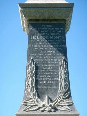
Sieur de Monts,
the pioneer of civilization in North America, who discovered and explored the adjacent river, A.D. 1604, and founded on its banks the first settlement of Europeans north of the Gulf of Mexico.
The government of Canada reverently dedicates this monument within sight of that settlement, A.D, 1904.
Erected 1904 by Government of Canada / Gouvernement du Canada.
Topics and series. This historical marker is listed in these topic lists: Exploration • Settlements & Settlers. In addition, it is included in the Acadian History series list. A significant historical year for this entry is 1604.
Location. 44° 44.545′ N, 65° 31.16′ W. Marker is in Annapolis Royal, Nova Scotia, in Annapolis County. Marker can be reached from St. George Street close to St. Anthony Street, on the left. Touch for map. Marker is at or near this postal address: 323 St George Street, Annapolis Royal NS B0S, Canada. Touch for directions.
Other nearby markers. At least 8 other markers are within walking distance of this marker. Queen’s Wharf (within shouting distance of this marker); William Wolseley (within shouting distance of this marker); Port-Royal (within shouting distance of this marker); Masonic Stone of 1606 (within shouting distance of this marker); The Black Hole / Le cachot (about 90 meters away, measured in a direct line); The Flag Bastion (about 90 meters away); Daniel Auger de Subercase (about 120 meters away); Captures of Port Royal (about 120 meters away). Touch for a list and map of all markers in Annapolis Royal.
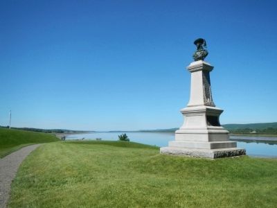
More about this marker. This marker is located on the grounds of Fort Anne National Historic Site.
Also see . . . Pierre du Gua de Monts - Dictionary of Canadian Biography. Despite the tremendous contribution made by this far-seeing and broadminded individual to the development of Canada, he has seldom been accorded his rightful place in accounts of its history. Here is the man who made possible so much of what Champlain accomplished. (Submitted on November 1, 2014, by Barry Swackhamer of Brentwood, California.)
Credits. This page was last revised on June 16, 2016. It was originally submitted on November 1, 2014, by Barry Swackhamer of Brentwood, California. This page has been viewed 449 times since then and 9 times this year. Photos: 1, 2. submitted on November 1, 2014, by Barry Swackhamer of Brentwood, California. 3. submitted on November 1, 2014. • Andrew Ruppenstein was the editor who published this page.


