Frederick in Frederick County, Maryland — The American Northeast (Mid-Atlantic)
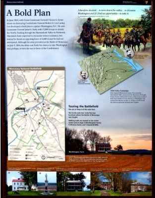
A Bold Plan
Topics. This historical marker is listed in this topic list: War, US Civil. A significant historical month for this entry is June 1864.
Location. This marker has been replaced by another marker nearby. It was located near 39° 22.631′ N, 77° 23.718′ W. Marker was in Frederick, Maryland, in Frederick County. Marker could be reached from New Technology Way, 0.1 miles east of Urbana Pike (Maryland Route 355), on the right when traveling east. Touch for map. Marker was at or near this postal address: Monocacy National Battlefield Visitor Center, Frederick MD 21704, United States of America. Touch for directions.
Other nearby markers. At least 8 other markers are within walking distance of this location. A different marker also named A Bold Plan (a few steps from this marker); Battle Begins (a few steps from this marker); The Lost Order (within shouting distance of this marker); 1862 Antietam Campaign (within shouting distance of this marker); Monocacy Battlefield (within shouting distance of this marker); This Boulder Overlooks the Monocacy Battlefield (about 600 feet away, measured in a direct line); Battle of Monocacy (about 600 feet away); Headquarters of Generals Robert E. Lee, "Stonewall" Jackson and Longstreet Sept. 6-9, 1862. (about 600 feet away). Touch for a list and map of all markers in Frederick.
More about this marker. Marker was formerly located at 39.361659N 77.401715W, down a long driveway off of Baker Valley Road just east of its underpass of I-270.
Related marker. Click here for another marker that is related to this marker. This marker has been replaced with the linked marker which has different text.
Credits. This page was last revised on January 7, 2023. It was originally submitted on November 4, 2014, by Allen C. Browne of Silver Spring, Maryland. This page has been viewed 618 times since then and 9 times this year. Photos: 1, 2. submitted on November 4, 2014, by Allen C. Browne of Silver Spring, Maryland. 3. submitted on July 24, 2016, by William Fischer, Jr. of Scranton, Pennsylvania. • Bill Pfingsten was the editor who published this page.


