Annapolis Royal in Annapolis County, Nova Scotia — The Atlantic Provinces (North America)
Wharf & Waterfront
Historic Lower Saint George Street

Photographed By Barry Swackhamer, June 17, 2014
1. Wharf & Waterfront Marker
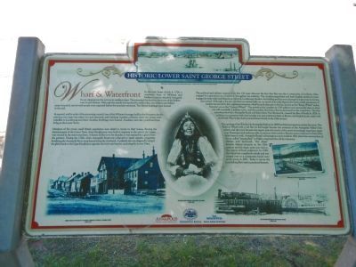
Captions: (top) Watercolour of Annapolis Royal (detail) painted by Capt. J. Hamilton, 1753.; (left to right) Image taken at the head of the wharf looking up Lower St. George Street, circa 1875.; Mi’kmaq elder wearing traditional clothing, circa 1889.; The steamer Empress at the railway wharf, circa 1889.; Postcard of the railway wharf in Granville Ferry, circa 1919.
In reprisal, and by order of the governing council, one of the Mi’kmaw hostages held in the fort prison for the previous two years was taken out and executed; and claiming Acadian collusion, their two priests were expelled to Louisbourg and three Acadian dwellings were burned. Acadians were also prohibited from living in the Lower Town.
Members of the town’s small British population were afraid to return to their homes. Fearing the abandonment of the Lower Town, three blockhouses were built in response to the attack; the largest was erected in the street near here. A fixture in the town for decades, it was manned by a guard from the garrison. During the 1740s, when Annapolis Royal was subjected to yearly assaults, properties bordering the Annapolis River were fenced along the riverbank. A palisade also ran diagonally behind the glebe lands to the Cape blockhouse opposite the fort’s east bastion, enclosing the Lower Town.
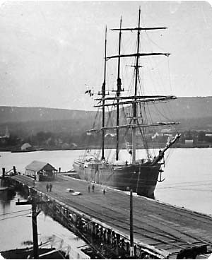
The political and military turmoil of its first 150 years obscures the fact that this was also a community of civilians, often engaged in a precarious act of survival. Smuggling was endemic. The Acadian population and early English settlers in town engaged in trade with both Boston and its rival, Louisbourg. Feathers for bedding and hay were among the major exports during that period. Although a few private wharves existed early on, for much of its early history, the town’s small population of traders was served by the original government wharf located adjacent to the fort, known as the “King’s Wharf” and in Victoria’s era as the “Queen’s Wharf”. The arrival of the Loyalists in 1783 added a new mercantile class to what was still essentially a military town, and the number of private wharves increased on the waterfront. The first steamboat between Annapolis Royal and Saint John, New Brunswick, crossed the Bay of Fundy in 1826. In addition to commerce with that Loyalist city and traditional links to Boston and English ports, trade with the British West Indies had increased dramatically in the 19th century.
The opening of the Windsor & Annapolis Railway in 1869 heralded a prosperous era for the town. The Railway Wharf with a rail line its full length became the terminus of the Annapolis Valley’s
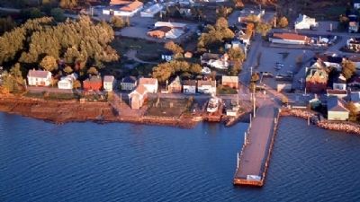
first railway and the town became the export point for much of the area’s increasingly important apple crop. Passengers and mail were able to connect with vessels to Boston once a week and to Saint John three times a week. Annapolis Royal’s advantage as a port ended in 1891 when the construction of the so-called “missing link” to Digby completed the rail line between Halifax and Yarmouth. The wharf became federal property in the 20th century and for many years was vital to the export of local pulpwood. In 1988, the wharf was completely rebuilt and was turned over to a community based non-profit group in 2001. Today it serves the local fishing fleet and recreational boaters.
Erected by Annapolis Heritage Society, Annapolis Royal National Historic District & Province of Nova Scotia.
Topics and series. This historical marker is listed in these topic lists: Native Americans • Railroads & Streetcars • Waterways & Vessels. In addition, it is included in the Acadian History series list. A significant historical date for this entry is July 4, 1982.
Location. 44° 44.744′ N, 65° 31.134′ W. Marker is in Annapolis Royal, Nova Scotia, in Annapolis County. Marker is at the intersection of St. George Street and Drury Lane, on the right when traveling north on St. George Street. Touch for map. Marker is at or near this postal address: 198 St George Street, Annapolis Royal NS B0S, Canada. Touch for directions.
Other nearby markers. At least 8 other markers are within walking distance of this marker. Glebe Lands (within shouting distance of this marker); Major Erasmus James Philipps (about 120 meters away, measured in a direct line); Sinclair Inn (about 120 meters away); Sir William Fenwick Williams (about 180 meters away); Sir William Robert Wolseley Winniett. (about 180 meters away); Rose Fortune (approx. 0.2 kilometers away); Annapolis Royal Historic District (approx. 0.3 kilometers away); Masonic Stone of 1606 (approx. 0.3 kilometers away). Touch for a list and map of all markers in Annapolis Royal.
Credits. This page was last revised on June 16, 2016. It was originally submitted on November 7, 2014, by Barry Swackhamer of Brentwood, California. This page has been viewed 436 times since then and 10 times this year. Photos: 1, 2, 3, 4. submitted on November 7, 2014, by Barry Swackhamer of Brentwood, California. • Andrew Ruppenstein was the editor who published this page.


