Annapolis Royal in Annapolis County, Nova Scotia — The Atlantic Provinces (North America)
Glebe Lands
Historic Lower Saint George Street

Photographed By Barry Swackhamer, June 17, 2014
1. Glebe Lands Marker
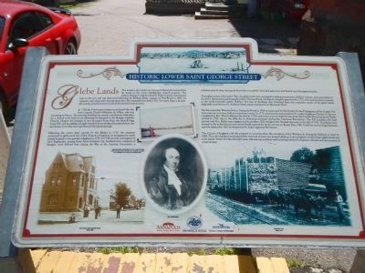
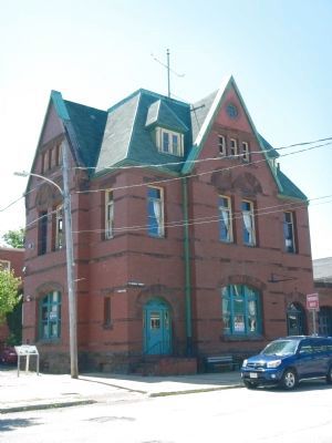
Captions: (top) Watercolour of Annapolis Royal (detail) painted by Capt. J. Hamilton, 1753.; (left to right) Post office and customs house, circa 1900.; Annapolis Royal waterfront with St. Luke’s Church under construction. Painted by Lt. Richard Williams, 1778.; Rev. Jacob Bailey; Shunting Yard, circa 1910.
In 1704 the French government purchased this site from Captain Claude-Sébastien de Villieu, who was returning to France. The existing dwelling was used as a presbytery, with plans for a church to be built on an adjoining lot donated to the Roman Catholic Church. Despite the promise of one thousand livres from the French king, Louis XIV, and an additional eight hundred livres pledged by parishioners, the new house of worship never got beyond the planning stage.
Following the town’s final capture by the British in 1710, the property continued as glebe land, but of the Church of England, an arrangement made formal by grant to the garrison chaplain in 1732. In 1748, several contingents of New Englanders, among them John Gorham’s one hundred-man company of Rangers, were billeted her during the War of the Austrian Succession, a turbulent period when Annapolis Royal was successfully defended against several French and Aboriginal attacks.
Throughout most of the mid-1700s, the glebe lands were occupied by military pensioners, soldiers’ widows, and newcomers to the town. Rents were paid annually to Rev. Thomas Wood, the deputy chaplain appointed in 1752, who had decided to remain in the newly-founded capital, Halifax. The line of dwelling that stretched from the northeast corner diagonally southwest to St. Anthony Street became known as ‘Pensioner(s)’ Row.’
The Reverend Mr. Wood moved to Annapolis Royal in 1764 as missionary for the Society for the Propagation of the Gospel. For some time services were held in a merchant’s store. In 1775 construction was started on St. Luke’s Anglican Church. It was not completed in Rev. Wood’s lifetime (he died in 1778) and in fact was not ready for use when the Loyalists Reverend Jacob Bailey arrived in 1782, due to the difficulty in obtaining materials during the American Revolution. The 500 Loyalists who had arrived with Rev. Bailey were augmented by another 2500 refugees who flooded the town in the fall of 1783. Hundreds were housed in the unfinished church which finally opened for divine service on Easter Day, 1784. It did not survive for long however, and was replaced in 1821 by the present St. Luke’s opposite Fort Anne.
The Church of England sold this property to accommodate the extension of the Windsor
& Annapolis Railway to town in 1869. That development necessitated the removal of some two dozen buildings to the periphery of the former glebe lands and to St. James’ Street. For the next fifty years, this site was a railway yard stocking lumber for shipment abroad, and the location of at train station.
Erected by Annapolis Heritage Society, Annapolis Royal National Historic District & Province of Nova Scotia.
Topics. This historical marker is listed in these topic lists: Churches & Religion • Railroads & Streetcars • War, French and Indian. A significant historical year for this entry is 1690.
Location. 44° 44.724′ N, 65° 31.136′ W. Marker is in Annapolis Royal, Nova Scotia, in Annapolis County. Marker is on St. George Street close to Church Street, on the right when traveling north. Touch for map. Marker is at or near this postal address: 208 St George Street, Annapolis Royal NS B0S, Canada. Touch for directions.
Other nearby markers. At least 8 other markers are within walking distance of this marker. Wharf & Waterfront (within shouting distance of this marker); Sinclair Inn (about 90 meters away, measured in a direct line); Major Erasmus James Philipps (about 90 meters away); Sir William Fenwick Williams (about 150 meters away); Sir William Robert Wolseley Winniett. (about 150 meters away); Rose Fortune (about 210 meters away); Annapolis Royal Historic District (about 240 meters away); Masonic Stone of 1606 (approx. 0.3 kilometers away). Touch for a list and map of all markers in Annapolis Royal.
More about this marker. The marker is next to the old Post Office.
Credits. This page was last revised on June 16, 2016. It was originally submitted on November 8, 2014, by Barry Swackhamer of Brentwood, California. This page has been viewed 561 times since then and 13 times this year. Photos: 1, 2. submitted on November 8, 2014, by Barry Swackhamer of Brentwood, California. • Andrew Ruppenstein was the editor who published this page.
