Bridgeport in Morrill County, Nebraska — The American Midwest (Upper Plains)
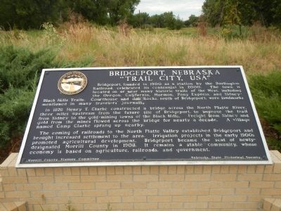
Bridgeport, Nebraska
“Trail City, USA”
In 1876 Henry T. Clarke constructed a bridge across the North Platte River three miles upstream from the future site of Bridgeport, to improve the trail from Sidney to the gold-mining town s of the Black Hills. Freight from Sidney and gold from the mines flowed across the bridge for nearly a decade. A village named Camp Clarke sprang up nearby.
The coming of railroads to the North Platte Valley established Bridgeport and brought increased settlement to the area. Irrigation projects in the early 1900s prompted agricultural development. Bridgeport became the seat of newly designated Morrill County in 1908. It remains a stable community, whose economy is based on agriculture, railroads and government.
Erected by Morrill County Visitors Committee & Nebraska State Historical Society. (Marker Number 418.)
Topics and series. This historical marker is listed in these topic lists: Bridges & Viaducts • Roads & Vehicles • Settlements & Settlers. In addition, it is included in the Nebraska State Historical Society series list. A significant historical year for this entry is 1900.
Location. 41° 40.41′ N, 103° 5.942′ W. Marker is in Bridgeport, Nebraska, in Morrill County. Marker is on Main Street (Route 26/385) near 4th Street, on the right when traveling south. Touch for map. Marker is at or near this postal address: 49 Main Street, Bridgeport NE 69336, United States of America. Touch for directions.
Other nearby markers. At least 8 other markers are within 5 miles of this marker, measured as the crow flies. Mormon Pioneer Camp (approx. half a mile away); Dedicated to the Early Pioneers (approx. 0.7 miles away); Oregon Trail (approx. 1.3 miles away); Guiding Landmarks (approx. 2.2 miles away); Dedicated to the Unknown Soldier (approx. 2.4 miles away); a different marker also named Oregon Trail (approx. 2˝ miles away); Camp Clarke Bridge and Sidney-Black Hills Trail (approx. 3.6 miles away); Courthouse and Jail Rocks (approx. 5 miles away). Touch for a list and map of all markers in Bridgeport.
Additional keywords. Sidney-Black Hills Trail
Credits. This page was last revised on June 16, 2016. It was originally submitted on December 5, 2014, by Barry Swackhamer of Brentwood, California. This page has been viewed 715 times since then and 46 times this year. Photos: 1, 2. submitted on December 5, 2014, by Barry Swackhamer of Brentwood, California. • Bill Pfingsten was the editor who published this page.

