Marriottsville in Carroll County, Maryland — The American Northeast (Mid-Atlantic)
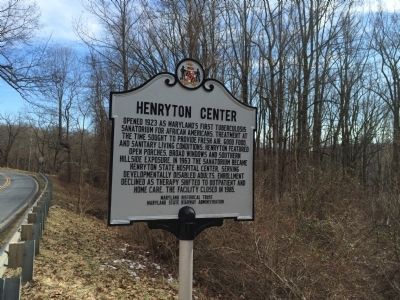
Henryton Center
Erected by Maryland Historical Trust, Maryland State Highway Administration.
Topics and series. This historical marker is listed in these topic lists: African Americans • Charity & Public Work • Science & Medicine. In addition, it is included in the Maryland Historical Trust series list. A significant historical year for this entry is 1923.
Location. Marker has been reported missing. It was located near 39° 21.356′ N, 76° 54.821′ W. Marker was in Marriottsville, Maryland, in Carroll County. Marker was on Henryton Road, one mile west of Heneryton Hospital Road, on the right when traveling east. Touch for map. Marker was in this post office area: Marriottsville MD 21104, United States of America. Touch for directions.
Other nearby markers. At least 8 other markers are within 3 miles of this location, measured as the crow flies. Henryton School of Practical Nursing (a few steps from this marker); In Memory of All American Veterans (approx. 1.9 miles away); Veterans Memorial (approx. 1.9 miles away); History of the Freedom Community (approx. 2.4 miles away); The Sykesville Bypass Bridge (approx. 2.9 miles away); Sykesville (approx. 3 miles away); Baldwin's Station (approx. 3 miles away); Baltimore & Ohio Railroad Station (approx. 3 miles away).
More about this marker. Marker was photographed in 2015 at 39° 21.362′ N, 76° 54.807′ W. In August 2019 Google Maps Street View showed it across the road at the intersection, where we have it located now.
Credits. This page was last revised on May 28, 2022. It was originally submitted on February 4, 2015, by Pete Skillman of Townsend, Delaware. This page has been viewed 689 times since then and 41 times this year. Photo 1. submitted on February 4, 2015, by Pete Skillman of Townsend, Delaware. • Bill Pfingsten was the editor who published this page.
