Lometa in Lampasas County, Texas — The American South (West South Central)
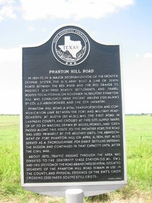
Phantom Hill Road
The Phantom Hill Road, the vital transportation and communication link between the fort and military headquarters at Austin (80 mi. SE), was the first road in Lampasas County, and crossed at this site. Supply trains of up to 24 wagons drawn by mules, horses, and oxen passed along this route to the frontier fort. The road was used primarily by the military until the abandonment of Fort Phantom Hill on April 6, 1854, but also served as a thoroughfare for early settlers entering the region and continued in that capacity until after the Civil War.
About 1870, traffic passing through the area was diverted to the Senterfitt Stage Station (1.5 mi. SW), and this section of the road abandoned. Several isolated segments of the Phantom Hill Road remain in use in the county, and physical evidence of the Emy's Creek Crossing (200 yards south) still exists.
Erected 1974 by Texas Historical Commission. (Marker Number 4004.)
Topics. This historical marker is listed in these topic lists: Forts and Castles • Roads & Vehicles • Settlements & Settlers • Wars, US Indian. A significant historical month for this entry is April 1964.
Location. 31° 13.171′ N, 98° 25.781′ W. Marker is in Lometa, Texas, in Lampasas County. Marker is on U.S. 190, 1˝ miles west of Main Street (County Route 581), on the right when traveling west. Touch for map. Marker is in this post office area: Lometa TX 76853, United States of America. Touch for directions.
Other nearby markers. At least 8 other markers are within 3 miles of this marker, measured as the crow flies. Site of Lometa Reservoir (approx. 1.4 miles away); Senterfitt Cemetery (approx. 1.4 miles away); Site of the Town of Senterfitt (approx. 1.6 miles away); C.S.A. Salts Works (approx. 1.9 miles away); Lometa (approx. 2.1 miles away); Scholten Railroad (approx. 2.4 miles away); Veterans of Lampasas County (approx. 2.7 miles away); Operation Long Horn (approx. 2.7 miles away). Touch for a list and map of all markers in Lometa.
Credits. This page was last revised on June 16, 2016. It was originally submitted on March 24, 2015, by Richard Denney of Austin, Texas. This page has been viewed 771 times since then and 43 times this year. Photos: 1, 2. submitted on March 24, 2015, by Richard Denney of Austin, Texas. • Bernard Fisher was the editor who published this page.

