Near Truckee in Nevada County, California — The American West (Pacific Coastal)
Donner Summit Canyon History
Photographed By Barry Swackhamer, August 30, 2014
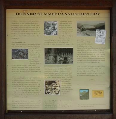
1. Donner Summit Canyon History Marker
Captions: (left column) Petroglyphs located near Donner Pass; (center column) Crossing the pass by wagon was a challenging endeavor in any weather conditions., Cutting edge transportation infrastructure in the early 20th century, Newly developed automobile underpasses offered a much safer way to cross the railroad tracks, particularly in areas with snow sheds, tunnels, and short lines of sight., Chinese workers on Donner Summit.; (right column, no captions).
Native Americans
Native Americans seasonally crossed the Sierra over what we today refer to as Donner Pass. Petroglyphs from the Martis people, estimated to be up to 2,500 years old, can be viewed on the slabs just west of the Donner Summit (Rainbow) Bridge on Old U.S. 40. The Northern Paiute, Western Shoshoni, and Washoe people of the Great Basin, as well as the Maidu of the western foothills of the Sierra, are believed to have traversed this pass as a trade route.
Euro-American Westward Expansion
In 1844, the Stephens-Townsend-Murphy Party was the first group of Euro-American emigrants to successfully cross the summit into California. Due to early snowfall, they left their wagons at the east end of “Truckee Lake” under the watchful eye of young Moses Schallenberger, who wintered in a hastily-constructed cabin. The high ridge rising from the south shore of today’s Donner Lake, is named Schallenberger Ridge.
The tragedy of the Donner Party is well-known. The party was late moving into the Sierra in October of 1846. They became trapped in early, heavy snows both at the Donner’s camp six miles northeast of “Truckee Lake” in Alder Creek Valley, and on the lake’s east shore. The party quickly exhausted their food supply, hunting was challenging, and their oxen were lost to snowdrifts. A small group did make it over the summit, bringing back supplies and assisting in rescuing the survivors the following spring.
In 1862, the federal government, fully engaged in the Civil War, did not have the ability to finance the transcontinental railroad it dearly wanted, and instead supported it with U.S. Government bonds and land grants to Central Pacific Railroad. Above the property you can view the famous China Wall, a dry-laid rock wall constructed by Chinese laborers, hand-cut train tunnels, and snowsheds to protect the trains from avalanches.
As the Central Pacific built the railroad across the Sierra, they needed a way to move construction materials and laborers to the summit. Thus, they built the Dutch Flat-Donner Lake Wagon Road and operated it as a toll road from 1864 to 1867. Upon completion of the railroad, the old wagon road fell into disrepair. After the turn of the century, the old road was modified for
Photographed By Barry Swackhamer, August 30, 2014
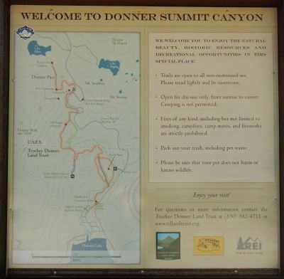
2. Welcome to Donner Summit Canyon
We welcome you to enjoy the natural beauty, historic resources and recreational opportunities in this special place.
• Trails are open to all non-motorized use. Please tread lightly and be courteous.
• Open for day-use only, from sunrise to sunset. Camping is not permitted.
• Fires of any kind, including but not limited to smoking, campfires, camp stoves, and fireworks are strictly prohibited.
• Pack out you trash, including pet waste.
• Please be sure that you pet does not harm or harass wildlife.
For questions or more information contact the Truckee Donner Land Trust at (530) 582-4711 or www. tdlandtrust.org.
Lands surrounding Donner Lake including Donner Summit Canyon, Schallenberger Ridge, and Lakeview, Cold Stream, and Emigrant Canyons, are now permanently protected and open to the public as additions to Donner Memorial State Park.
Erected by Truckee Donner Land Trust & Donner Summit Historical Society.
Topics and series. This historical marker is listed in these topic lists: Native Americans • Railroads & Streetcars • Roads & Vehicles • Settlements & Settlers. In addition, it is included in the Donner Summit Historical Society, and the Lincoln Highway series lists. A significant historical month for this entry is October 1846.
Location. 39° 19.356′ N, 120° 17.857′ W. Marker is near Truckee, California, in Nevada County. Marker is on Donner Pass Road near Edie Court, on the right when traveling east. Touch for map. Marker is at or near this postal address: 16395 Donner Pass Road, Truckee CA 96161, United States of America. Touch for directions.
Other nearby markers. At least 8 other markers are within 2 miles of this marker, measured as
Photographed By Barry Swackhamer, August 30, 2014
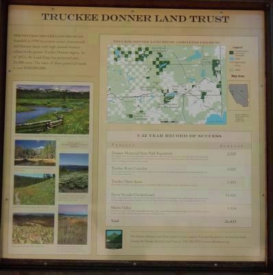
3. Truckee Donner Land Trust
The Truckee Donner Land Trust was founded in 1990 to protect scenic, recreational and historical lands with high natural resource values in the greater Truckee Donner region. As of 2012, the Land Trust has protected over 26,000 acres. The value of these protected lands is over $100,000,000.
A 22 Year Record of Success
Projects
Donner Memorial State Park Expansion: Donner Lake has inspired generations of travelers through the Sierra and visitors to Truckee. The Land Trust has focused on protecting the tributaries that provide Donner Lake with clean, clear water and ensuring that the scenic viewshed remains intact and beautiful. Due to Land Trust acquisitions, Donner Memorial State Park has nearly tripled in size, making it one of California’s largest parks. — Acreage 2,520
Truckee River Corridor: The scenic, rugged canyon between Truckee and Verdi, Nevada includes 100 acres of Truckee River frontage providing improved access to recreational opportunities and protecting important wildlife habitat. — Acreage 5,025
Truckee Open Space: The conservation of the greater Truckee region’s open space ensures greenbelts, wildlife corridors, splendid views and a variety of options for recreation. — Acreage 1,453
Sierra Nevada Checkerboard: The Sierra Nevada Checkerboard is a mosaic of private and public land parcels dating back to the 19th Century Land Grants. Land Trust projects in this area have protected Cold Stream Meadow, Carpenters Ridge, Independence Lake basin, Pierce Meadow, Paradise Valley, Penaesu Meadows and the Historic Henness Pass Road Corridor. — Acreage 15,521
Martis Valley: These properties off SR 267 near Truckee, including Waddle Ranch Preserve, offer a network of hiking and biking trails for exploring historic Native American and pioneer grounds, viewing wildlife at Lake Ella, and enjoying creeks, meadows and High Sierra vistas. Acreage— 1,914
Total Acreage — 26,433
Showcase of Truckee Donner Land Trust Projects: (top to bottom) The Little Truckee River flows through Penaesu Meadow.; Donner Summit Canyon beaver pond.; The Land Trust has worked to protect all of the major tributaries to Donner Lake including Gregory Creek in Negro Canyon.; Webber Lake and Lacey Valley.; The Land Trust has preserved nearly 2,500 acres in the Martis Valley.
Credits. This page was last revised on June 16, 2016. It was originally submitted on March 26, 2015, by Barry Swackhamer of Brentwood, California. This page has been viewed 540 times since then and 30 times this year. Photos: 1, 2, 3, 4, 5. submitted on March 26, 2015, by Barry Swackhamer of Brentwood, California. • Syd Whittle was the editor who published this page.
Editor’s want-list for this marker. Wide area view of the panels as they appear. • Can you help?
