Howick in Le Haut-Saint-Laurent, Québec — Central Canada (French-Canadian)
The Battle of the Châteauguay
Bataille de la Châteauguay
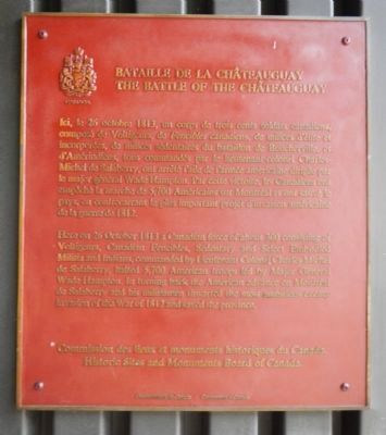
Here, on 26 October 1813, a Canadian force of about 300 consisting of Voltigeurs, Canadian Fencibles, Sedentary and Select Embodied Militia and Indians, commanded by Lieutenant Colonel Charles Michel de Salaberry, halted 5,700 American troops led by Major General Wade Hampton. In turning back the American advance on Montréal de Salaberry and his militiamen thwarted the most ambitious enemy invasion of the War of 1812 and saved the province.
French:
Ici, le 26 octobre 1813, un corps de trois cents soldats canadiens composé de Voltigeurs, de Fencibles canadiens, de milices d'élite et incorporées, de milices sédentaires du bataillon de Boucherville et d'Amérindiens, tous commandés par le lieutenant-colonel Charles-Michel de Salaberry, ont arrêté l'aile de l'armée américaine dirigée par le major général Wade Hampton. Par cette victoire, les Canadiens ont empêche la marche de 5,700 Américains sur Montréal et ont sauvé le pays, en contrecarrant le plus important projet d'invasion américaine de la guerre de 1812.
Erected by Historic Sites and Monument Board of Canada/Commission de lieux et monuments historique du Canada.
Topics and series. This historical marker is listed in this topic list: War of 1812. In addition, it is included in the Canada, Historic Sites and Monuments Board series list. A significant historical date for this entry is October 26, 1813.
Location. 45° 9.52′ N, 73° 55.728′ W. Marker is in Howick, Québec, in Le Haut-Saint-Laurent. Marker is on Chemin de la Rivière-Châteauguay-nord, 0.2 kilometers west of Rang du 40, on the left when traveling west. Touch for map. Marker is at or near this postal address: 2371 Chemin de la Rivière-Châteauguay-nord, Howick QC J0S 1G0, Canada. Touch for directions.
Credits. This page was last revised on January 23, 2022. It was originally submitted on April 1, 2015, by Barry Swackhamer of Brentwood, California. This page has been viewed 558 times since then and 16 times this year. Photos: 1, 2, 3. submitted on April 1, 2015, by Barry Swackhamer of Brentwood, California. • Andrew Ruppenstein was the editor who published this page.


