Knoxville in Knox County, Tennessee — The American South (East South Central)
Fort Sanders
Decisive Battle for Knoxville
— Knoxville Campaign —
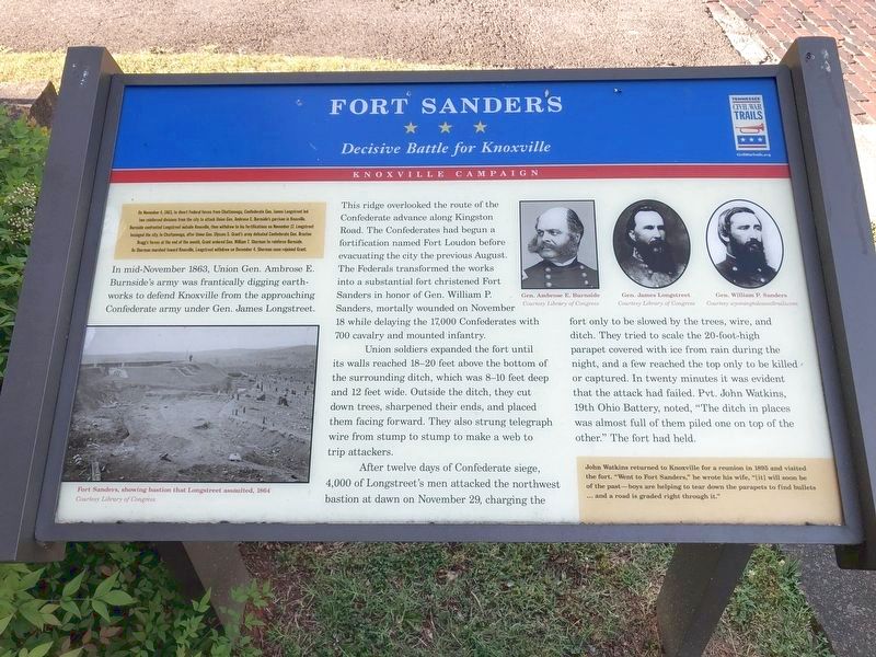
On November 4, 1863, to divert Federal forces from Chattanooga, Confederate Gen. James Longstreet led two reinforced divisions from the city to attack Union Gen. Ambrose E. Burnside’s garrison in Knoxville. Burnside confronted Longstreet outside Knoxville, then withdrew to his fortification on November 17, and Longstreet besieged the city. In Chattanooga, after Union Gen. Ulysses S. Grant’s army defeated Confederate Gen. Braxton Bragg’s forces at the end of the month, Grant ordered Gen. William T. Sherman to reinforce Burnside. As Sherman marched toward Knoxville, Longstreet withdrew on December 4. Sherman soon rejoined Grant.
(main text)
In mid-November 1863, Union Gen. Ambrose E. Burnside’s army was frantically digging earthworks to defend Knoxville from the approaching Confederate army under Gen. James Longstreet. This ridge overlooked the route of the Confederate advance along Kingston Road. The Confederates had begun a fortification named Fort Loudon before evacuating the city the previous August. The Federals transformed the works into a substantial fort christened Fort Sanders in honor of Gen. William P. Sanders, mortally wounded on November 18, while delaying the 17,000 Confederates with 700 cavalry and mounted infantry.
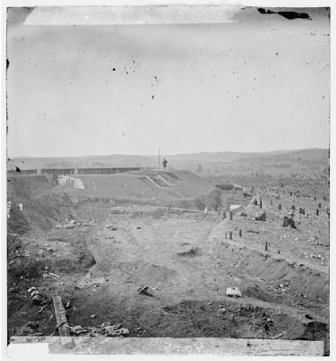
Union soldiers expanded the fort until its wall reached 18-20 feet above the bottom of the surrounding ditch, which was 8-10 feet deep and 12 feet wide. Outside the ditch, they cut down trees, sharpened their ends, and placed them facing forward. They also strung telegraph wire from stump to stump to make a web to trip attackers.
After twelve days of Confederate siege, 4,000 of Longstreet’s men attacked the northwest bastion at dawn on November 29, charging the fort only to be slowed by the trees, wire and ditch. They tried to scale the 20-foot-high parapet covered with ice from rain during the night, and a few reached the top only to be killed or captured. In twenty minutes it was evident that the attack had failed. Pvt. John Watkins, 19th Ohio Battery, noted, “The ditch in places was almost full of them piled one on top of the other.” The fort had held.
(sidebar)
John Watkins returned to Knoxville for a reunion in 1895 and visited the fort. “Went to Fort Sanders,” he wrote his wife, “(it) will soon be of the past—boys are helping to tear down the parapets to find bullets… and a road is graded right through it."
(captions)
Photo showing bastion that Longstreet assaulted, 1864 Courtesy Library of Congress
Gen. Ambrose E. Burnside Courtesy Library of Congress
Gen. James Longstreet Courtesy Library of Congress
Gen. William P. Sanders Courtesy wyomingtalesandtrails.com
Erected by Tennessee Civil War Trails.
Topics and series. This historical marker is listed in these topic lists: Forts and Castles • War, US Civil. In addition, it is included in the Tennessee Civil War Trails series list. A significant historical month for this entry is November 1780.
Location. 35° 57.58′ N, 83° 56.042′ W. Marker is in Knoxville, Tennessee, in Knox County. Marker is at the intersection of South 17th Street and Highland Avenue, on the left when traveling south on South 17th Street. The marker is located on the grounds of the Redeemer Church of Knoxville. Touch for map. Marker is at or near this postal address: 1642 Highland Ave, Knoxville TN 37916, United States of America. Touch for directions.
Other nearby markers. At least 8 other markers are within walking distance of this marker. The Assault Upon Fort Sanders (about 300 feet away, measured in a direct line); Fort Sanders U.D.C. Monument (about 400 feet away); 79th New York Infantry (Highlanders) Monument (approx. 0.2 miles away); a different marker also named Fort Sanders (approx. ¼ mile away); General Clifton Bledsoe Cates (approx. 0.3 miles away); James Rufus Agee (approx. 0.3 miles away); Fort Byington (approx. 0.3 miles away); Wait Field (approx. 0.4 miles away). Touch for a list and map of all markers in Knoxville.
Credits. This page was last revised on March 16, 2022. It was originally submitted on October 19, 2013, by Don Morfe of Baltimore, Maryland. This page has been viewed 1,294 times since then and 41 times this year. Last updated on April 7, 2015, by J. Makali Bruton of Accra, Ghana. Photos: 1. submitted on March 16, 2022, by Pete Skillman of Townsend, Delaware. 2. submitted on October 19, 2013, by Don Morfe of Baltimore, Maryland. 3. submitted on October 21, 2013. • Bill Pfingsten was the editor who published this page.


