Ramona in San Diego County, California — The American West (Pacific Coastal)
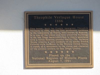
Theophile Verlaque House
1886
Placed on the National Register of Historic Places August 7, 1991
Topics. This historical marker is listed in this topic list: Settlements & Settlers. A significant historical year for this entry is 1886.
Location. 33° 2.713′ N, 116° 51.801′ W. Marker is in Ramona, California, in San Diego County. Marker is on Main Street, on the right when traveling west. Touch for map. Marker is at or near this postal address: 645 Main Street, Ramona CA 92065, United States of America. Touch for directions.
Other nearby markers. At least 8 other markers are within 12 miles of this marker, measured as the crow flies. Verlaque House (1886) (here, next to this marker); Ramona Town Hall (about 400 feet away, measured in a direct line); An Incident of the Mexican War (approx. 7.6 miles away); San Pasqual (approx. 7.9 miles away); San Pasqual Battlefield (approx. 7.9 miles away); Dearborn Memorial Park (approx. 10.6 miles away); DJ Ranch Formerly: Kent Farm (approx. 10.8 miles away); City of Poway Veterans Park (approx. 11.3 miles away). Touch for a list and map of all markers in Ramona.
Credits. This page was last revised on June 16, 2016. It was originally submitted on April 11, 2015, by Bill Kirchner of Tucson, Arizona. This page has been viewed 368 times since then and 22 times this year. Photos: 1, 2, 3. submitted on April 11, 2015, by Bill Kirchner of Tucson, Arizona. • Andrew Ruppenstein was the editor who published this page.


