Near West Side in Chicago in Cook County, Illinois — The American Midwest (Great Lakes)
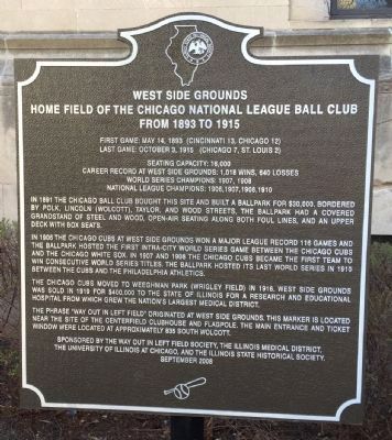
West Side Grounds
Home Field of the Chicago National League Ball Club from 1893 to 1915
Last Game: October 13, 1915 (Chicago 7, St. Louis 2)
Seating Capacity: 16,000
Career Record at West Side Grounds: 1,018 wins, 640 loses
World Series Champions: 1907, 1908
National League Champions: 1906, 1907, 1908, 1910
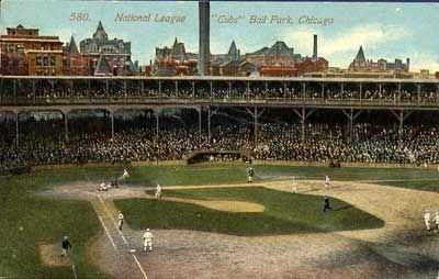
In 1891 the Chicago Ball Club bought this site and built a ball park for $30,000. Bordered by Polk, Lincoln (Wolcott), Taylor and Wood Streets, the ballpark has a covered grandstand of steel and wood, open-air seating along both foul lines, and an upper deck with box seats.
In 1906 the Chicago Cubs at West Side Grounds won a major league record 116 games and the ballpark hosted the first intra-city world series game between the Chicago Cubs and the Chicago White Sox. In 1907 and 1908 the Chicago Cubs became the first team to win consecutive World Series titles. The ballpark hosted it last World Series in 1910 between the Cubs and the Philadelphia Athletics.
The Chicago Cubs moved to Weeghman Park (Wrigley Field) in 1916. West Side Grounds was sold in 1919 for $400,000 to the state of Illinois for a research and educational hospital from which grew the nation’s largest medical district.
The phrase “Way out in left field” originated at West Side Grounds. This marker is located near the site of the centerfield clubhouse and flagpole. The main entrance and ticket window were located at approximately 835 South Wolcott.
Erected 2008 by Way Out in Left Field Society, Illinois Medical District, University of Illinois at Chicago & Illinois State Historical Society.
Topics and series. This historical marker is listed in this topic list: Sports. In addition, it is included in the Illinois State Historical Society series list. A significant historical month for this entry is May 1861.
Location. 41° 52.203′ N, 87° 40.293′ W. Marker is in Chicago, Illinois, in Cook County. It is in the Near West Side. Marker is on South Wood Street near West Taylor StreetThi when traveling south. Touch for map. Marker is at or near this postal address: 912 South Wood Street, Chicago IL 60612, United States of America. Touch for directions.
Other nearby markers. At least 8 other markers are within walking distance of this marker. Jackson Boulevard (approx. 0.6 miles away); a different marker also named Jackson Boulevard (approx. 0.6 miles away); Jackson Boulevard District (approx. 0.6 miles away); a different marker also named Jackson Boulevard (approx. 0.7 miles away); Saint Frances Xavier Cabrini (approx. ¾ mile away); Robert Marvin "Bobby" Hull (approx. 0.8 miles away); Stanislav "Stan" Mikita (approx. 0.8 miles away); Carter H. Harrison (approx. 0.9 miles away). Touch for a list and map of all markers in Chicago.
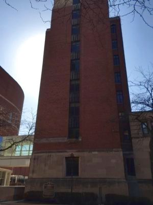
More about this marker. This marker is located near the Neuropsychiatric Institue Building on the University of Illinois at Chicago Campus.
Also see . . . West Side Grounds - Wikipedia. In May 1893, the club opened the second West Side Park a few blocks west-southwest of the first one, on a larger block bounded by Taylor, Wood, Polk and Lincoln (now Wolcott) Streets. It was located at 41°52′13″N 87°40′21″W. They split their 1893 schedule with South Side Park, then moved into the new ballpark full-time the following year. Some sources state that the club moved to this location to gain attendance from the World's Columbian Exposition, as South Side Park was within walking distance of the 35th Street station on the new South Side Rapid Transit line, which reached the exposition grounds at Jackson Park. (Submitted on April 13, 2015, by Barry Swackhamer of Brentwood, California.)
Credits. This page was last revised on January 30, 2023. It was originally submitted on April 13, 2015, by Barry Swackhamer of Brentwood, California. This page has been viewed 1,034 times since then and 151 times this year. Photos: 1, 2, 3. submitted on April 13, 2015, by Barry Swackhamer of Brentwood, California. • Andrew Ruppenstein was the editor who published this page.


