Manheim Township near Lancaster in Lancaster County, Pennsylvania — The American Northeast (Mid-Atlantic)
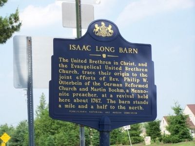
Isaac Long Barn
Erected 1960 by Pennsylvania Historical and Museum Commission.
Topics and series. This historical marker is listed in these topic lists: Churches & Religion • Colonial Era. In addition, it is included in the Pennsylvania Historical and Museum Commission series list. A significant historical year for this entry is 1767.
Location. 40° 5.449′ N, 76° 16.813′ W. Marker is near Lancaster, Pennsylvania, in Lancaster County. It is in Manheim Township. Marker is at the intersection of Kissel Hill Road and Landis Valley Road, on the right when traveling south on Kissel Hill Road. Touch for map. Marker is at or near this postal address: 2420 Kissel Hill Rd, Lancaster PA 17601, United States of America. Touch for directions.
Other nearby markers. At least 8 other markers are within 3 miles of this marker, measured as the crow flies. Henry Hess Landis Farm (approx. 0.2 miles away); Landis Graveyard (approx. 0.8 miles away); 1954 (approx. 1.6 miles away); Hunsecker Covered Bridge (approx. 1.8 miles away); Pinetown Bridge (approx. 2 miles away); Belmont Lime kiln (approx. 2.3 miles away); Belmont Quarry (approx. 2.4 miles away); Mayer Cemetery (approx. 2˝ miles away). Touch for a list and map of all markers in Lancaster.
Credits. This page was last revised on February 7, 2023. It was originally submitted on June 9, 2008, by Bill Pfingsten of Bel Air, Maryland. This page has been viewed 1,969 times since then and 54 times this year. Photos: 1, 2. submitted on June 9, 2008, by Bill Pfingsten of Bel Air, Maryland.

