Santa Tecla, La Libertad, El Salvador — Central America (West Coast)
El Cafetalón
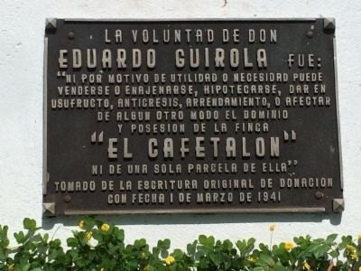
La voluntad de Don Eduardo Guirola fue:
“Ni por motivo de utilidad o necesidad puede venderse o enajenarse, hipotecarse, dar en usufructo, anticresis, arrendamiento, o afectar de algun otro modo el dominio y posesion de la finca
“El Cafetalon”
Ni de una sola parcela de ella.”
Tomado de la escriture original de donacion con fecha 1 de marzo de 1941
It was the desire of Eduardo Guirola that: “For no reason of utility or need can the property be sold, given away, mortgaged, loaned, rented or in any other way managed in which the possession of the farm or any parcel of it be affected.”
“El Cafetalon”
Words taken from the original deed donating the property on March 1, 1941
Topics. This historical marker is listed in this topic list: Parks & Recreational Areas. A significant historical month for this entry is March 2004.
Location. 13° 40.505′ N, 89° 16.957′ W. Marker is in Santa Tecla, La Libertad. Marker can be reached from 7 Avenida Norte just east of 7a Avenida Norte, on the left when traveling east. Touch for map. Marker is in this post office area: Santa Tecla, La Libertad 01501, El Salvador. Touch for directions.
Other nearby markers. At least 8 other markers are within walking distance of this marker. Adalberto Guirola Children’s Home (about 120 meters away, measured in a direct line); One Hundred Years Since the Founding of Santa Tecla (approx. 0.3 kilometers away); Dr. Manuel Gallardo (approx. 0.6 kilometers away); Kiosk of Daniel Hernández Plaza (approx. 0.7 kilometers away); Tribute to Santa Tecla (approx. 0.7 kilometers away); Santa Tecla Culture and Arts Center (approx. 0.7 kilometers away); Madre Clara Maria de Jesus Quiros (approx. 0.7 kilometers away); Monument to the Victims of Las Colinas Landslide (approx. 1.2 kilometers away). Touch for a list and map of all markers in Santa Tecla.

Photographed By J. Makali Bruton, May 17, 2015
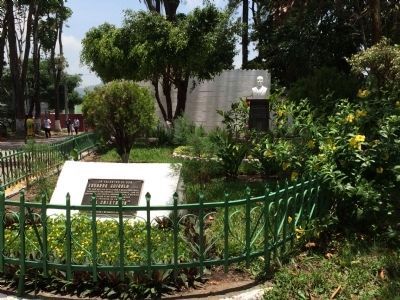
2. Wide view of El Cafetalón Marker
The bust of the donor of this former coffee plantation, Eduardo Guirola is seen in the background. It includes a small marker noting that a foundation was created to manage the property as a park on January 11, 1979. The park has soccer fields, bicycle paths and a public swimming pool.
Credits. This page was last revised on April 2, 2023. It was originally submitted on May 22, 2015, by J. Makali Bruton of Accra, Ghana. This page has been viewed 418 times since then and 16 times this year. Photos: 1, 2. submitted on May 22, 2015, by J. Makali Bruton of Accra, Ghana. • Andrew Ruppenstein was the editor who published this page.
