Olympic National Forest in Clallam County, Washington — The American West (Northwest)
Rain Forest Monarch
Inscription.
The temperate rain forest is dominated by Sitka spruce. Except where it penetrates valley such as the Hoh, the Sitka spruce grows along a narrow coastal strip from northern California to Alaska.
High rainfall, fog, and ocean-moderated temperatures create optimum growing conditions for these monarchs. This is one of the largest Sitka spruce trees in the United States.
Height ... over 270 feet • Diameter at breast height ... over 12½ feet • Age ... 500 to 550 years.
At dawn and dusk be alert for elk crossing road.
Erected by National Park Service.
Topics. This historical marker is listed in these topic lists: Horticulture & Forestry • Natural Features.
Location. 47° 50.208′ N, 123° 58.452′ W. Marker is in Olympic National Forest, Washington, in Clallam County. Marker is on Upper Hoh Road, 15˝ miles east of U.S. 101, on the right when traveling east. It is at a small parking lot between the entrance-fee booth and the visitor’s center. Touch for map. Marker is in this post office area: Forks WA 98331, United States of America. Touch for directions.
Other nearby markers. At least 7 other markers are within 9 miles of this marker, measured as the crow flies. Fort Ross, California - Sitka Castle, Alaska - Fort Elisabeth, Kaua’i, Hawai’i (approx. 8.4 miles away); Anna Petrovna - Timothei Tarakanov (approx. 8.4 miles away); Makah Indian Tribe (approx. 8.4 miles away); Hoh Indian Tribe (approx. 8.4 miles away); Escape to the Hoh River Leads to Captivity (approx. 8.4 miles away); Quileute Indian Tribe (approx. 8.4 miles away); Sv. Nikolai Mission (approx. 8.4 miles away).
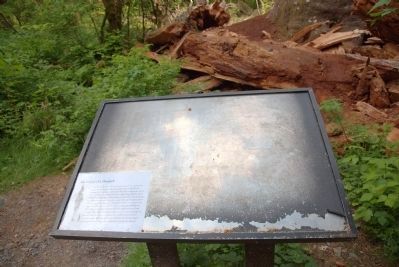
More about this marker. Interpretive panel was removed after the tree fell in 2014 and replaced with a temporary laminated placard.
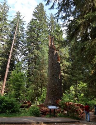
Regarding Rain Forest Monarch. Winds associated with a storm on December 9th, 2014, snapped the tree in two, resulting in a standing dead tree, or snag, and a nurse log lying on the forest floor.
Also see . . . Visiting the Hoh Rain Forest. National Park Service page. (Submitted on May 24, 2015.)
Additional commentary.
1. Temporary Laminated Placard “The Legacy of a Monarch”
This imposing monolith is an impressive reminder of what was once one of the largest Sitka spruce trees in the world. Winds associated with a storm on December 9th, 2014, snapped the tree in two, resulting in a standing dead tree, or snag. Snags add diversity to the forest’s structure by providing places for animals to perch and get a good view of the forest floor from above. They also are great places to carve out cavities to nest in. A few years from now you may come back to this place and spot the head of a woodpecker peeking out from a hole, waiting for its mother to return with some tasty food.
Lying on the forst floor a short distance away is the remainder of the tree. New trees will soon sprout from seeds that have landed along its length. Seedlings will begin their lives on this nurse log by deriving nutrients that are slowly released as the log decomposes.
— Submitted May 24, 2015, by J. J. Prats of Powell, Ohio.
Credits. This page was last revised on June 16, 2016. It was originally submitted on May 24, 2015, by J. J. Prats of Powell, Ohio. This page has been viewed 576 times since then and 48 times this year. Photos: 1, 2. submitted on May 24, 2015, by J. J. Prats of Powell, Ohio.
Editor’s want-list for this marker. Photo of the original interpretative panel before it was removed • Photo of the tree, before it fell • Can you help?

