Maysville in Mason County, Kentucky — The American South (East South Central)
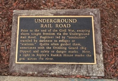
Underground Rail Road
— Circa 1840 —
Prior to the end of the Civil War, escaping slaves sought freedom via the Underground Rail Road. Fugitives led by "conductors" traveled by darkness to refuges or "stations." Quilts often guided them, sometimes with the Drinking Gourd (Big Dipper) and safety or danger marks. Here, a light in Ripley's Rankin House marks the goal across the river.
Erected 1998 by Maysville-Mason County Area Chamber of Commerce, Limestone Economic Development, Inc.
Topics. This historical marker is listed in these topic lists: Abolition & Underground RR • African Americans • War, US Civil.
Location. 38° 38.879′ N, 83° 45.751′ W. Marker is in Maysville, Kentucky, in Mason County. Marker can be reached from East McDonald Parkway, 0.1 miles Limestone Street. Touch for map. Marker is at or near this postal address: 25 East McDonald Parkway, Maysville KY 41056, United States of America. Touch for directions.
Other nearby markers. At least 8 other markers are within walking distance of this marker. Front Street Maysville, 1850 (a few steps from this marker); Maysville River Front 1900 (a few steps from this marker); La Fayette's Visit to Maysville (a few steps from this marker); Limestone Landing (within shouting distance of this marker); Buffalo Trace (within shouting distance of this marker); Lewis and Clark in Kentucky / John Colter (ca. 1775-1813) (within shouting distance of this marker); Maysville Shipbuilding / "Maysville's" Voyaging (within shouting distance of this marker); Mason County Spy Company (within shouting distance of this marker). Touch for a list and map of all markers in Maysville.
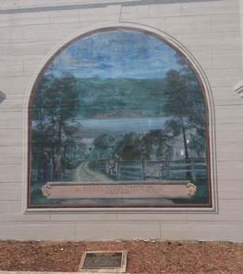
Regarding Underground Rail Road. This mural symbolizes the plight of escaping slaves using the Underground Railroad. The artist shows hidden messages, that according to oral history, communicated to the slaves the route and timing for passage to freedom.
For example the quilts hanging on the split rail fence carried encoded messages as well as the Big Dipper constellation showed the fleeing slaves which direction was north.
Across the river and high on the bluff is the small house belonging to the Reverend John Rankin, a noted abolitionist and stationmaster conductor of the Underground Railroad. A light in the window indicated the timing was safe for passage to the house.
The escaping slaves freedom was still in jeopardy until they reached Canada.
Also see . . . Welcome to the National Underground Railroad Museum. Website homepage (Submitted on January 3, 2023, by Larry Gertner of New York, New York.)
Credits. This page was last revised on January 3, 2023. It was originally submitted on June 1, 2015, by Mark Hilton of Montgomery, Alabama. This page has been viewed 547 times since then and 18 times this year. Photos: 1, 2, 3. submitted on June 1, 2015, by Mark Hilton of Montgomery, Alabama.


