Maysville in Mason County, Kentucky — The American South (East South Central)
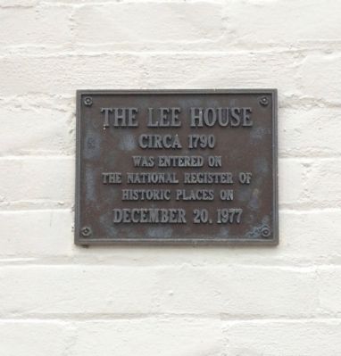
The Lee House
Circa 1790
Circa 1790
was entered on
the National Register of
Historic Places on
December 20, 1977
Erected by the Department of the Interior.
Topics. This historical marker is listed in these topic lists: Landmarks • Notable Buildings. A significant historical date for this entry is December 20, 1977.
Location. 38° 38.954′ N, 83° 45.958′ W. Marker is in Maysville, Kentucky, in Mason County. Marker is at the intersection of West Front Street and Sutton Street on West Front Street. Touch for map. Marker is at or near this postal address: West Front Street, Maysville KY 41056, United States of America. Touch for directions.
Other nearby markers. At least 8 other markers are within walking distance of this marker. Noted Historian (within shouting distance of this marker); Lafayette's Tour (about 400 feet away, measured in a direct line); Kentucky Historian (about 500 feet away); Phillips' Folly (about 600 feet away); Limestone (about 600 feet away); Stanley Forman Reed (about 700 feet away); Shackleford Residence (approx. 0.2 miles away); Rosemary Clooney (approx. 0.2 miles away). Touch for a list and map of all markers in Maysville.
Also see . . . Lee House Inn website. (Submitted on June 1, 2015, by Mark Hilton of Montgomery, Alabama.)
Credits. This page was last revised on November 4, 2020. It was originally submitted on June 1, 2015, by Mark Hilton of Montgomery, Alabama. This page has been viewed 370 times since then and 22 times this year. Photos: 1, 2, 3. submitted on June 1, 2015, by Mark Hilton of Montgomery, Alabama.


