Narrows in Giles County, Virginia — The American South (Mid-Atlantic)
Narrows
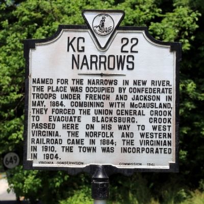
Named for the narrows in New River. The place was occupied by Confederate troops under French and Jackson in May, 1864. Combining with McCausland, they forced the Union General Crook to evacuate Blacksburg. Crook passed here on his way to West Virginia. The Norfolk and Western Railroad came in 1884; The Virginian in 1910. The town was incorporated in 1904.
Erected 1941 by Virginia Conservation Commission. (Marker Number KG-22.)
Topics and series. This historical marker is listed in these topic lists: Political Subdivisions • Railroads & Streetcars • War, US Civil. In addition, it is included in the Virginia Department of Historic Resources (DHR) series list. A significant historical month for this entry is May 1864.
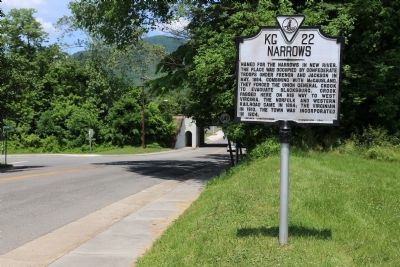
Location. 37° 19.943′ N, 80° 48.648′ W. Marker is in Narrows, Virginia, in Giles County. Marker is on MacArthur Lane (Virginia Route 61) just south of Princeton Lane (Lurich Road) (County Route 649), on the left when traveling south. From US 360, take the Route 61 exit into Narrows. The marker is just beyond the N&W overpass, on the left. Touch for map. Marker is in this post office area: Narrows VA 24124, United States of America. Touch for directions.
Other nearby markers. At least 8 other markers are within 5 miles of this marker, measured as the crow flies. New River (approx. 2.6 miles away); First Court of Giles County (approx. 3.1 miles away); West Virginia / Giles County Virginia (approx. 4 miles away); McClaugherty Mill Stone (approx. 4.2 miles away); Pearisburg (approx. 4.2 miles away); Giles County Confederate Monument (approx. 4.2 miles away); Giles County War Memorial (approx. 4.2 miles away); Revolutionary War Soldiers of Giles County (approx. 4.2 miles away).
Also see . . .
1. Historical Summary. Town of Narrrows website entry (Submitted on February 26, 2022, by Larry Gertner of New York, New York.)
2. Norfolk & Western Railway. Wikipedia entry:
“The Norfolk and Western Railway (reporting mark NW), was a US class I railroad, formed by more than 200 railroad mergers between 1838 and 1982. It was headquartered in Roanoke, Virginia, for most of its 150-year existence. Its motto was ‘Precision Transportation;’ it had a variety of nicknames, including ‘King Coal’ and ‘British Railway of America’ even though the N&W had mostly articulated steam on its roster. During the Civil War, the N&W was the biggest railroad in the south and moved most of the products with their steam locomotives to help the South the best way they could.
“NW was famous for manufacturing its own steam locomotives, which were produced at the Roanoke Shops, as well as its own hopper cars. Around 1960, NW became the last major American railroad to convert from steam to diesel motive power. In December 1959, NW merged with the Virginian Railway (reporting mark VGN), a longtime rival in the Pocahontas coal region.” (Submitted on June 5, 2015.)
3. Virginian Railway. Wikipedia entry:
“The Virginian Railway (reporting mark VGN) was a Class I railroad located in Virginia and West Virginia in the United States. The VGN was created to transport high quality ‘smokeless’ bituminous coal from southern West Virginia to port at Hampton Roads.”
. . .
“The VGN had a very major grade at Clark's Gap, West Virginia, and tried large steam locomotives before turning to an alternative already in use by one of its neighboring competitors, Norfolk & Western Railway: a railway electrification system. With work authorized beginning in 1922, a 134-mile portion of the railroad in the mountains from Mullens, West Virginia over Clark's Gap and several other major grades to Roanoke, Virginia was equipped with overhead wires supported by a catenary system. The VGN built its own power plant at Narrows, Virginia. The electrification was completed in 1925 at a cost of $15 million, equal to $201,717,268 today. A link was established with Norfolk & Western to share electricity from its nearby electrification during contingencies. ALCO and Westinghouse supplied the electric locomotives, which were equipped with pantographs. The 36 initial units were normally linked in groups of three as one set, and had much greater load capacity than the steam power they replaced.” (Submitted on June 5, 2015.)
Credits. This page was last revised on February 26, 2022. It was originally submitted on June 5, 2015, by J. J. Prats of Powell, Ohio. This page has been viewed 719 times since then and 41 times this year. Photos: 1, 2, 3. submitted on June 5, 2015, by J. J. Prats of Powell, Ohio.


