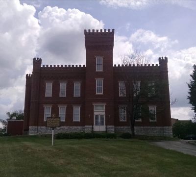
Frankfort in Franklin County, Kentucky — The American South (East South Central)
Kentucky State University
(Front)
School was chartered 1886; opened 1887 with three teachers and 55 students. The first state-supported institution of higher education for blacks, school gained funds from legislature for building and teachers, and from Frankfort city council for site and clearing of grounds. Kentucky State accredited as four year college in 1931; achieved university status in 1972. Over.
(Reverse)
John H. Jackson, before becoming first president of college, headed black teachers' association in Kentucky and promoted establishment of schools for instruction of black teachers. His efforts led to legislation founding college which became Kentucky State. He served 1887-98 and 1907-10. First permanent building, Jackson Hall, was named for him. Hall listed on National Register.
Erected 1984 by Kentucky Historical Society, Kentucky Department of Transportation. (Marker Number 1752.)
Topics and series. This historical marker is listed in these topic lists: African Americans • Education. In addition, it is included in the Historically Black Colleges and Universities, and the Kentucky Historical Society series lists. A significant historical year for this entry is 1886.
Location. 38° 12.16′ N, 84° 51.486′ W. Marker is in Frankfort, Kentucky, in Franklin County. Marker is on University Drive, on the right when traveling north. Marker is in front of Jackson Hall. Touch for map. Marker is in this post office area: Frankfort KY 40601, United States of America. Touch for directions.
Other nearby markers. At least 8 other markers are within walking distance of this marker. Mr. Taylor's Barber Shop (approx. 0.3 miles away); Oliver Percy Rood (approx. half a mile away); Remembering The Soldiers Of The War Of 1812 On Both Sides (approx. half a mile away); Beneath The Soil In Front Of You (approx. half a mile away); Here Lie The Remains of 250 Citizens Of Frankfort (approx. half a mile away); Frankfort (approx. half a mile away); Daniel Boone - Pioneer / Grave of Daniel Boone (approx. half a mile away); Frankfort Cemetery (approx. 0.6 miles away). Touch for a list and map of all markers in Frankfort.
Also see . . . Kentucky State University. (Submitted on June 17, 2015, by Dave Knoch of Scott County, Kentucky.)
Credits. This page was last revised on June 16, 2016. It was originally submitted on June 17, 2015, by Dave Knoch of Scott County, Kentucky. This page has been viewed 369 times since then and 23 times this year. Photos: 1, 2, 3. submitted on June 17, 2015, by Dave Knoch of Scott County, Kentucky. • Bill Pfingsten was the editor who published this page.
![Kentucky State University Marker [front]. Click for full size. Kentucky State University Marker [front] image. Click for full size.](Photos3/311/Photo311626.jpg?617201515300PM)
![Kentucky State University Marker [reverse]. Click for full size. Kentucky State University Marker [reverse] image. Click for full size.](Photos3/311/Photo311627.jpg?617201515400PM)
