Waterfront in Buffalo in Erie County, New York — The American Northeast (Mid-Atlantic)
A Changing Waterfront
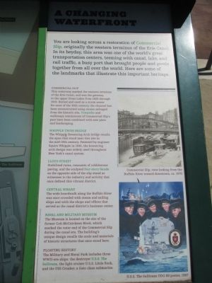
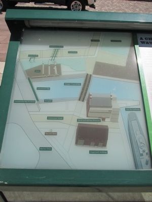
Commercial Slip.
This waterway marked the western terminus of the Erie Canal, and was the gateway to the upper Great Lakes from 1825 through 1918. Buried and used as a storm sewer for most of the 20th century, the channel has been reconstructed using stones salvaged from the historic site. Towpaths and walkways reminiscent of Commercial Slip's past have been combined with new piers and landscaping.
Whipple Truss Bridge.
The Whipple Bowstring Arch bridge recalls the span that stood near this site in the mid-19th century. Patented by the engineer Squire Whipple in 1841, the bowstring arch design was widely used throughout New York's canal system.
Lloyd Street. Stabilized ruins, remnants of cobblestone paving, and the scupted four-story facade on the opposite side of the slip stand as witnesses to the industry and activity that once defined this vibrant district.
Central Wharf.
The wide boardwalk along the Buffalo River was once crowded with steam and sailing ships and with the shops and offices that served as the canal district's business center.
Naval and Military Museum.
The Museum is located on the site of the former Coit-McCutcheon Block, which marked the outer end of the Commercial Slip during the canal era. The building's unique design recalls the scale and materials of historic structures that once stood here.
Floating History.
The Military and Naval Park includes three WWII-era ships: the destroyer U.S.S. The Sullivans, the light cruiser U.S.S. Little Rock, and the USS Croaker, a Gato class submarine.
Commercial Slip, view looking from the Buffalo River toward downtown, ca. 1870. Buffalo and Erie County Historical Society.
The U.S.S. The Sullivans DDG 68 poster, 1997. Courtesy of Lockheed Martin, original painting by Tom Freeman.
Topics and series. This historical marker is listed in this topic list: Waterways & Vessels. In addition, it is included in the Erie Canal series list. A significant historical year for this entry is 1825.
Location. 42° 52.666′ N, 78° 52.763′ W. Marker is in Buffalo, New York, in Erie County. It is in Waterfront. Marker is at the intersection of Marine Drive and Commercial Street, on the right when traveling east on Marine Drive. Touch for map. Marker is in this post office area: Buffalo NY 14202, United States of America. Touch for directions.
Other nearby markers. At least 8 other markers are within walking distance of this marker. USS Boston SSN703 (a few steps from this marker); Coit and Townsend’s “Red” Warehouse (a few steps from this marker); Lieutenant T. James (Jimmy) Crotty (within shouting distance of this marker); Lt. Col. Matt “The Ghost” Urban (within shouting distance of this marker); Erie Canalway National Heritage Corridor (within shouting distance of this marker); Buffalo - Queen City of the Lakes (within shouting distance of this marker); The Grand Canal (within shouting distance of this marker); William Wells Brown (within shouting distance of this marker). Touch for a list and map of all markers in Buffalo.
Related markers. Click here for a list of markers that are related to this marker. Markers for the Commercial Slip and U.S.S. The Sullivans
Credits. This page was last revised on February 16, 2023. It was originally submitted on June 20, 2015, by Anton Schwarzmueller of Wilson, New York. This page has been viewed 460 times since then and 10 times this year. Photos: 1, 2, 3, 4. submitted on June 20, 2015, by Anton Schwarzmueller of Wilson, New York.


