Marker Logo HMdb.org THE HISTORICAL
MARKER DATABASE
“Bite-Size Bits of Local, National, and Global History”
Old Montreal in Montréal in Communauté-Urbaine-de-Montréal, Québec — Central Canada (French-Canadian)
 

Paul de Chomedey de Maisonneuve

(1612-1671)


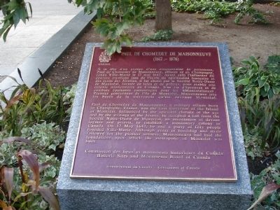
PAUL DE CHOMEDEY DE MAISONNEUVE Marker image. Click for full size.
Photographed By Roger Dean Meyer, August 18, 2007
1. PAUL DE CHOMEDEY DE MAISONNEUVE Marker
Inscription.  Ȃ la tête d’un groupe d’une cinquantaine de personnes, Paul de Chomedey de Maisonneuve, officier né en Champagne, fonda Ville-Marie le 17 mai 1642. Ayant subi l’influence du courant mystique issu de l’école de spiritualité française et des écrits des Jésuites, il fut choisi par la Société Notre-Dame de Montréal, formée de laïcs et de pêtres, pour établir une colonie missionnaire au Canada. Une vie d’épreuves et de combats épuisants commençait pour les Montréalistes. Premier gouverneur de l’île de Montréal, Maisonneuve jeta les bases de la metropole qu’est devenue Montréal.

Paul de Chomedey de Maisonneuve, a military officer born in Champagne, France , was the first Governor of the Island of Montréal. Influenced by the spiritual climate of the age and by the writings of the Jesuits, he accepted a call from the Notre-Dame de Montréal, an association of devout laymen and priests, to establish a missionary colony in Canada. On 17 May 1642, he and a party people founded Ville-Marie. Although years of hardship and strife followed for the pioneer settlers, Maisonneuve had laid the foundations upon which the metropolis
Paid Advertisement
Click on the ad for more information.
Please report objectionable advertising to the Editor.
Click or scan to see
this page online
of Montréal was built.
 
Erected by Commission des lieux et monuments historiques du Canada/Historic Sites and Monuments Board of Canada ( Gouvernment du Canada/Government of Canada).
 
Topics. This historical marker is listed in this topic list: Settlements & Settlers. A significant historical date for this entry is May 17, 1642.
 
Location. 45° 30.272′ N, 73° 33.429′ W. Marker is in Montréal, Québec, in Communauté-Urbaine-de-Montréal. It is in Old Montreal. Marker is at the intersection of Rue Notre-Dame Oest and Place d'Armes, on the right when traveling west on Rue Notre-Dame Oest. Located in the Place d' Armes on right side of Rue Notre-Dame Oest when traveling southwest. Across the street from the Notre Dame Basilica. Touch for map. Marker is in this post office area: Montréal QC H2Y 2W2, Canada. Touch for directions.
 
Other nearby markers. At least 8 other markers are within walking distance of this marker. La Basilique Notre-Dame / Notre-Dame Basilica (within shouting distance of this marker); History of Basilique Notre Dame de Montréal (within shouting distance of this marker); Jeanne Mance (about 180 meters away, measured in a direct line); Antoine Laumet de La Mothe, sieur de Cadillac (about 180 meters away); L’Ancien Édifice de la Douane / The Old Custom House (approx. 0.3 kilometers away); Aux origines de Montréal / The origins of Montréal
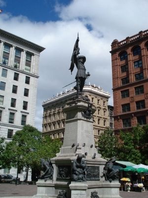
Paul de Chomedey de Maisonneuve Statue image. Click for full size.
Photographed By Roger Dean Meyer, August 18, 2007
2. Paul de Chomedey de Maisonneuve Statue
(approx. 0.3 kilometers away); Montréal’s Founders and First Colonists Monument (approx. 0.3 kilometers away); Saint-Laurent Boulevard (approx. 0.3 kilometers away). Touch for a list and map of all markers in Montréal.
 
Related marker. Click here for another marker that is related to this marker.
 
Also see . . .  Biography Chomedey du Maisonneuve. (Submitted on June 22, 2015, by Roger Dean Meyer of Yankton, South Dakota.)
 
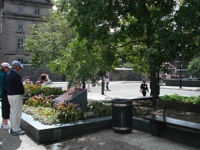
Paul de Chomedey de Maisonneuve Marker in the Place d' Armes image. Click for full size.
Photographed By Roger Dean Meyer, August 18, 2007
3. Paul de Chomedey de Maisonneuve Marker in the Place d' Armes
 
 
Credits. This page was last revised on August 12, 2023. It was originally submitted on June 22, 2015, by Roger Dean Meyer of Yankton, South Dakota. This page has been viewed 488 times since then and 27 times this year. Photos:   1, 2, 3. submitted on June 22, 2015, by Roger Dean Meyer of Yankton, South Dakota.
Share this page.  
Share on Tumblr
m=84612

CeraNet Cloud Computing sponsors the Historical Marker Database.
This website earns income from purchases you make after using our links to Amazon.com. We appreciate your support.
Paid Advertisement
Apr. 20, 2024