Missouri Highway History
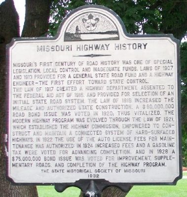
Missouri's first century of road history was one of special legislation, local control and inadequate funds. Laws of 1907 and 1913 provided for a general state road fund and a highway engineer - the first effort toward state control.
The law of 1917 created a highway department, assented to the Federal Aid Act of 1916, and provided for selection of an initial state road system. The law of 1919 increased the mileage and authorized state construction. A $60,000,000 road bond issue was voted in 1920; thus vitalized, the modern highway program was evolved through the law of 1921, which established the Highway Commission, empowered to construct and maintain a connected system of hard-surfaced highways. In 1922 the use of the auto license fees for maintenance was authorized: in 1924 increased fees and a gasoline tax were voted for advancing completion; and in 1928 a $75,000,000 bond issue was voted for improvement, supplementary roads, and completion of the highway program.
Erected 1932 by The State Historical Society of Missouri.
Topics. This historical marker is listed in this topic list: Roads & Vehicles. A significant historical year for this entry is 1907.
Location. 38° 41.455′ N, 93° 15.581′ W. Marker is in Sedalia, Missouri, in Pettis County. Marker
Other nearby markers. At least 8 other markers are within walking distance of this marker. Missouri: The Show Bee State (within shouting distance of this marker); Missouri State Highway System (within shouting distance of this marker); 4-H Building (within shouting distance of this marker); The Merci Boxcar (about 300 feet away, measured in a direct line); Poultry & Rabbit Building (about 300 feet away); Home Economics Building (about 500 feet away); Varied Industries Building (about 600 feet away); Old Smokie Frisco Engine (about 700 feet away). Touch for a list and map of all markers in Sedalia.
Also see . . .
1. Missouri State Highway System. Wikipedia entry (Submitted on June 4, 2022, by Larry Gertner of New York, New York.)
2. Interstate highway system began in Missouri 65 years ago this month. Metro Voice website entry, 2021 (Submitted on June 4, 2022, by Larry Gertner of New York, New York.)
Credits. This page was last revised on June 4, 2022. It was originally submitted on July 5, 2015, by William Fischer, Jr. of Scranton, Pennsylvania. This page has been viewed 342 times since then and 28 times this year. Photos: 1, 2. submitted on July 5, 2015, by William Fischer, Jr. of Scranton, Pennsylvania.

