Sedalia to Clifton City
Points of Interest
Clifton City, the next trail head east, is 11.7 miles by way of the old rail corridor. Due to an undeveloped section of trail immediately east of here, some travel over city streets is required, adding slightly to that distance. The grade is steadily downhill to Shaver Creek at milepost 218.6, the lowest point on this stretch at an elevation of 710 feet.
The designated route rejoins the historic MKT corridor at Boonville Street (milepost 225.8). This site was near the western terminus of Katy Trail State Park prior to 1999, when trail construction to Clinton was completed. Three-quarters of a mile beyond Griessen Road, the trail enters the Shaver Creek valley and continues alongside the permanent stream for the next five miles.
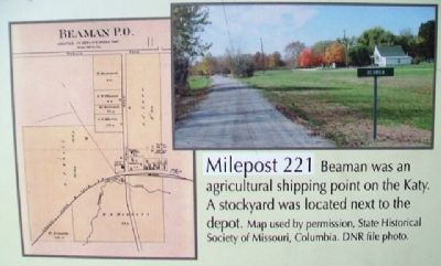
The rail community of Beaman and State Highway O are reached at milepost 221. The community was named after J.W. Beeman, appointed Pettis County Judge in 1865, and who once lived half a mile west of town. The community rarely consisted of more than a post office, depot and Christian church, all of which are gone.
As you near Clifton City, notice a change from the more open landscape of the Osage Plains to the rolling and occasionally rugged terrain of the Ozark Border. Pastures, crop lands and woods intermingle.
[Historical inset photo captions read]
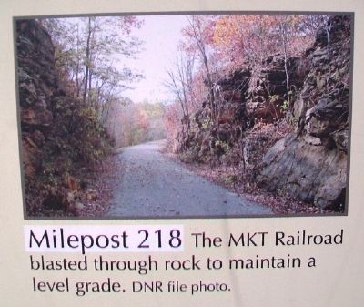
Milepost 218 The MKT
DNR file photo.
Milepost 221 Beaman was an agricultural shipping point on the Katy. A stockyard was located next to the depot.
Map used by permission, State Historical Society of Missouri, Columbia. DNR file photo.
Erected by Missouri State Parks.
Topics and series. This historical marker is listed in these topic lists: Entertainment • Railroads & Streetcars • Roads & Vehicles. In addition, it is included in the Katy Trail State Park series list. A significant historical year for this entry is 1999.
Location. 38° 42.446′ N, 93° 13.266′ W. Marker is in Sedalia, Missouri, in Pettis County. Marker is at the intersection of Thompson Avenue and 4th Street, on the left when traveling south on Thompson Avenue. Marker is at the Katy Trail kiosk at the Katy Depot. Touch for map. Marker is at or near this postal address: 600 East 3rd Street, Sedalia MO 65301, United States of America. Touch for directions.
Other nearby markers. At least 8 other markers are within walking distance of this marker. History of Sedalia (here, next to this marker); Sedalia Points of Interest (here, next to this marker); Sedalia to Green Ridge (here, next to this marker); Katy Trail State Park 25th Anniversary (a few steps from this marker); Katy Depot
Also see . . . Katy Trail State Park. (Submitted on July 11, 2015, by William Fischer, Jr. of Scranton, Pennsylvania.)
Credits. This page was last revised on June 16, 2016. It was originally submitted on July 11, 2015, by William Fischer, Jr. of Scranton, Pennsylvania. This page has been viewed 287 times since then and 16 times this year. Photos: 1, 2, 3, 4. submitted on July 11, 2015, by William Fischer, Jr. of Scranton, Pennsylvania.


