Near Guernsey in Platte County, Wyoming — The American West (Mountains)
Oregon Trail Ruts State Historic Site
The Trail West
— A Difficult Journey —
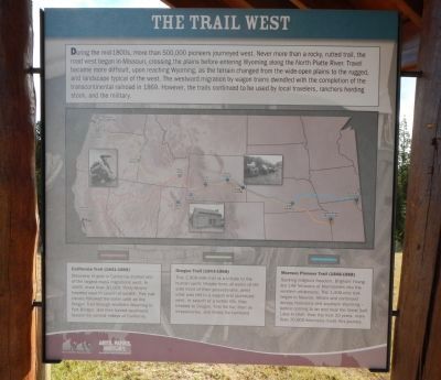
During the mid-1800s, more than 500,000 pioneers journeyed west. Never more than a rocky, rutted trail, the road west began in Missouri, crossing the plains before entering Wyoming along the North Plate River. Travel became more difficult, upon reaching Wyoming, as the terrain changed from the wide-open plains to the rugged, arid landscape typical of the west. The westward migration by wagon trains dwindled with the completion of the transcontinental railroad in 1869. However, the trails continued to be used by local travelers, ranchers herding stock, and the military.
California Trail (1841-1868)
Discovery of gold in California started one of the largest mass migrations west. In 1849, more than 30,000 "Forty-Niners" traveled west in search of wealth. This trail closely followed the same path as the Oregon Trail through southern Wyoming to Fort Bridger, and then turned southwest toward the central valleys of California.
Oregon Trail (1843-1868)
This 2,000-mile trail is a tribute to the human spirit. People from all walks of life sold most of their possessions, piled what was left in a wagon and journeyed west. In search of a better life, they headed to Oregon, first for fur, then as missionaries, and finally for farmland.
Mormon Pioneer Trail (1846-1868)
Seeking religious freedom, Brigham Young led 148 followers of Mormonism into the western wilderness. The 1,400-mile trek began in Nauvoo, Illinois and continued across Nebraska and southern Wyoming - before coming to an end near the Great Salt Lake in Utah. Over the next 20 years, more than 70,000 Mormons made this journey.
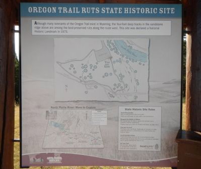
Although many remnants of the Oregon Trail exist in Wyoming, the four-foot deep tracks in the sandstone ridge above are among the best-preserved ruts along the route west. This site was declared a National Historic Landmark in 1975.
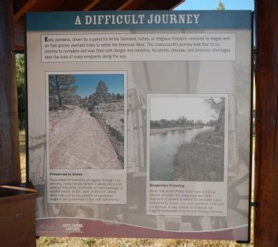
Early pioneers, driven by a quest for fertile farmland, riches, or religious freedom, ventured by wagon and on foot across trails to settle the American West. The cross-county journey took four to six months to complete and was filled with danger and hardship. Accidents, disease and provision shortages took the lives of many emigrants along the way.
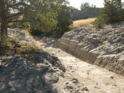
Preserved in Stone
Thousands of travelers struggled through this winding, rocky terrain before making camp just west of this point. Evidence of their passage is clearly visible at the crest of the hill, where deep ruts cut by the wheels of countless wagons are preserved in the soft sandstone.
Dangerous Crossing
While the North Plate River was a critical source of water for emigrants and their livestock, it posed a barrier to overland travel. Untamed by dams, the river could be swift and dangerous. It was easier to traverse the rugged landscape than to risk fording the river.
Erected by Wyoming State Parks & Cultural Resources.
Topics and series. This historical marker is listed in these topic lists: Roads & Vehicles • Settlements & Settlers. In addition, it is included in the Oregon Trail series list. A significant historical year for this entry is 1869.
Location. 42° 15.417′ N, 104° 44.928′ W. Marker is near Guernsey, Wyoming, in Platte County. Marker can be reached from Lucinda Rollins Road near South Guernsey Road, on the left when traveling west. Touch for map. Marker is in this post office area: Guernsey WY 82214, United States of America. Touch for directions.
Other nearby markers. At least 8 other markers are within walking distance of this marker. Oregon Trail Ruts (here, next to this marker); The United States Army and the Oregon Trail (a few steps from this marker); Forts, Stations, and Camps (a few steps from this marker); The US Army’s Role in Protecting the Oregon Trail is Best Described by the Soldiers (within shouting distance of this marker); a different marker also named Oregon Trail Ruts (about 400 feet away, measured in a direct line); Encampments in the Guernsey Area (about 400 feet away); Grave of Lucindy Rollins (approx. 0.3 miles away); Laramie Peak (approx. 0.9 miles away). Touch for a list and map of all markers in Guernsey.
More about this marker. This marker is found at the kiosk at the Oregon Trail Ruts parking lot.
Credits. This page was last revised on June 16, 2016. It was originally submitted on July 22, 2015, by Barry Swackhamer of Brentwood, California. This page has been viewed 534 times since then and 19 times this year. Photos: 1, 2, 3, 4. submitted on July 22, 2015, by Barry Swackhamer of Brentwood, California. • Andrew Ruppenstein was the editor who published this page.


