Quindaro Bluffs in Kansas City in Wyandotte County, Kansas — The American Midwest (Upper Plains)
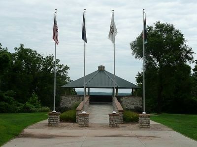
Quindaro Ruins Archaeological Park
Inscription.
West Inscription:
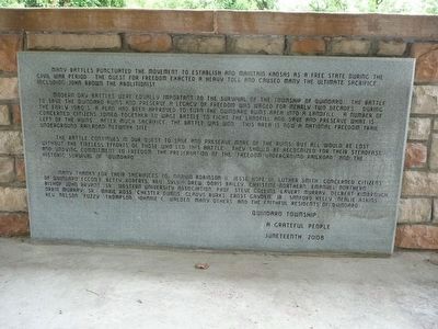
Many battles punctuated the movement to establish and maintain Kansas as a free state during the Civil War period. The quest for freedom exacted a heavy toll and caused many the ultimate sacrifice including John Brown the abolitionist.
Modern day battles were equally important to the survival of the township of Quindaro. The battle to save the Quindaro ruins and preserve a legacy of freedom was waged for nearly two decades. During the early 1980’s a plan had been approved to turn the Quindaro ruins area into a landfill. A number of concerned citizens joined together to wage battle to fight the landfill and save and preserve what is left of the ruins. After much sacrifice the battle was one. This area is now a national freedom trails underground railroad network site.
The battle continues in our quest to save and preserve more of the ruins but all would be lost without the tireless efforts of those who led this battle. They should be recognized for their steadfast and undying commitment to freedom. The preservation of the “Freedom Underground Railroad” and the historic survival of Quindaro.
Many thanks for their sacrifices to Marvin Robinson II, Jesse Hope III, Luther Smith, Concerned Citizens of Quindaro (CCOQ), Betty Roberts, Rev. Sylvia Drew, Doris Bailey, Christine Northern, Emanuel Northen, Bishop John Bryant, Sr., Western University Association Prof. Steve Collins , Lavert Murray, Delbert Kimbrough, Orrin Murray, SR., Marie Ross, Chester Owens, Gladys Burks, Ernest Gaydon, Jr., Sanford Kelly, Nealie Atkins, Rev. Nelson (“Fuzzy”) Thompson, Johnnie C. Walden, many others and the faithful residents of Quindaro.
Quindaro Township
A grateful people
Juneteenth, 2008
East Inscription:
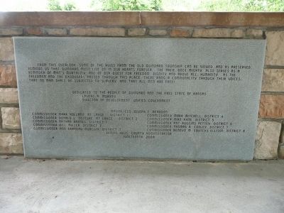
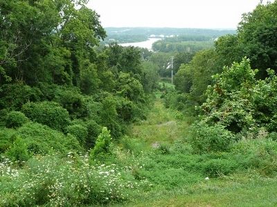
From this overlook some of the ruins from Old Quindaro township can be viewed and as preserved reminds us that Quindaro must live on in our hearts forever. The area once mighty, also serves as a reminder of man’s humanity as the freedman and the exodusers passed through this place there rang a commonality through their voices that no man shall be subjected to slavery and that all men are free!
Dedicated to the people of Quindaro and the Free State of Kansas
Lavert A. Murray
Director of Development, Unified Government
Mayor/CEO Joseph F. Reardon
Commissioner Mark Holland at Large District 1
Commissioner Donald D. L. Deseure at Large District 2
Commissioner Nathan Barnes District 1
Commissioner Bill Miller District 2
Commissioner Ann Brandau-Murguia District 3
Commissioner Mark Mitchell District 4
Commissioner Mike Kane District 5
Commissioner
Pat Huggins Petty District 6
Commissioner Thomas R Cooley District 7
Commissioner Benoyd M (Butch) Ellison District 8
Dennis Hayes County Administrator
Juneteenth 2008
Erected 2008.
Topics. This historical marker is listed in these topic lists: Abolition & Underground RR • African Americans • Civil Rights • Settlements & Settlers • War, US Civil. A significant historical year for this entry is 2008.
Location. 39° 9.084′ N, 94° 39.548′ W. Marker is in Kansas City, Kansas, in Wyandotte County. It is in Quindaro Bluffs. Marker is on North 27th Street. Touch for map. Marker is in this post office area: Kansas City KS 66104, United States of America. Touch for directions.
Other nearby markers. At least 8 other markers are within 3 miles of this marker, measured as the crow flies. Quindaro, Kansas (approx. 0.2 miles away); John Brown (approx. 0.2 miles away); Western University (approx. 0.2 miles away); Mather Hall - Kansas City University (approx. 1.7 miles away); Renner Village Site (approx. 2.9 miles away in Missouri); Park Bank - Farmers Exchange Bank (approx. 2.9 miles away in Missouri); Eliza Burton Conley (approx. 3.1 miles away); Helena Conley (approx. 3.1 miles away). Touch for a list and map of all markers in Kansas City.
Also see . . .
1. Quindaro, Kansas. The Civil War on the Western Border site's page on Quintaro:…Helping slaves escape was a federal crime, and because of the secret nature of the Underground Railroad there is a paucity of written evidence for Quindaro’s role in helping slaves escape from Missouri. In her memoirs, however, Clarina Nichols recounted the town’s role in a few tales of what she described as “emancipation without proclamation.” Oral histories and local lore further support the contention that Quindaro was a way station on the Underground Railroad.
Quindaro had an antebellum free African American community, and some residents of the town, local farmers, and the Wyandotte Indians networked to help slaves escape into Kansas. At times, they confronted slave catchers directly and refused to cooperate in returning runaways to their owners. More often they secretly and quietly fed, hid, and sheltered the escapees on their journey to freedom. The nearby Quindaro-Parkville Ferry is said to have made clandestine night runs, causing the proslavery side to sink it in frustration in 1861. Undeterred in their pursuit of freedom, some of the enslaved people boldly walked across the Missouri River to freedom in Kansas during the unusually cold winter of 1862 when the ice formed a solid sheet. (Submitted on July 27, 2015.)
2. Quindaro, Kansas Territory (1857-1862)
. Black Past's page on Quindaro: Quindaro was an abolitionist town on the border between the slave state of Missouri and free state settlers in Territorial Kansas. By its existence, Quindaro undermined the attempted blockade of the Missouri River by proslavery advocates against additional free state supporters flowing into Kansas. Quindaro was located on the lands of the Wyandot Tribe which was forced to move to Kansas Territory in 1844 on the heel of the Trail of Tears. The Wyandot had been sympathetic to abolitionism and active in the underground railroad in their native Ohio. When they arrived in Kansas Territory their tribal council immediately instituted anti-slavery laws, the first such laws in Kansas Territory. (Submitted on July 27, 2015.)
Credits. This page was last revised on February 10, 2023. It was originally submitted on July 27, 2015, by Michael W. Kruse of Kansas City, Missouri. This page has been viewed 831 times since then and 17 times this year. Photos: 1, 2, 3, 4. submitted on July 27, 2015, by Michael W. Kruse of Kansas City, Missouri. • Andrew Ruppenstein was the editor who published this page.


