Old Westport in Kansas City in Jackson County, Missouri — The American Midwest (Upper Plains)
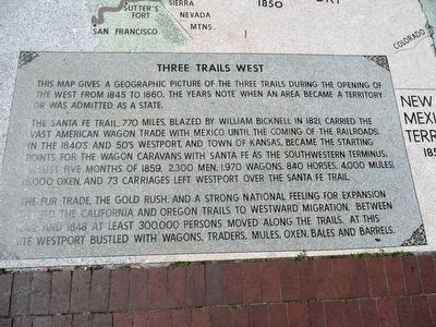
Three Trails West
Inscription.
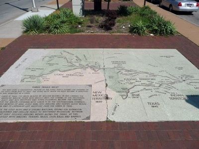
This map gives a geographic picture of the three trails during the opening of the west from 1845 to 1860. The years note when an area became a territory or was admitted as a state.
The Santa Fe Trail, 770 miles, blazed by William Bicknell in 1821, carried the vast American wagon trade with Mexico until the coming of the railroad in the 1840’s and 50’s Westport, and the Town of Kansas, became the starting points for the wagon caravans with Santa Fe as the southwestern terminus. In just five months of 1859, 2,300 men, 1,970 wagons, 840 horses, 4,000 mules, 15,000 oxen, and 73 carriages left Wesport over the Santa Fe Trail.
The fur trade, the gold rush, and a strong national feeling for expansion, opened the California and Oregon Trails to westward immigration between 1842 and 1848 at least 300,000 persons moved along the trails. At this site Wesport bustled with Wagons, traders, mules, oxen, bales and barrels.
Erected 1987 by Native Sons, Kansas City, Missouri and the Westport Historical Society.
Topics. This historical marker is listed in these topic lists: Industry & Commerce • Railroads & Streetcars • Roads & Vehicles • Settlements & Settlers. A significant historical year for this entry is 1845.
Location. 39° 3.21′ N, 94° 35.43′ W. Marker is in Kansas City, Missouri, in Jackson County. It is in Old Westport. Marker is at the intersection of Broadway Boulevard and Westport Road, in the median on Broadway Boulevard. Touch for map. Marker is in this post office area: Kansas City MO 64111, United States of America. Touch for directions.
Other nearby markers. At least 8 other markers are within walking distance of this marker. Alexander Majors (a few steps from this marker); John Calvin McCoy (a few steps from this marker); James Bridger (a few steps from this marker); West Port, Missouri (within shouting distance of this marker); Original Site of Harris House (about 300 feet away, measured in a direct line); Action Before Westport (about 300 feet away); The Albert G. Boone Store (about 400 feet away); The French and the Santa Fe Trail (about 400 feet away). Touch for a list and map of all markers in Kansas City.
Credits. This page was last revised on February 10, 2023. It was originally submitted on August 17, 2015, by Michael W. Kruse of Kansas City, Missouri. This page has been viewed 582 times since then and 64 times this year. Photos: 1, 2. submitted on August 17, 2015, by Michael W. Kruse of Kansas City, Missouri. • Bill Pfingsten was the editor who published this page.

