Near Avalon in Baltimore County, Maryland — The American Northeast (Mid-Atlantic)
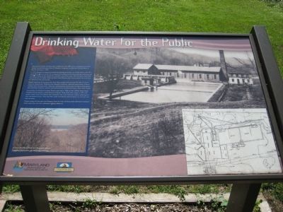
Drinking Water for the Public
In 1910, Bloede's company purchased the abandoned Avalon Iron & Nail Works and build a water filtration plant on the site. A large brick building housed the pumping machinary, and concrete holding ponds settle dirt and debris out of the ater. The remnants of the holding ponds are still visible. Water purified at the filtration plant was pumped into southwestern Batlimore City and County.
Bloede organized his company at a time when people were learning the value of natural resource conservation. Following the industrial revolution, resources were scarce. Citizens needed clean drinking water, industries needed power, towns were turning to water-generated electricity. Pollution, erosion, and sedimentation threatened regular clean water supply.
Fortunately, the Maryland Forestry Board organized in 1906 to help address these issues. Patapsco Forest Resever, which became Patapsco Valley State Park, began in 1907 with goals to plant trees and reforest the reverbanks. Tree roots hold soil in place, reducing erosion and sedimentation. Trees also filter water and absorb pullutants that run into the river with rainwater.
People today still rely upon the Patapsco River for clean drinking water. Baltimore residents drink water from the river collected in Liberty Reservoir.
Text with lower left photo: A view of Liberty Dam and Reservoir which supplies fresh water for Baltimore County.
Erected by Maryland Department of Natural Resources, Chesapeake Bay Gateways Network.
Topics. This historical marker is listed in these topic lists: Charity & Public Work • Environment • Industry & Commerce. A significant historical year for this entry is 1909.
Location. 39° 13.649′ N, 76° 43.219′ W. Marker is near Avalon, Maryland, in Baltimore County. Marker can be reached from the intersection of Washington Boulevard (U.S. 1) and South Street. Marker is within the Patapsco Valley State Park - Avalon area, on the northern side of the Patapsco River. Marker is about 200 yards along footpath from Avalon Visitor Center parking lot which is just under 1 mile from the park gate building. Entrance to PVSP is about 300 feet north of the US 1 - South Street intersection. Touch for map. Marker is in this post office area: Halethorpe MD 21227, United States of America. Touch for directions.
Other nearby markers. At least 8 other markers are within walking distance of this marker. The Baltimore County Water and Electric Company (within shouting distance of this marker); Forging Freedom and Nails (within shouting distance of this
marker); Powering the Patapsco Valley's Industries (about 400 feet away, measured in a direct line); A Place For Progress (about 400 feet away); Iron Builds America (about 400 feet away); Elkridge Landing (about 700 feet away); Patapsco Valley State Park (about 800 feet away); The C.C.C. Builds Our Park (approx. 0.2 miles away). Touch for a list and map of all markers in Avalon.
Credits. This page was last revised on January 10, 2020. It was originally submitted on July 5, 2008, by F. Robby of Baltimore, Maryland. This page has been viewed 1,303 times since then and 21 times this year. Photos: 1, 2. submitted on July 5, 2008, by F. Robby of Baltimore, Maryland.

