Bayeux in Calvados, Normandy, France — Western Europe
Un édifice du Xe siècle
A 10th Century Building
— Bayeux, la Qualité a ses Racines —
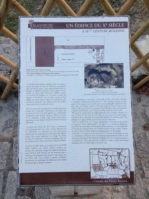
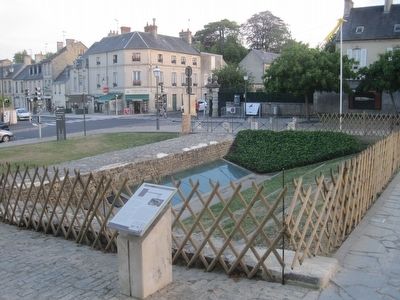
La fouille archéologique pratiquée dans ce secteur a permis de mettre au jour un bâtiment rectangulaire date des IXe-Xe siècles, situé perpendiculairement au rempart et utilisant ce dernier comme pignon à l’est. Etudié sur trois cotes seulement, l’édifice mesure 9,70 mètres de longueur sur au moins 5 mètres de largeur. A l’intérieur, son sol était constitué d’un dallage de petites pierres plates (ici évoqué par une restitution moderne), des enduits peints de couleur rouge recouvrant une partie des murs.
Rien ne permet de connaitre avec certitude la fonction initiale de ce bâtiment. Néanmoins, sa surface (au minimum 45 m2) et le soin apporté à sa construction témoignent d’un habitat luxueux. Place au chevet de la cathédrale, il peut s’agir d’une construction appartenant à son clergé et destinée à abriter l’un de ses dignitaires.
A partir du milieu du XIIe siècle, le bâtiment est mentionné dans les textes comme fabrique de la cathédrale. La fabrique est une institution pourvoyant à la construction et à l’entretien des édifices sacres. Elle prend également en charge les objets de culte, les vêtements et les livres liturgiques. Elle tire ses ressources des dimes, des dons et legs des fidèles.
A partir du XIIIe siècle, et ce jusqu’à la fin du XVIIe siècle, l’édifice est utilisé comme fonderie de cloches. De nombreux vestiges de moules de diamètres varies (0,50 à 2,50 mètres) ont été reconnus tant à l’intérieur du bâtiment que dans la cour située sur son flanc sud. Leur fouille a permis d’étudier précisément les techniques de fabrication des cloches du Moyen Age à l’époque moderne.
The archaeological excavations carried out in this sector have revealed a rectangular building dating from the 9th - 10th centuries, situated at right angles to the ramparts and using the latter as an eastern gable. Studied on only three sides, the building measures 9.70 metres long by at least 5 metres wide. Inside, its floor was formed of a pavement of small flat stones (here represented by a modern reconstruction), and red paint coating covered part of the wells.
We cannot be certain about the original function of this building. However, its area (at least 45 m2) and the care taken in its construction would suggest a luxurious home. Positioned at the side of the cathedral, the building might have belonged to its clergy and been used to house one of its dignitaries.
From the middle of the 12th century, the building is mentioned in documents as being part of the cathedral fabric. The fabric is an institution designed to provide for the construction and the upkeep of holy buildings. It is also responsible for keeping the liturgical objects the vestments and the liturgical books. It draws its resources from the tithes, donations and legacies given by the faithful.
From the 13th century up to the end of the 17th century, the building was used as a bell foundry. Numerous traces of moulds of varying diameters (0.50 to 2.50 metres have been found, both inside the building and in the courtyard situated on its southern side. Their excavation has enabled us to study in detail bell-making techniques from the Middle Ages to the present day.
Erected by La ville de Bayeux.
Topics and series. This historical marker is listed in this topic list: Notable Buildings. In addition, it is included in the France - Bayeux - Circuit du Vieux Bayeux series list.
Location. 49° 16.508′ N, 0° 42.17′ W. Marker is in Bayeux, Normandie (Normandy), in Calvados. Marker can be reached from the intersection of Rue Larcher and Rue L L le Forestier. Touch for map. Marker is in this post office area: Bayeux, Normandie 14400, France. Touch for directions.
Other nearby markers. At least 8 other markers are within walking distance of this marker.
Le Rempart Gallo-Roman (here, next to this marker); Les Abords du Chevet de la Cathédrale (a few steps from this marker); Le Doyen du Chapitre (within shouting distance of this marker); 50th Northumbrian Division Memorial (within shouting distance of this marker); Le palais Episcopal (within shouting distance of this marker); L'Esplanade Flachat (about 120 meters away, measured in a direct line); Autour des Augustines (about 150 meters away); L'Aure (about 180 meters away). Touch for a list and map of all markers in Bayeux.
More about this marker. The caption on the marker's top drawing reads:
Edifice du Xe siecle adosse au rempart
D’apres le releve de L. Gohin – Service Departemental d’Archeologie du Calvados (Avril 2003)
10th century building standing against the ramarts
According to L. Gobin’s report – Calvados Departmental Archaeology Division (April 2003)
The caption on the marker's top photograph reads:
Moules à cloche mis au jour dans la cour de l’édifice en cours de fouille
Bell moulds uncovered in the building’s courtyard during the excavations.
Additional keywords. Un édifice du Xe siècle
Credits. This page was last revised on September 10, 2018. It was originally submitted on September 25, 2015, by Kevin W. of Stafford, Virginia. This page has been viewed 262 times since then and 2 times this year. Photos: 1, 2, 3. submitted on September 25, 2015, by Kevin W. of Stafford, Virginia. • Andrew Ruppenstein was the editor who published this page.


