Near Oakfield in Worth County, Georgia — The American South (South Atlantic)
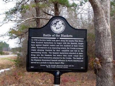
Battle of the Blankets
Erected 2004 by Georgia Historical Society and the Worth County Historical Society. (Marker Number 159-1.)
Topics and series. This historical marker is listed in these topic lists: Native Americans • Wars, US Indian. In addition, it is included in the Georgia Historical Society series list. A significant historical year for this entry is 1702.
Location. 31° 47.863′ N, 83° 57.447′ W. Marker is near Oakfield, Georgia, in Worth County. Marker is at the intersection of Georgia-Florida Parkway (State Highway 300) and Jones Place (State Route 300), on the right when traveling north on Georgia-Florida Parkway. Touch for map. Marker is in this post office area: Oakfield GA 31772, United States of America. Touch for directions.
Other nearby markers. At least 8 other markers are within 12 miles of this marker, measured as the crow flies. Fort Early (approx. 4.6 miles away); The Southern People (approx. 4.7 miles away); Chehaw (approx. 10.2 miles away); Georgia Veterans Memorial State Park (approx. 11.1 miles away); Veterans of Foreign Wars Group Camp (approx. 11.1 miles away); Spanish-Indian Battle (approx. 11.6 miles away); a different marker also named Georgia Veterans Memorial State Park (approx. 12 miles away); Camp Safety Patrol (approx. 12 miles away).
Credits. This page was last revised on June 16, 2016. It was originally submitted on July 8, 2008, by David Seibert of Sandy Springs, Georgia. This page has been viewed 2,941 times since then and 35 times this year. Photo 1. submitted on July 8, 2008, by David Seibert of Sandy Springs, Georgia. • Kevin W. was the editor who published this page.
Editor’s want-list for this marker. A wide shot of the marker and its surroundings. • Can you help?
