Near Big Horn in Sheridan County, Wyoming — The American West (Mountains)
Community Service Routes
Stagecoach Roads in Sheridan County
Inscription.
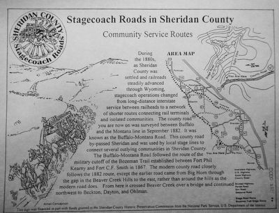
During the 1880s, as Sheridan County was settled and railroads steadily advanced through Wyoming, stagecoach operations changed from long-distance interstate service between railheads to a network of shorter routes connecting rail terminal and isolated communities. The county road you are now on was surveyed between Buffalo and the Montana line in September 1882. It was known as the Buffalo-Montana Road. This county road by-passed Sheridan and was used by local stage lines to connect several outlying communities in Sheridan County.
The Buffalo-Montana Road followed the route of the military cutoff of the Bozeman Trail established between Fort Phi Kearny and Fort C.F. Smith in 1867. The modern county road closely follows the 1882 route, except the earlier road came from Big Horn through the gap in the Beaver Creek Hills to the east, rather than around the hills as the modern road does, From here it crossed Beaver Creek over a bridge and continued northwest to Beckton, Dayton, and Ohlman.
Erected by Sheridan County Historic Preservation Commission.
Topics. This historical marker is listed in this topic list: Roads & Vehicles.
Location. Marker has been reported missing. It was located near 44° 41.035′ N, 107° 4.84′ W. Marker was near Big Horn, Wyoming, in Sheridan County. Marker could be reached from Beaver Creek Road (County Route 87) near Bear Gulch Road. Touch for map. Marker was at or near this postal address: 361 Beaver Creek Road, Big Horn WY 82833, United States of America. Touch for directions.
Other nearby markers. At least 8 other markers are within 10 miles of this location, measured as the crow flies. Bozeman Trail (approx. 4.3 miles away); Bozeman Trail Blacksmith Shop (approx. 4.4 miles away); Big Horn Blacksmith Shop (approx. 4.4 miles away); a different marker also named Bozeman Trail (approx. 4.7 miles away); a different marker also named The Bozeman Trail (approx. 8˝ miles away); Sheridan (approx. 8˝ miles away); Rock Creek to Montana Stage Line (approx. 9.7 miles away); The Pipe of Peace (approx. 9.7 miles away). Touch for a list and map of all markers in Big Horn.
More about this marker. After driving past the recorded location of this marker, this correspondent concludes the marker is missing.
This plaque is one of six "Stagecoach Roads in Sheridan County" markers.
Credits. This page was last revised on June 16, 2016. It was originally submitted on December 10, 2015, by Barry Swackhamer of Brentwood, California. This page has been viewed 258 times since then and 7 times this year. Photo 1. submitted on December 10, 2015, by Barry Swackhamer of Brentwood, California.
Editor’s want-list for this marker. Photographs of the original marker. • Can you help?
