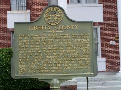
Hinesville in Liberty County, Georgia — The American South (South Atlantic)
Liberty County
Erected 1956 by Georgia Historical Commission. (Marker Number 089-6.)
Topics and series. This historical marker is listed in this topic list: Notable Places. In addition, it is included in the Georgia Historical Society series list. A significant historical date for this entry is May 20, 1778.
Location. 31° 50.858′ N, 81° 35.727′ W. Marker is in Hinesville, Georgia, in Liberty County. Marker is on Ct Street West near Commerce Street. Marker is in front of the courthouse. Touch for map. Marker is in this post office area: Hinesville GA 31313, United States of America. Touch for directions.
Other nearby markers. At least 8 other markers are within walking distance of this marker. Liberty County Confederate Monument (here, next to this marker); Bradwell Park (within shouting distance of this marker); Fort Morris Cannon (within shouting distance of this marker); Charlton Hines House (about 400 feet away, measured in a direct line); Hinesville Methodist Church (about 500 feet away); The Bacon-Fraser House (about 500 feet away); Old Liberty County Jail (approx. 0.2 miles away); Skirmish at Hinesville (approx. half a mile away). Touch for a list and map of all markers in Hinesville.
Credits. This page was last revised on January 14, 2021. It was originally submitted on July 16, 2008, by Mike Stroud of Bluffton, South Carolina. This page has been viewed 1,187 times since then and 21 times this year. Photos: 1, 2. submitted on July 16, 2008, by Mike Stroud of Bluffton, South Carolina. • Christopher Busta-Peck was the editor who published this page.

