Bayport in Hernando County, Florida — The American South (South Atlantic)
The Bayport Area Before Human Occupation/Bayport's First People
Inscription.
(side 1)
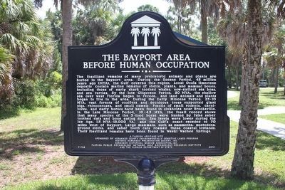
The fossilized remains of many prehistoric animals and plants are buried in the Bayport area. During the Eocene Period, 45 million years ago (MYA), the Gulf covered this region. Local Ocala limestone deposits contain marine remains of shells, plants, and mammal bones, including those of early shark toothed whales, now-extinct sea boas, and sea turtles. By the late Oligocene Period, 30 MYA, the shallow sea over west Florida began to recede, and land animals and plants began to live in the area. During the Early Miocene Period, 25-10 MYA, vast forests of conifers and deciduous trees supported giant pigs, rhinoceros, and small camels. Fossils of small rodents, carnivores, and early horses have been found in sinkholes near Brooksville. In the Late Miocene Period, 10-4.5 MYA, the fossil record shows that many species of the 3-toed horse were hunted by false saber toothed cats and bone eating dogs. Sea levels were lower during the Ice Age, 1.5 MYA-13,000 YA, and the Gulf's coast receded to 70 miles west of Bayport. Large mammals, such as mammoths, mastodons, ground sloths, and saber tooth cats roamed these coastal lowlands. Their fossilized remains have been found in Weeki Wachee Springs.
(side 2)
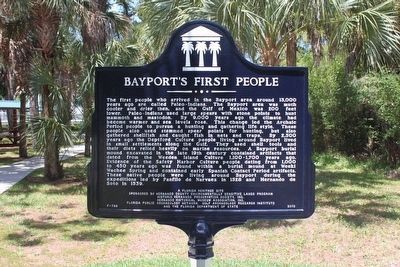
The first people who arrived in the Bayport area around 13,000 years ago are called Paleo-Indians. The Bayport area was much cooler and drier then, and the Gulf of Mexico was 200 feet lower. Paleo-Indians used large spears with stone points to hunt mammoth and mastodon. By 9,000 years ago the climate had become warmer and sea levels rose. This change led the Archaic Period people to pursue a hunting and gathering life style. These people also used stemmed spear points for hunting, but also gathered shellfish and caught fish in nets and traps. By 2,500 years ago the Deptford Culture people living around Bayport lived in small settlements along the Gulf. They used shell tools and their diets relied heavily on marine resources. A Bayport burial mound excavated in the late 19th century contained artifacts that dated from the Weeden Island Culture 1,100-1,700 years ago. Evidence of the Safety Harbor Culture people dating from 1,000 to 450 years ago was found within a burial mound at Weeki Wachee Spring and contained early Spanish Contact Period artifacts. These native people were living around Bayport during the expeditions led by Panfilo de Narvaez in 1528 and Hernando de Soto in 1539.
Erected 2013 by Hernando County Environmentally Sensitive Lands Program, Historic Hernando Preservation Society, Inc., Hernando Historical Museum Association, Inc., Florida Public Archeology Network, Gulf Archeology Research Institute and the Florida Department of State. (Marker Number F-788.)
Topics. This historical marker is listed in these topic lists: Anthropology & Archaeology • Native Americans • Paleontology.
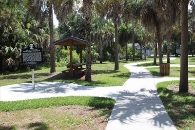
Location. 28° 32.152′ N, 82° 39.076′ W. Marker is in Bayport, Florida, in Hernando County. Marker can be reached from Cortez Boulevard (County Road 550) 6˝ miles west of Commercial Way (U.S. 19). Marker is in the Bayport Park picnic area near the boat ramp parking lot, at the end of Cortez Blvd, west of Weeki Wachee State Park. Touch for map. Marker is at or near this postal address: 4140 Cortez Blvd, Spring Hill FL 34607, United States of America. Touch for directions.
Other nearby markers. At least 8 other markers are within 13 miles of this marker, measured as the crow flies. Bayport's Early Historic Period/Post Civil War Era (a few steps from this marker); Bayport in the Civil War/The Battle of Bayport (within shouting distance of this marker); Bayport (about 600 feet away, measured in a direct line); Aripeka Historic District (approx. 7.2 miles away); Town of Centralia (approx. 8 miles away); Veterans Memorial Flag Pole
(approx. 9.1 miles away); Hudson Area Veterans Memorial (approx. 12.1 miles away); Hudson Cemetery (approx. 12.1 miles away). Touch for a list and map of all markers in Bayport.
Related marker. Click here for another marker that is related to this marker.
Credits. This page was last revised on August 6, 2017. It was originally submitted on March 26, 2016, by Tim Fillmon of Webster, Florida. This page has been viewed 706 times since then and 76 times this year. Photos: 1, 2, 3. submitted on March 26, 2016, by Tim Fillmon of Webster, Florida. • Bernard Fisher was the editor who published this page.


