Whaleyville in Suffolk, Virginia — The American South (Mid-Atlantic)
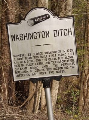
Washington Ditch
Erected by Camp MFG Co.
Topics and series. This historical marker is listed in these topic lists: African Americans • Colonial Era • Man-Made Features • Waterways & Vessels. In addition, it is included in the Former U.S. Presidents: #01 George Washington series list.
Location. 36° 39′ N, 76° 33.671′ W. Marker is in Suffolk, Virginia. It is in Whaleyville. Marker can be reached from the intersection of White Marsh Road and Washington Ditch Road, on the left when traveling south. Touch for map. Marker is at or near this postal address: 3076 White Marsh Road, Suffolk VA 23434, United States of America. Touch for directions.
Other nearby markers. At least 8 other markers are within 6 miles of this marker, measured as the crow flies. Dismal Town (approx. 0.4 miles away); Jericho Ditch (approx. 4˝ miles away); Nansemond Collegiate Institute (approx. 5.3 miles away); Nansemond Industrial Institute (approx. 5.3 miles away); Mr. Peanut (approx. 5.4 miles away); Booker T. Washington High School (approx. 5˝ miles away); President's Days Plaque (approx. 5.6 miles away); Obici-Oderzo Fountain Marker (approx. 5.6 miles away). Touch for a list and map of all markers in Suffolk.
Credits. This page was last revised on February 1, 2023. It was originally submitted on March 31, 2016, by Kathy Richardson of Glen Allen, Virginia. This page has been viewed 798 times since then and 85 times this year. Photo 1. submitted on March 31, 2016, by Kathy Richardson of Glen Allen, Virginia. • Bernard Fisher was the editor who published this page.
