Guatemala City in Guatemala Department, — Central America
Ceremonial Area
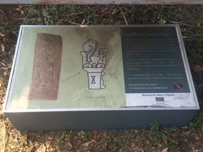
Área de Ceremonias
Kaminaljuyú es un Lugar Sagrado donde se realizan rituales para comunicarse con el Ajaw Creador y Formador. Aquí se realizan ceremonias de agradecimiento, petición, para curar enfermedades, propiciatorias de eventos, celebraciones y conmemoración en los días especiales del calendario Maya.
En la zona Maya estas celebraciones se observan en estelas, escenas pintadas en murales y objetos de cerámicas, códices y entierros encontrados en excavaciones arqueológicas.
La espiritualidad Maya es tangible y trascendente y Kaminaljuyu es un espacio Sagrado propicio para expresarse.
"Se agradece no tomar fotografias a las ceremonias"
Pie de dibujo: Detalle incensario
Ceremonial Area
Kaminaljuyú is a sacred place where rituals are performed to communicate with the Creator and Maker Ajaw. Here ceremonies are made for thanksgiving, petitions, to cure diseases, celebration of events and for commemoration of the special days of the Mayan calendar.
In the Mayan world, these celebrations are observed in stelae, scenes painted in murals and on ceramic objects, codices and burials found in archaeological excavations.
Maya spirituality is tangible and transcendent and Kaminaljuyu is a sacred space conducive to expressing spirituality.
Thank you for not taking photographs of the ceremonies
Caption: Incense burner detail
Erected by Ministerio de Cultura y Deportes, Instituto de Antropología y Historia.
Topics. This historical marker is listed in these topic lists: Anthropology & Archaeology • Churches & Religion • Native Americans.
Location. 14° 37.94′ N, 90° 32.876′ W. Marker is in Guatemala City, Guatemala (Guatemala Department). Marker can be reached from 11a Avenidad, Zona 11. The marker is at the Kaminaljuyú Archaeological Site in Guatemala City. Touch for map. Marker is at or near this postal address: 23a Avenidad, Guatemala City, Guatemala 01011, Guatemala. Touch for directions.
Other nearby markers. At least 8 other markers are within 3 kilometers of this marker, measured as the crow flies. The Acropolis at Kaminaljuyú (about 120 meters away, measured in a direct line); La Palangana Building Complex (about 150 meters away); Monuments in La Palangana (about 180 meters away); The Mirador Canal (approx. 1.5 kilometers away); Jorge Toriello Garrido (approx. 2.1 kilometers away);
Tomb of Justo Rufino Barrios (approx. 2.2 kilometers away); 100th Anniversary of the Paulist Fathers in Guatemala (approx. 3.1 kilometers away); José Luis de León Díaz (Luis de Lión) (approx. 3.2 kilometers away). Touch for a list and map of all markers in Guatemala City.

Photographed By J. Makali Bruton, March 11, 2016
3. Nearby C-II-3 Mound marker
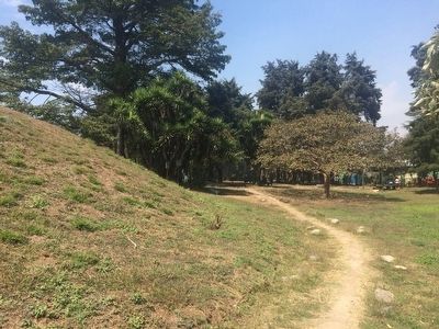
On the other side of the temple mound where the Ceremonial Area marker is located is this explanatory marker about the mound:
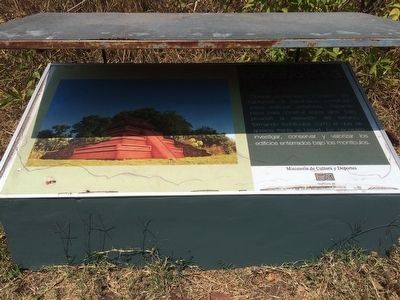
Montículo C-II-3
Durante el Preclásico y Clásico, habitantes de Kaminaljuyu construían sobre edificios anteriores, nivelando pisos para construir sobre ellos. Esto provocó la elevación del terreno, formando montículos como el que se aprecia frente a Usted. Es necesario investigar, conservar y valorizar los edificios enterrados bajo los montículos.
English translation:
Temple Mound C-II-3
During the Pre-Classic and Classic periods the inhabitants of Kaminaljuyu built over previous buildings, leveling the surface in order to build new areas. This increased the elevation of the site, resulting in mounds like the one in front of you here. Its necessary to investigate, conserve and value the buildings buried under the mounds.
Durante el Preclásico y Clásico, habitantes de Kaminaljuyu construían sobre edificios anteriores, nivelando pisos para construir sobre ellos. Esto provocó la elevación del terreno, formando montículos como el que se aprecia frente a Usted. Es necesario investigar, conservar y valorizar los edificios enterrados bajo los montículos.
Temple Mound C-II-3
During the Pre-Classic and Classic periods the inhabitants of Kaminaljuyu built over previous buildings, leveling the surface in order to build new areas. This increased the elevation of the site, resulting in mounds like the one in front of you here. Its necessary to investigate, conserve and value the buildings buried under the mounds.
Credits. This page was last revised on March 2, 2018. It was originally submitted on April 19, 2016, by J. Makali Bruton of Accra, Ghana. This page has been viewed 272 times since then and 7 times this year. Photos: 1, 2. submitted on April 19, 2016, by J. Makali Bruton of Accra, Ghana. 3. submitted on April 20, 2016, by J. Makali Bruton of Accra, Ghana.

