Near Petersburg in Grant County, West Virginia — The American South (Appalachia)
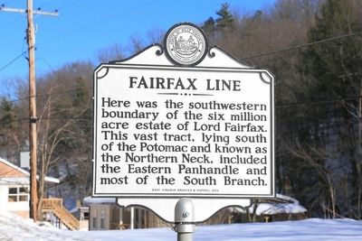
Fairfax Line
Erected 2012 by West Virginia Archives and History.
Topics and series. This historical marker is listed in these topic lists: Colonial Era • Settlements & Settlers. In addition, it is included in the West Virginia Archives and History series list. A significant historical year for this entry is 1737.
Location. 38° 58.766′ N, 79° 7.742′ W. Marker is near Petersburg, West Virginia, in Grant County. Marker is on U.S. 220 just south of the city line, on the right when traveling south. Touch for map. Marker is in this post office area: Petersburg WV 26847, United States of America. Touch for directions.
Other nearby markers. At least 8 other markers are within 2 miles of this marker, measured as the crow flies. War in Grant County (approx. half a mile away); The Tannery in Petersburg, WV (approx. one mile away); Fort Mulligan (approx. one mile away); Maple Hill Cemetery (approx. 1.4 miles away); A Strategic Location (approx. 1˝ miles away); Civil War Cannons (approx. 1.6 miles away); Winter Quarters Huts (approx. 1.6 miles away); Defending the Fort (approx. 1.6 miles away). Touch for a list and map of all markers in Petersburg.
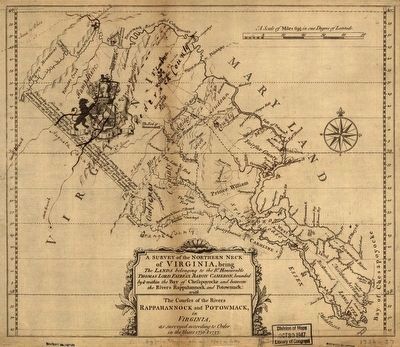
Regarding Fairfax Line. The southern boundary of the “Northern Neck Proprietary” is the Rappahannock River, the northern (and, because of its course, also its northwestern) boundary is the Potomac River, and a straight line drawn between the sources of the Rappahannock and the Potomac rivers its southwestern edge. This straight line is “the Fairfax Line.” The rivers’ sources were not known when King Charles II gave the lands to seven Englishmen. By 1710, Thomas, the sixth Lord Fairfax of Cameron, owned it all. And after a survey in 1747 that drew the Fairfax Line, its size could finally be calculated: this gift from King Charles II was in excess of 8000 square miles (almost the size of New Jersey). Thomas Fairfax, now a Virginia resident, had no children and his ownership of the Northern Neck died with him in 1781. Unsold land within the Northern Neck Proprietary reverted to the Commonwealth of Virginia.
Related markers. Click here for a list of markers that are related to this marker. These markers are listed in no particular order.
Also see . . . The Fairfax Grant. “Lord Fairfax chose a playing field where he had the advantage over the [Virginia] General Assembly by filing the Fairfax v. Virginia suit in London. He recognized that the General Court in Williamsburg, composed of the governor and his appointed Council, would not rule in his favor. The General Assembly, dominated by burgesses elected from counties outside the Northern Neck, was also unlikely to support his claims. ... Lord Fairfax complained to officials in London that every grant authorized by Governor Gooch was illegal.” (Submitted on April 20, 2016.)

Library of Congress, approx 30 x 35 cm.
3. A Survey of the Northern Neck of Virginia
being The Lands belonging to the Right Honorable Thomas Lord Fairfax Baron Cameron, bounded by & within the Bay of Chesapoyocke and between the Rivers Rappahannock and Potowmack: with The courses of the Rivers Rappahannock and Potowmack, in Virginia, as surveyed according to Order in the Years 1836 & 1737. —Click to enlarge.—
Credits. This page was last revised on August 31, 2020. It was originally submitted on April 20, 2016, by J. J. Prats of Powell, Ohio. This page has been viewed 495 times since then and 23 times this year. Last updated on August 30, 2020, by Bradley Owen of Morgantown, West Virginia. Photos: 1, 2. submitted on April 20, 2016, by J. J. Prats of Powell, Ohio. 3. submitted on April 16, 2016, by J. J. Prats of Powell, Ohio. • Devry Becker Jones was the editor who published this page.

