Ione in Amador County, California — The American West (Pacific Coastal)
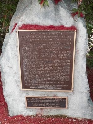
Quincy - Ione's Sister City
Don Andreas Pico purchased the grant from Teodosio Yorba in 1844 with 500 head of longhorn cattle.
Before its destruction, Quincy was quite large. According to the "Quincy Prospector," it rivaled Sacramento in its best days (copies on file in the state archives).
Quincy was built by the settlers coming to California during and before the "Gold Rush" of 1849. The people of Quincy were shocked and astonished when Pico and his vaqueros rode in from Mission San Jose to inform them to vacate, as they were trespassing. Pico was entirely within his rights.
Years of bloodshed followed. This loosely organized war of murder and ambush diminished with the arrival of a battalion of infantry, a battery of field artillery and a troop of cavalry from the Presidio of San Francisco. They garrisoned the area well after 1865.
This came too late, however, for Pico's wife, murdered during this period. Her grave was located 6 miles south of Quincy, near the Miwok town of Uoo-Poo-Soo-Ne. Finally, the settlers were given the choice of Ione or Quincy. With Ione the winner, Quincy was evacuated, burned and dynamited to the ground in two weeks.
After all this time and destruction, aerial photographs still show the four lane main street with parking, and its many large side streets revealed by the short grass cover of the streets against the longer grasses inside the old foundations.
Erected 1987 by Ione Parlor #33 and Grand Parlor, Native Sons of the Golden West, Everett White Jr., Grand President.
Topics and series. This historical marker is listed in these topic lists: Hispanic Americans • Settlements & Settlers. In addition, it is included in the Native Sons/Daughters of the Golden West series list.
Location. 38° 22.068′ N, 120° 57.323′ W. Marker is in Ione, California, in Amador County. Marker can be reached from Michigan Bar Road (California Route 104) 1˝ miles East Plymouth Highway (California Route 124). Touch for map. Marker is at or near this postal address: 4001 Hwy 104, Ione CA 95640, United States of America. Touch for directions.
Other nearby markers. At least 8 other markers are within 2 miles of this marker, measured as the crow flies. Preston Castle (approx. 0.3 miles away); Scully Ranch (approx. one mile away); Ione Brewery (approx. 1˝ miles away); The Heirloom (approx. 1˝ miles away); Ione Pavilion (approx. 1˝ miles away); In Honor of Ione's Bravest
(approx. 1˝ miles away); Steam Flour Mill (approx. 1˝ miles away); Iron Ivan (approx. 1.6 miles away). Touch for a list and map of all markers in Ione.
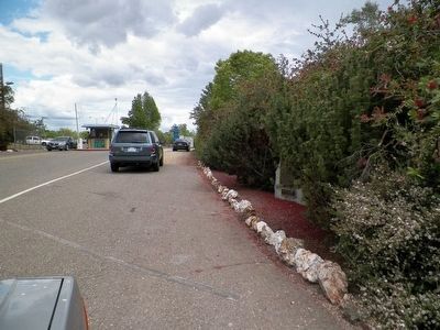
More about this marker. This marker is inside the west entrance to Mule Creek State Prison (before the guard shack).
Credits. This page was last revised on June 16, 2016. It was originally submitted on May 21, 2016, by James King of San Miguel, California. This page has been viewed 463 times since then and 18 times this year. Photos: 1, 2, 3. submitted on May 21, 2016, by James King of San Miguel, California. • Syd Whittle was the editor who published this page.


