Near Moab in Grand County, Utah — The American Mountains (Southwest)
Moab Utah UMTRA Project
Background and Current Status
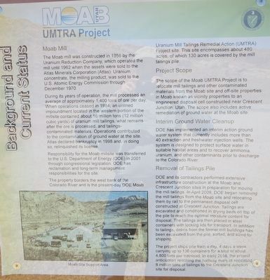
The Moab mill was constructed in 1956 by Uranium Reduction Company, which operated the mill until 1962 when the assets were sold to the Atlas Minerals Corporation (Atlas). Uranium concentrate, the milling product, was sold to the U.S. Atomic Commission through December 1970.
During its years of operation, the mill processed an average of approximately 1,400 tons of ore per day. When operations ceased in 1984, an unlined impoundment located in the western portion of the millsite contained about 16 million tons (12 million cubic yards) of uranium mill tailings, what remains after the ore is processed, and tailings – contaminated materials. Operations contributed to the contamination of ground water at the site. Atlas declared bankruptcy in 1998 and, in doing so, relinquished its license.
Responsibility for the Moab millsite was transferred to the U.S. Department of Energy (DOE) in 2001 through congressional legislation. DOE has reclamation and long-term management responsibilities for the site.
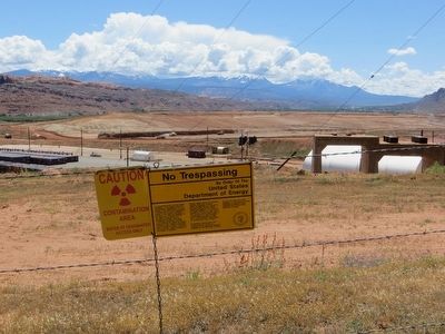
The property borders the west bank of the Colorado River and is the present-day DOE Moab Uranium Mill Tailings Remedial Action (UMTRA) Project site. The site encompasses about 480 acres, of which 130 acres is covered by the mill tailings pile.
Project Scope
The scope of the Moab UMTRA Project is to relocate mill tailings and other contaminated materials from the Moab site and off-site properties in Moab known as vicinity properties to an engineered disposal cell constructed near Crescent Junction, Utah. The scope also included active remediation of ground water at the Moab site.
Interim Ground Water Cleanup
DOE has implemented at interim action ground water system that currently includes more than 40 extraction and freshwater injection wells. The system is designed to protect surface water in suitable habitat areas and to recover ammonia, uranium, and other contaminants prior to discharge to the Colorado River.
Removal of Tailings Pile
DOE and its contractors performed extensive infrastructure construction at the Moab and Crescent Junction sites in preparation for moving the mill tailings. In April 2009, DOE began removing the mill tailings from the Moab site and relocating them by rail to the permanent disposal cell constructed at Crescent Junction. Tailings are excavated and conditioned in drying beds on top of the pile to reach the optimal moisture content for disposal. The tailings are then placed in steel containers with locking lids for transport. In addition to tailings, debris from the former mill buildings has been excavated from the pile , sorted and sized for shipping.
The project ships one train a day, 4 days a week carrying up to 136 containers for a total of about 4,800 tons per trainload. In early 2016, the project anticipates reaching the halfway mark of relocating 8 million tons of tailings to the Crescent Junction site for disposal.
Topics. This historical marker is listed in these topic lists: Environment • Industry & Commerce. A significant historical month for this entry is April 2009.
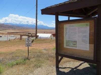
Location. 38° 36.217′ N, 109° 36.195′ W. Marker is near Moab, Utah, in Grand County. Marker is on Utah Route 279, 0.2 miles west of U.S. 191, on the left when traveling west. Touch for map. Marker is in this post office area: Moab UT 84532, United States of America. Touch for directions.
Other nearby markers. At least 8 other markers are within 4 miles of this marker, measured as the crow flies. Utah Serviceberry (approx. 1.3 miles away); Rubber Rabbitbrush (approx. 1.3 miles away); Harriman's Yucca (approx. 1.3 miles away); Grand Old Ranch House (approx. 2.3 miles away); Scott M. Matheson (approx. 2.7 miles away); Star Hall History (approx. 3.7 miles away); Star Hall (approx. 3.7 miles away); Early L.D.S. Church (approx. 3.7 miles away). Touch for a list and map of all markers in Moab.
Credits. This page was last revised on June 16, 2016. It was originally submitted on June 8, 2016, by Bill Kirchner of Tucson, Arizona. This page has been viewed 568 times since then and 21 times this year. Photos: 1, 2, 3. submitted on June 8, 2016, by Bill Kirchner of Tucson, Arizona.


