Union City in Branch County, Michigan — The American Midwest (Great Lakes)
J.P. Palmer Launch and & Railroad Trestle
Union City Heritage Water Trail

Photographed By Val Rossman, July 3, 2016
1. J.P. Palmer Launch and & Railroad Trestle Marker
Union City Heritage Water Trail website entry #2
Click for more information.
Click for more information.
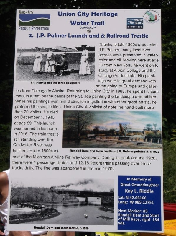
Thanks to late 1800s area artist J.P. Palmer, many local river scenes were preserved in watercolor and oil. Moving here at age 10 from New York, he went on to study at Albion College and the Chicago Art Institute. His paintings were in great demand with some going to Europe and galleries from Chicago to Alaska. Returning to Union City in 1888, he spent his summers in a tent on the banks of the St. Joe painting the landscape around him. While his paintings won him distinction in galleries with other great artists, he preferred the simple life in Union City. A violinist of note, he hand-built more than 20 violins. He died on December 4, 1945 at age 89. This launch was named in his honor in 2016. The train trestle still standing over the Coldwater River was built in the late 1800s as part of the Michigan Air-line Railway Company. During its peak around 1920, there were 4 passenger trains and 12-16 freight trains passing over these tracks daily. The line was abandoned in the mid 1970s.
Erected 2016 by Union City Heritage Water Trail. (Marker Number 2.)
Topics and series. This historical marker is listed in these topic lists: Arts, Letters, Music • Railroads & Streetcars • Waterways & Vessels. In addition, it is included in the Michigan - Union City Heritage Water Trail series list. A significant historical date for this entry is December 4, 1945.
Location. 42° 3.7′ N, 85° 7.651′ W. Marker is in Union City, Michigan, in Branch County. Marker is on Coldwater St.. While most of these Union City Heritage Water Trail are on private property and meant be viewed from the Coldwater an St. Joe Rivers this one can be seen at the launch on the Coldwater River on Village Property. Turn into the area marked for the kayak launch in the southeast corner of the village along Coldwater St at the west side of the bridge on Coldwater St. (known by various mapping programs also as Union City Rd. and Coldwater Rd.--occasionally GPS mapping programs put this address far out of the village of Union City and near Hodunk, MI. in this case the program is error) and is on Union City Village property. Continue along the drive back to the launch area. Touch for map. Marker is at or near this postal address: 206 Coldwater St, Union City, MI, Union City MI 49094, United States of America. Touch for directions.
Other nearby markers. At least 8 other markers are within walking distance of this marker. Union City Heritage Water Trail (Trailhead Sign) (about 300 feet away, measured in a direct line); Randall Dam & Start of Millrace (about 400 feet away); Coldwater River & Bridge (approx. ¼ mile away); Union City Creamery (approx. ¼ mile away); Union City Iron Furnace (approx. 0.3 miles away); Narrow Gauge Railway to the Cement Factory (approx. 0.3 miles away); "Union" of the Rivers (approx. 0.4 miles away); The St. Joe Tavern & The Bucket (approx. 0.4 miles away). Touch for a list and map of all markers in Union City.
More about this marker. There are 28 of these markers comprising the Union City Heritage Water Trail on the Coldwater River and the St. Joseph River launched in 2016 for the village's Sesquicentennial. These markers can be viewed by paddling the 5 mile stretch of river from the JP Palmer Launch in the Village of Union City to the Riley Dam on the SW Corner of Union Lake. Most of these markers CANNOT by accessed by foot as they are on private property along the river. Please do not trespass. More details can be found at www.uchwt.com
Credits. This page was last revised on April 9, 2022. It was originally submitted on July 8, 2016, by Val Rossman of Union City, Michigan. This page has been viewed 305 times since then and 12 times this year. Photo 1. submitted on July 8, 2016, by Val Rossman of Union City, Michigan. • Bill Pfingsten was the editor who published this page.
Editor’s want-list for this marker. View of the marker in context • Can you help?