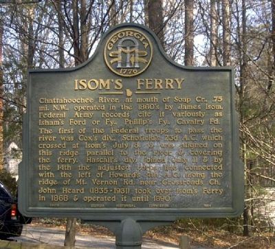
Sandy Springs in Atlanta in Fulton County, Georgia — The American South (South Atlantic)
Isom's Ferry
Erected 1954 by Georgia Historical Commission. (Marker Number 060-8.)
Topics and series. This historical marker is listed in this topic list: War, US Civil. In addition, it is included in the Georgia Historical Society series list. A significant historical year for this entry is 1868.
Location. 33° 55.263′ N, 84° 25.328′ W. Marker is in Atlanta, Georgia, in Fulton County. It is in Sandy Springs. Marker is on Heards Drive, ¼ mile west of Heards Ferry Road, on the left when traveling west. Marker is located in the old Heard Family Cemetery, at the end of Heards Drive. Touch for map. Marker is at or near this postal address: 6065 Heards Drive, Atlanta GA 30328, United States of America. Touch for directions.
Other nearby markers. At least 8 other markers are within 2 miles of this marker, measured as the crow flies. Confederate Battery Position (approx. 0.4 miles away); 4th & 23d A.C. Advance (approx. 1.1 miles away); To Sandy Springs and Old Cross Keys (approx. 1½ miles away); Howard's 4th A.C. Line (approx. 1.6 miles away); 23d A.C. to Decatur (approx. 1.7 miles away); Soap Creek Paper Mills (approx. 1.7 miles away); The 23d Corps at Soap Creek (approx. 1.7 miles away); The 23D Corps at Soap Creek (approx. 1.7 miles away).
Credits. This page was last revised on February 8, 2023. It was originally submitted on July 26, 2008, by David Seibert of Sandy Springs, Georgia. This page has been viewed 1,647 times since then and 32 times this year. Photos: 1, 2. submitted on July 26, 2008, by David Seibert of Sandy Springs, Georgia. • Craig Swain was the editor who published this page.

