Tecpán Guatemala, Chimaltenango, Guatemala — Central America
Mesoamerica and the Mayan Civilization
Mayan Civilization in the Highlands from the Preclassic through the Classic Periods
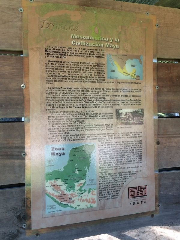
Mesoamérica y la Civilización Maya
La Civilización Maya a la cual pertenece los Kaqchikeles se desarrolló en el sector sur de Mesoamérica, región que se extiende desde el actual noroeste de México hasta Honduras y parte de Nicaragua y Costa Rica al Sur.
Mesoamérica agrupa diferentes grupos étnicos y lingüísticos que desarrollaron en el tiempo sociedades complejas y diversas, compartiendo sin embargo rasgos culturales como: técnicas agrícolas, una dieta a base de maíz, frijol y calabaza, mercados y redes de comercio, así como un sistemas calendárico y tradiciones artísticas comunes.
La Civilización Maya agrupa el conjunto de las sociedades desarrolladas por los ancestros de los 22 grupos lingüísticos mayas conocidos en la actualidad, todos descendientes de un tronco lingüístico-cultural mayense común.
La llamadas Zona Maya ocupa una región que abarca de Norte a Sur, parcialmente o totalmente los estados mexicanos actuales de Tabasco, Campeche, Chiapas, Yucatán y Quintana Roo, Belice, Guatemala, El Salvador así como la parte norte de Honduras.
Es un territorio tan extenso, con influencias culturales, paisajes y climas tan diversos, las sociedades no se desarrollaron de la misma manera ni al mismo tiempo.
Por ello, se divide generalmente la Zona Maya en dos grandes sectores geográficos: Las Tierras Bajas, cuna de la Civilización Maya llamada Clásica (Tikal) y las Tierras Altas en las cuales los conquistadores españoles encontraron a su llegada, las naciones K’iché, Kaqchikel y Tzutuhil entre otras.
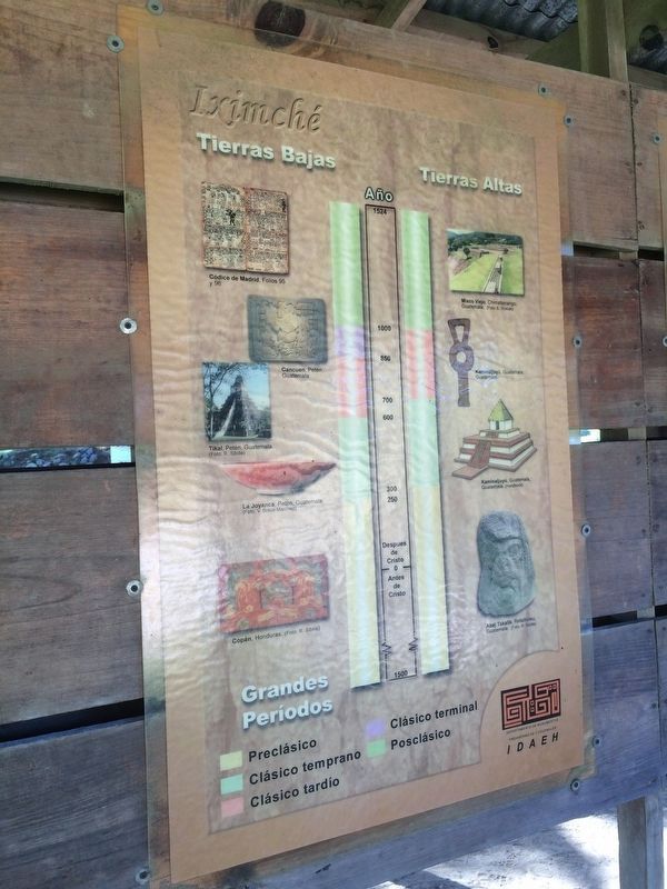
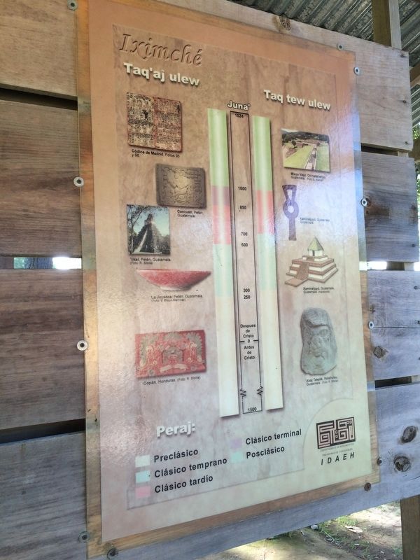
La Cronología de las Tierras Bajas se divide en tres grandes periodos:
- El periodo Preclásico (de 2000 a.C. a 250 d.C.)
Durante este periodo se inicia la construcción de los grandes centros urbanos como El Mirador, Tikal, Uaxactún y Nakbé en las Tierras Bajas del Petén asociado con el desarrollo de formas artísticas influenciadas por la Cultura Olmeca.
- El período Clásico (de 250 a 1000 d.C.)
Representa el momento de apogeo de la Civilización Maya de las Tierras Bajas con sus grandes ciudades-estados como Tikal, El Naranjo, Copán, Piedras Negras, Palenque, Quiriguá, Toniná, Cancuen entre otras.
Las dinastías gobernantes erigen sus primeras estelas, sembrando los cimientos de sus futuros reinados, bajo una influencia teotihuacana proveniente del Altiplano mexicano.
Los siglos VII, VIII y parcialmente IX, conocen el apogeo de los grandes centros peteneros, es el Clásico Tardío.
Sin embargo, después de un período de Guerra entre los
diferentes estados, desaparecen las élites y los reyes, llevando los grandes sitios a un abandono parcial o total. Más al norte, en la Península de Yucatán, es el auge de las ciudades de Calakmul y otras metrópolis de las regiones Chenes y Puuc. En el llamado Clásico Terminal de las Tierras Bajas (entre 850 y 1000 d.C.), mientras que los centros peteneros son poco a poco abandonados, los sitios yucatecos de Uxmal, Chichén Itzá y Cobá desarrollan una actividad constructiva importante.
- El Posclásico (de 1000 d.C. a la llegada de los Españoles).
Es la época del apogeo de las ciudades de Mayapán y Chichén Itzá, con marcadas influencias culturales toltecas. Alrededor de 1250, los centros cívico-ceremoniales yucatecos son abandonados y los Españoles encuentran a su llegada a Yucatán, una región políticamente fragmentada cuyo control está detenido por diversas familias.
Pie de dibujo:
Tikal, Centro Ceremonial
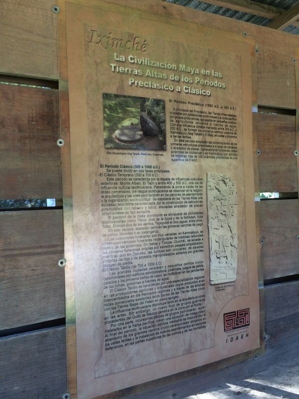
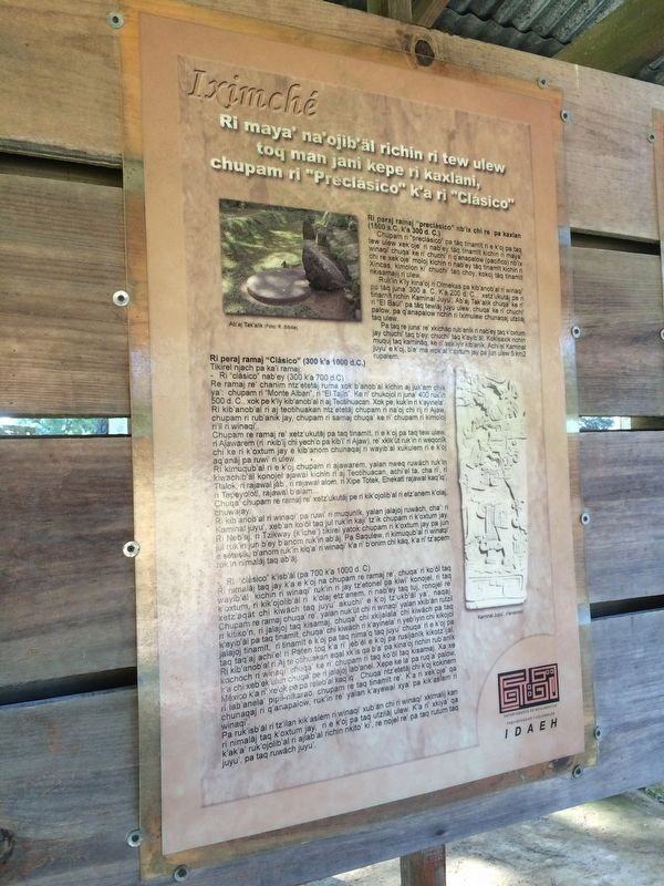
La Civilización Maya en las Tierras Altas de los Períodos Preclásico a Clásico
El Periodo Preclásico (1500 a.C. a 300 d.C.)
A principios del Preclásico, las Tierras Altas estaban ocupadas por poblaciones proto-mayas y la costa pacífica por grupos proto-xincas, agrupados en pequeños pueblos de agricultores cercanos a fuentes de agua. Con una influencia olmeca marcada, entre 300 a.C. y 200 d.C., se forman los primeros centros urbanos
de Kaminaljuyú, Abaj Takalik y El Baúl, en valles y próximos a tierras fértiles.
En este período empiezan las construcciones de las primeras estructuras piramidales a lo largo de calzadas o alrededor de plazas. Generalmente funerarias, estas pirámides se multiplican y en Kaminaljuyú por ejemplo se registran más de 100 pirámides preclásicas en una superficie de 5 km2.
El Período Clásico (300 a 1000 d.C.)
Se puede dividir en dos fases principales:
- El Clásico Temprano (300 a 700 d.C.)
Este período se caracteriza por la llegada de influencias culturales exteriores: Monte Alban, El Tajín y entre 400 y 500 d.C. una ola de influencia cultural teotihuacana. Penetrando la zona a través de las redes comerciales, los rasgos teotihuacanos se observan en la religión, la arquitectura y las artes pero también en los patrones de asentamiento y la organización socio-política. Se establece en las Tierras Altas una sociedad teocrática caracterizada por la construcción de estructuras piramidales con tablero y talud, elevadas alrededor de plazas ceremoniales de tipo acrópolis.
El panteón de la clase dominante se enriquece de divinidades teotihuacanas como Tlaloc, dios de la lluvia y de la fertilidad, Xipe Totec, Ehecatl, dios de los vientos, Tepeyolotl el dios jaguar, entre otros.
En este período, aparecen también las primeras canchas de juego de pelota
(abiertas o en palangana).
Las costumbres funerarias son muy variadas: en Kaminaljuyú, se construyen cámaras funerarias rectangulares de medidas reducidas dentro de las pirámides. En Nebaj y Tzicuay (Quiché), se accede a las cámaras funerarias amplias por estrechos pasajes empedrados, mientras que en Zaculeu, las tumbas son circulares, de paredes pintadas de rojo y de accesos mamposteados sellados por grandes bloques de piedra
- El Clásico Tardío (de 700 a 1000 d.C.)
Las grandes ciudades persisten y pequeños centros cívico-ceremoniales con edificios administrativos, pirámides, juegos de pelota, palacios y los primeros baños de vapor, se multiplican en las pendientes de las lomas, próximas a fuentes de agua.
El Clásico Tardío se caracteriza por una especialización regional en las producciones agrícolas y artesanales cuyos productos eran intercambiados en los mercados regiones y a través de las amplias redes comerciales existentes tanto dentro de las Tierras Altas como con las Tierras Bajas de Petén en pleno apogeo.
La influencia teotihuacana disminuye tanto en la arquitectura como en las artes. Sin embargo, un nuevo fluyo de grupos guerreros procedentes del Golfo de México penetra en la zona por el Norte.
Por otra parte, incursiones bélicas de grupos pipil-nicarao, recién instalados en la franja pacífica, crean una situación de inseguridad. Al final del
período, la situación política inestable se traduce por el abandono de los grandes centros cívico-ceremoniales ubicados en los valles fértiles y la instalación de nuevos asentamientos en sectores defensivos, en las partes superiores de las colinas y de las montañas.
Pie de dibujo:
Sitio Arqueológico Abaj Takalik, Retalhuleu, Guatemala.
Estela de Kaminaljuyú, Guatemala.
Mesoamerica and the Mayan Civilization
Mayan Civilization, of which the Kakchiquel are a part, developed in the southern part of Mesoamerica, a region extending from the current area of northwestern Mexico down to Honduras, part of Nicaragua and Costa Rica to the south.
Mesoamerica included different ethnic and linguistic groups that developed over time complex and diverse societies, but sharing cultural traits such as agricultural techniques, a diet based on corn, beans and squash, markets and trade networks, as well as a shared calendar system and common artistic traditions.
The Mayan Civilization brings together all societies developed by the ancestors of the 22 Maya linguistic groups known at present, all descendants of a common linguistic and cultural Mayan ancestral line.
The Maya Area occupies a region spanning from north to south, partially or totally the current Mexican states of Tabasco, Campeche,
Chiapas, Quintana Roo and Yucatan, Belize, Guatemala, El Salvador and the northern part of Honduras.
It is such a vast territory, with different cultural influences and diverse landscapes and climates, so its societies did not develop in the same way or at the same time.
The Maya Area is usually divided into two main geographical areas: the Lowlands, which include the cradle of Classic Mayan civilization with its best example at Tikal, and the Highlands, where the Spanish conquistadors found upon their arrival, the nations of the K’iché, Kaqchikel and Tzutuhil, among others.
The Chronology of the Lowlands is divided into three periods:
- The Preclassic (2000 BC to 250 AD)
During this period the construction of large urban centers, such as El Mirador, Tikal, Uaxactún and Nakbé start in the lowlands of Petén and are associated with the development of art forms influenced by the Olmeca Culture.
- The Classic period (250-1000 AD)
It represents the high point of the Mayan Civilization of the Lowlands with its large city-states such as Tikal, El Naranjo, Copán, Piedras Negras, Palenque, Quiriguá, Tonina, Cancuén, among others.
The ruling dynasties erected their first stelae, sowing the foundations of future kingdoms, under influence from the Highland city-state of Teotihuacan, in what is now Mexico.
The VII, VIII and IX centuries are normally
known as the Late Classic period, and include the development of the great city-states of the Petén.
However, after a period of war between the states, elites and kings disappear, bringing major sites to a partial or total abandonment. Further north, in the Yucatán peninsula, the cities of Calakmul and other metropolises of the Chenes and Puuc regions grow and develop. In the so-called Lowland Terminal Classic Period (between 850 and 1000 A.D.), while the city-states of the Petén are gradually abandoned, the Yucatecan sites of Uxmal, Chichen Itza and Coba develop an important construction activity.
- The Post Classic Period (1000 A.D. until the arrival of the Spaniards)
The is the highpoint of the cities of Mayapan and Chichen Itza, both with marked Toltec cultural influences. Around 1250, the civic-ceremonial centers in the Yucatán are abandoned and the Spaniards found upon their arrival in Yucatán, a politically fragmented region whose control is stopped by various families
Caption:
Tikal, Ceremonial Center
Mayan Civilization in the Highlands from the Preclassic through the Classic Periods
The Preclassic Period (1500 BC to 300 AD)
During the early Preclassic Period, the Highlands were occupied by proto-Mayan populations and the Pacific coast by proto-Xinca groups, living in small villages near water sources and working as farmers. With a strong Olmec influence, between 300 B.C. and 200 A.D., the first urban centers of Kaminaljuyu, Abaj Takalik and El Baul, in valleys and near fertile lands, are formed. In this period start the construction of the first pyramidal structures along roads or nearby locations. These pyramids multiply as they are created as funeral sites. At Kaminaljuyú, for example, more than 100 pre-Classical pyramids are recorded in an area of just 5 km2.
The Classic Period (300-1000 AD)
can be divided into two main phases:
- The Early Classic period (300-700 AD)
This period is characterized by the arrival of foreign cultural influences: Monte Alban, Tajin and then, between 400 and 500 AD, a wave of cultural influence from Teotihuacán. Penetrating the area through commercial networks, Teotihuacán features can be observed in the religion, architecture and the arts, but also in patterns of settlement and socio-political organization. It established a theocratic society characterized by the construction of pyramidal structures using the slope and panel style, with high ceremonial plazas around an acropolis in the Highlands.
The pantheon of the ruling class is enriched by Teotihuacan divinities, such as Tlaloc, the god of rain and fertility, Xipe Totec and Ehecatl, god of the winds, Tepeyolotl, the jaguar god, among others.
In this period also appear the first ballgame courts.
The funeral customs are varied: in Kaminaljuyú, rectangular burial chambers of small dimensions are built inside the pyramids. The access to the the spacious burial chambers in Nebaj and Tzicuay (Quiché) are by narrow, cobbled passages, while in Zaculeu, the tombs are circular, with walls painted red and access routes lined with stone and sealed by large stone blocks.
- The Late Classic Period (700 to 1000 AD)
During this Period the large cities continue and small civic-ceremonial centers are created with administrative buildings, pyramids, ball courts, palaces and the first steam baths, developing on the slopes of hills, close to water sources.
The Late Classic is characterized by regional specialization in agricultural and handicraft production, with those products being exchanged in lively markets in many regions through the vibrant existing commercial networks both within the Highlands and in the Lowlands of Petén.
Teotihuacán influence decreases both in architecture and the arts. However, a new group of warriors flowed from the Gulf of Mexico and enters the area from the north.
These military incursions by the Nicarao-Pipil, newly installed groups on the Pacific Coast, create a situation of insecurity. At the end of the period, the unstable political situation resulting from the abandonment of the great civic-ceremonial centers located in the fertile valleys leads to the installation of new settlements in defensive sectors on the tops of the hills and mountains.
Caption:
Archaeological Site at Takalik Abaj, Retalhuleu, Guatemala.
Stela at Kaminaljuyú, Guatemala.
Topics. This historical marker is listed in these topic lists: Agriculture • Anthropology & Archaeology. A significant historical year for this entry is 2000.
Location. 14° 44.154′ N, 90° 59.796′ W. Marker is in Tecpán Guatemala, Chimaltenango. The marker is directly to the left some meters after the entrance to the Archaeological Park of Iximche. The park is south of the city of Tecpán Guatemala on a road known locally as the "Road to Iximche". Touch for map. Marker is in this post office area: Tecpán Guatemala, Chimaltenango 04006, Guatemala. Touch for directions.
Other nearby markers. At least 8 other markers are within walking distance of this marker. Mayan Civilization in the Post Classic Period (a few steps from this marker); Southwest Area (within shouting distance of this marker); Plaza A of Iximche (within shouting distance of this marker); Entrance to the City's Center (within shouting distance of this marker); Stela Commemorating the End of the Oxlajpiq/Oxlajb’ak’tun (within shouting distance of this marker); The Sociopolitical Organization of Mayan Social Classes (about 120 meters away, measured in a direct line); Sotz'il Palace (about 150 meters away); Temple 5 at Iximche (approx. 0.2 kilometers away). Touch for a list and map of all markers in Tecpán Guatemala.
Credits. This page was last revised on March 2, 2018. It was originally submitted on July 24, 2016, by J. Makali Bruton of Accra, Ghana. This page has been viewed 445 times since then and 25 times this year. Photos: 1. submitted on July 24, 2016, by J. Makali Bruton of Accra, Ghana. 2, 3, 4, 5, 6, 7. submitted on July 25, 2016, by J. Makali Bruton of Accra, Ghana.
