DeValls Bluff in Prairie County, Arkansas — The American South (West South Central)
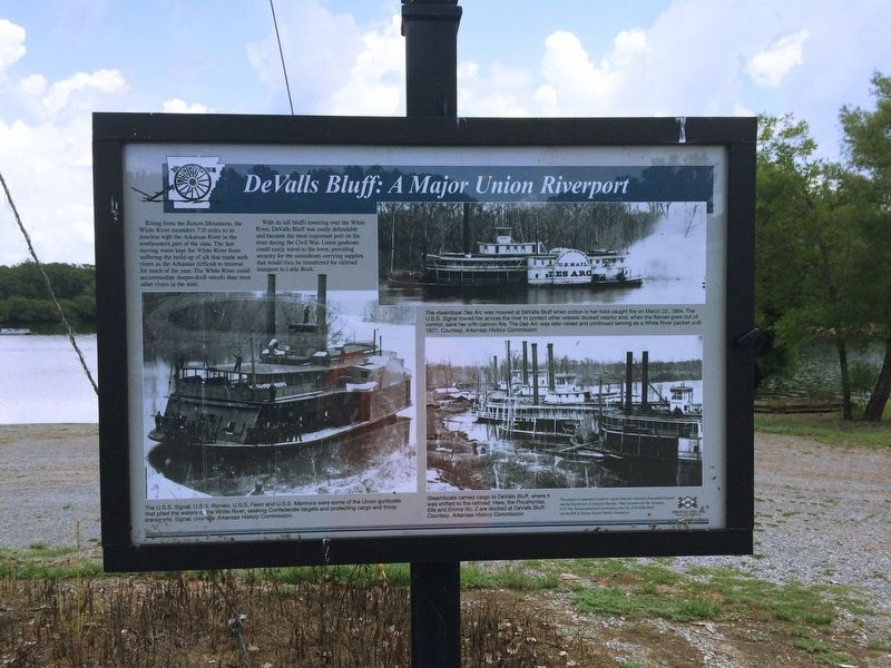
DeValls Bluff: A Major Union Riverport
Rising from the Boston Mountains, the White River meanders 720 miles to its junction with the Arkansas River in the southeastern part of the state. The fast-moving water kept the White River from suffering the build-up of silt that made such rivers as the Arkansas difficult to traverse for much of the year. The White River could accommodate deeper-draft vessels than most other rivers in the state.
With its tall bluffs towering over the White River, DeValls Bluff was easily defendable and became the most important port on the river during the Civil War. Union gunboats could easily travel to the town, providing security for the steamboats carrying supplies that would then be transferred for railroad transport to Little Rock.
(Upper Image Caption)
The steamboat Des Arc was moored at DeValls Bluff when cotton in her hold caught fire on March 22, 1864. The U.S.S. Signal towed her across the river to protect other vessels docked nearby and, when the flames grew out of control, sank her with cannon fire. The Des Arc was later raised and continued serving as a White River packet until 1871. Courtesy, Arkansas History Commission.
(Lower Left Image Caption)
The U.S.S. Signal, U.S.S. Romeo, U.S.S. Fawn and U.S.S. Marmora were some of the Union gunboats that plied the waters of the White River, seeking Confederate targets and protecting cargo and troop transports. Signal, courtesy Arkansas History Commission.
(Lower Right Image Caption)
Steamboats carried cargo to DeValls Bluff, where it was shifted to the railroad. Here, the Pocahontas, Ella and Emma No. 2 are decked at DeValls Bluff. Courtesy, Arkansas History Commission.
Topics. This historical marker is listed in these topic lists: Railroads & Streetcars • War, US Civil • Waterways & Vessels. A significant historical month for this entry is August 1863.
Location. 34° 47.233′ N, 91° 27.373′ W. Marker is in DeValls Bluff, Arkansas, in Prairie County. Marker is on Railroad Street east of Main Street (Arkansas Highway 33), on the right when traveling north. Touch for map. Marker is in this post office area: De Valls Bluff AR 72041, United States of America. Touch for directions.
Other nearby markers. At least 8 other markers are within walking distance of this marker. The Memphis and Little Rock Railroad (about 700 feet away, measured in a direct line); a different marker also named Memphis and Little Rock Railroad (about 700 feet away); Why DeValls Bluff (approx. ¼ mile away); DeValls Bluff Under Fire (approx. ¼ mile away); DeValls Bluff in the Civil War (approx. ¼ mile away); War on the White River
(approx. ¼ mile away); Common Ground for Many Soldiers (approx. ¼ mile away); DeValls Bluff: A Key Union Base (approx. ¼ mile away). Touch for a list and map of all markers in DeValls Bluff.
More about this marker. Marker is one of seven interpretive signs on the Civil War in DeValls Bluff.
Also see . . .
1. DeValls Bluff (Prairie County). From The Arkansas Encyclopedia of History & Culture. Includes information on De Valls Bluff’s role in the Civil War. (Submitted on August 10, 2016.)
2. DeValls Bluff. Arkansas Department of Parks, Heritage, and Tourism website entry (Submitted on March 4, 2024, by Larry Gertner of New York, New York.)
Additional commentary.
1. Marker Sponsors
The following is written at the lower right corner of the marker: “This project is supported in part by a grant from the Arkansas Humanities Council and the Department of Arkansas Heritage. Other sponsors are the Arkansas Sesquicentennial Commission, the City of DeValls Bluff and the Bill & Sharon Arnold Family Foundation.”
— Submitted
August 10, 2016.
Credits. This page was last revised on March 4, 2024. It was originally submitted on August 10, 2016, by Duane Hall of Abilene, Texas. This page has been viewed 457 times since then and 23 times this year. Photos: 1, 2. submitted on August 10, 2016, by Duane Hall of Abilene, Texas.

