Near Dahlonega in Lumpkin County, Georgia — The American South (South Atlantic)
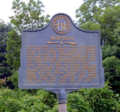
Auraria
From Auraria in 1858 the “Russell boys”, led by Green Russell, went west and established another Auraria near the mouth of Cherry Creek that later became Denver, Colo. Green Russell uncovered a fabulous lode called Russell Gulch near which was built Central City, Colo., “richest square mile on earth.”
Erected 1954 by Georgia Historical Commission. (Marker Number 093-5.)
Topics and series. This historical marker is listed in these topic lists: Industry & Commerce • Native Americans • Settlements & Settlers. In addition, it is included in the Georgia Historical Society series list. A significant historical year for this entry is 1832.
Location. 34° 28.467′ N, 84° 1.427′ W. Marker is near Dahlonega, Georgia, in Lumpkin County. Marker is at the intersection of Auraria Road (Georgia Route 9) and Castleberry Bridge Road, on the left when traveling north on Auraria Road. Touch for map. Marker is in this post office area: Dawsonville GA 30534, United States of America. Touch for directions.
Other nearby markers. At least 8 other markers are within 5 miles of this marker, measured as the crow flies. The Station (approx. one mile away); Calhoun Gold Mine (approx. 3 miles away); Mt. Hope Cemetery (approx. 4.2 miles away); Dahlonega Mint (approx. 4.4 miles away); Price Memorial Building (approx. 4.4 miles away); U.A. Lawson Steeple (approx. 4.4 miles away); William Pierce Price (approx. 4.4 miles away); a different marker also named Price Memorial Building (approx. 4.4 miles away). Touch for a list and map of all markers in Dahlonega.
Additional keywords. Gold
Credits. This page was last revised on January 31, 2020. It was originally submitted on August 5, 2008, by David Seibert of Sandy Springs, Georgia. This page has been viewed 1,918 times since then and 33 times this year. Photos: 1, 2. submitted on August 5, 2008, by David Seibert of Sandy Springs, Georgia. • J. J. Prats was the editor who published this page.

