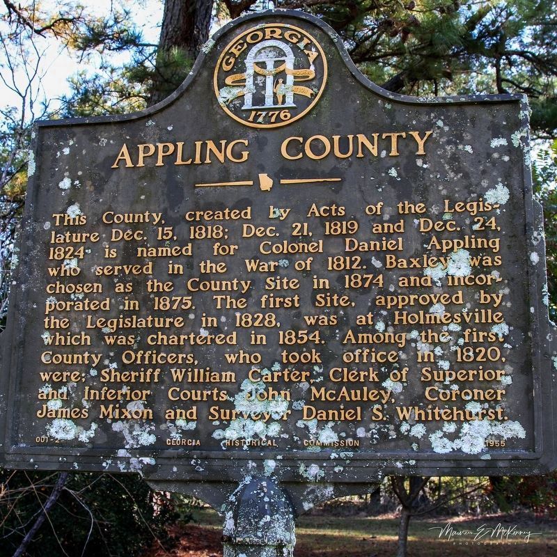
This County, created by Acts of the Legislature Dec. 15, 1818; Dec. 21, 1819 and Dec. 24, 1824 is named for Colonel Daniel Appling who served in the War of 1812. Baxley was chosen as the County Site in 1874 and incorporated in 1875. The first Site, . . . — — Map (db m156561) HM
Baxley's Caroline Pafford Miller (1903-1992) was the first Georgia novelist to be awarded the Pulitzer Prize for Literature. The author was born in Waycross and spent her formative years in the South Georgia wiregrass country. After moving to . . . — — Map (db m10079) HM
You are standing at the historic terminus of Broad St. Through this iron gable - which represents an original wooden covered bridge to Cook & Brother Factory - you can view historic Downtown Athens. — — Map (db m195756) HM
Generation after generation of people worked, shopped, played, prayed, married, and were buried within this river-based community.
Many former slaves settled into small houses on the floodplain of the North Oconee River in areas called . . . — — Map (db m206380) HM
In 1783 the Oconee River basin was the western boundary of the new United States of America. The first U.S. frontiersmen included surveyors, mapmakers, native guides, and naturalists.
To entice farmers to the new territory, the U.S. . . . — — Map (db m206381) HM
Here, about 1873, on Lot No. 1, S.J. Henderson built the first residence in Pearson, then the terminus of the Brunswick and Albany R. R. Successively the home of prominent families in early Pearson history, in 1905 it became the residence of Martin . . . — — Map (db m53174) HM
Salem Church was built in 1889 on the Kinnaird Trail -– an Indian pathway that later became a stagecoach relay station. Martin S. Corbett was born here on 5-12-1840 and married cousin, Leonora Wealtha Pafford on 11-26-1867. Their home was . . . — — Map (db m53290) HM
Milford Baptist Church stood on this site for more than 120 years from about 1880 until February 2002. These rocks served as pillars for that building just as Milford Baptist Church has been the foundation of this community since 1834. The . . . — — Map (db m218688) HM
This County, created by Acts of the Legislature Dec. 12 & 24, 1825, is named for Col. John Baker of Revolutionary fame. The original County Site was at Byron but an Act of Dec. 26, 1831, established a new Site which was named Newton for Sgt. John . . . — — Map (db m26981) HM
In May 1539 Hernando de Soto landed in Florida with over 600 people, 220 horses and mules, and a herd reserved for famine. Fired by his success in
Pizarro's conquest of Peru, De Soto had been granted the rights, by the King of Spain, to explore, . . . — — Map (db m27275) HM
Three hundred yards east of this point stood Ft. Wilkinson, established in 1797 on Georgia's Indian boundary. Garrisoned by soldiers whose families lived outside the stockade, it was an early trading house where Creek Indians were provided . . . — — Map (db m13140) HM
Site of the large Baldwin County plantation of Howell Cobb, one of the 'Great Georgia Triumvirate' of Stephens, Toombs and Cobb, and his wife, the former
Mary Ann Lamar. Born at Cherry Hill in Jefferson County, Georgia Sept. 7, 1815, he graduated . . . — — Map (db m13137) HM
Jarrett Springs formerly known as Commissioners Springs,
flows in an enclosed structure about 40 yards on adjacent land.
In 1803, because of the abundant and clear water supply,
this site was selected by the Georgia Legislature as the . . . — — Map (db m43164) HM
The first settlement in this section was made up of four frame houses, a dozen or more cabins and a fort. It was called Federal town. Many of the soldiers died so a new fort was built several miles up the river and named Fort Fidius. It was located . . . — — Map (db m36323) HM
Where treaty of limits took place between the United States and Creek Nation of Indians June 16, 1802, ratified Jan. 11, 1803
This treaty was signed by James Wilkinson, Benjamin Hawkins, Andrew Pickens, Commissioners on the part of the United . . . — — Map (db m239149) HM
This line, sometimes called “The Four Mile Purchase Line” was the boundary between Georgia and the Cherokee Nation from 1804 to 1818. It was established when Georgia bought a four mile strip from the Indians so as to take in Wofford’s . . . — — Map (db m40642) HM
The boundary between the State of Georgia and the Cherokee Nation established by the Treaty of Augusta, May 31, 1783, ran along here. The line ran “from the top of Currahee mountain to the head, or source, of the most southern branch of the . . . — — Map (db m40659) HM
Built circa 1850. Owned by M. John C. Statham. He provided homes for widows of Civil War Veterans; donated land for right-of-way of railroad; streets for town, and a lot for a Methodist Church -- now the city cemetery. Statham, incorporated Dec. 20, . . . — — Map (db m17348) HM
Between the Oconee & Ocmulgee In the late 1700s, the (Muscogee) Creek village of Snoden, present-day Winder, was located within the unbroken forests of Georgia's wilderness. Numerous waterways crisscrossed the landscape supplying . . . — — Map (db m187100) HM
This remarkably preserved log blockhouse was built in 1793, according to historians. There are several references to Fort Yargo as existing prior to 1800. Its location is given as three miles southwest of “Jug Tavern,” original name for Winder. . . . — — Map (db m22396) HM
At one time, settlers used beehive ovens to bake all kinds of foods. Taking its name from its shape, the beehive oven can be found in all parts of the world even today. They are simple to build from clay and straw so there is little or no cost — . . . — — Map (db m187401) HM
Imagine this log building being occupied by 30 to 50 people while under attack by Indians. That was its purpose when it was built in 1792. Settlers in the area took refuge in the fort during times of threat or attack. When it was not being used for . . . — — Map (db m187377) HM
Small forts sprang up across Georgia's Indian lands during and after the Revolutionary War. The Creek, Cherokee, and other native peoples were drawn into the conflict by the British and fought skirmishes against the settlers who were establishing . . . — — Map (db m187300) HM
Settlers established farms as they arrived in new areas. They cleared forest and brush and built fences to corral their livestock, to mark their boundaries, and to keep out predators. The type of fence they built depended on available materials and . . . — — Map (db m187366) HM
Fort Yargo resembles many log cabins built across the southern highlands, especially those of Appalachia. It is one and one-half stories, with front and back doors opposite to each other for air flow during the warmer months. It has a shake roof . . . — — Map (db m187400) HM
Fort Yargo's smokehouse is a reconstruction and is in use most winters. Smokehouses served to cure meat or fish with smoke and salt. Before the invention of refrigeration, fresh meat would not last very long unless it was "smoked" or frozen. In the . . . — — Map (db m187402) HM
Built under the Watershed Protection and Flood Prevention Act 83rd Congress — 1954 by Barrow County, Georgia Oconee River Soil and Water Conservation District City Government of Winder Department of State Parks of Georgia with assistance . . . — — Map (db m173170) HM
For years inestimable the CREEK INDIAN VILLAGE of SNODON stood here. In 1793 ALONZO DRAPER, HOMER JACKSON and HERMAN SCUPEEN and their families became the first white people to establish homes in SNODON. This same year SNODON became JUG TAVERN. In . . . — — Map (db m17349) HM
Adairsville had its beginning in Oothcaloga Valley, two miles north of the present site. It was named for Cherokee Indian Chief John Adair, the son of a Scottish trader and a Cherokee Princess.
Adairsville moved in 1848 to Adair Station . . . — — Map (db m227027) HM
About 2 miles N. is the plantation home of Augustus Crawford Trimble, pioneer settler, member of the Home Guard, and businessman of Adairsville. A son, serving in the 1st Georgia Cavalry under Gen. Joe Wheeler, engaged the enemy on the plantation. . . . — — Map (db m12419) HM
Allatoona was in pioneer days a travel hub, because ridges from east and south met here where it was fairly easy to cross the Allatoona Mountain range by winding over a low ridge, or pass.
The Sandtown or Tennessee Road from the south, and the . . . — — Map (db m13843) HM
The Tennessee Wagon Road was a heavily traveled route that
passed through the Allatoona Mountain Range. It traversed
north to Chattanooga and south to Sandtown, which was
located on the Chattahoochee River just west of Atlanta. As it
ran south . . . — — Map (db m143025) HM
Four miles east, in the gorge of the Etowah River, are the picturesque ruins of the once flourishing town of Etowah, developed by Mark Cooper around his iron furnace and rolling mill. The furnace was built in 1844, following one built in 1837 on . . . — — Map (db m56315) HM
On this site from 1844-1879 stood the plantation of Maj. John Sharpe Rowland and Frances Lewis Rowland. The plantation comprised some 2,500 acres. Rowland’s Ferry was located just northeast of here at the mouth of Pettit’s Creek. The Rowlands also . . . — — Map (db m68747) HM
County seat Cass County 1832-1861. First decision Supreme Court of Georgia, 1846. Name changed to Manassas 1861. Town burned by Sherman 1864 and never rebuilt. — — Map (db m12359) HM
In this valley was once situated the proud town of Cassville, begun in July 1833, as the seat of justice for Cass County and soon the center of trade and travel in the region recently comprising the Cherokee Nation. Both the county and town where . . . — — Map (db m12371) HM
Ante-bellum plantation and residence of the Rev. Charles Wallace Howard, where he established a private school. May 18, 1864. Hardee's A.C. [CS] moved from Adairsville to Kingston on this road enroute to Cass Station. May 19, the 4th and 14th A.C. . . . — — Map (db m13195) HM
Pine Log Town, located on Pine Log Creek in the flat fields slightly over a half mile east of Oak Hill Church north of GA 140, (in Pine Log, Georgia), extended almost a mile along the creek. The lots were 293, 294, 295,296, 317, 318, 284,and 283, in . . . — — Map (db m13190) HM
Founded at Swan in 1895 by Mr. Philander H. Fitzgerald, lawyer, veteran and publisher of the AMERICAN TRIBUNE of Indianapolis, as a soldiers’ colony in the South. Fitzgerald was settled by Union veterans who, tired of Northern winters, flocked from . . . — — Map (db m40377) HM
In the summer of 1836, a company of militia under Capt. Levi J. Knight of near Ray City was sent to protect the settlers from marauding Indians on their way to join the Seminoles in Florida. When a party of Indians plundered the plantation of . . . — — Map (db m40123) HM
The Old Coffee Road, earliest vehicular and postal route of this section, running southwestward from the Ocmulgee River to the Florida Line, passed through today’s Lax, Nashville, Cecil, Barwick and Thomasville. The thoroughfare was opened by . . . — — Map (db m40124) HM
In May 1539 Hernando de Soto landed in Florida with over 600 people, 220 horses and mules, and a herd reserved for famine. Fired by his success in
Pizarro's conquest of Peru, De Soto had been granted the rights, by the King of Spain, to explore, . . . — — Map (db m27272) HM
Fort Hawkins was established at this site in 1806 on the eastern bank of the Ocmulgee River at the border of the Muskogee Creek Nation. The location was chosen by the fort’s namesake, Benjamin Hawkins, who served as the U.S. Agent for Indian Affairs . . . — — Map (db m59564) HM
In Ocmulgee Fields camped Gen. James Edward Oglethorpe and his men on their way to Coweta Town for the purpose of making the treaty with the Creek Confederacy in 1739 — — Map (db m59596) HM
Longstreet Methodist Church was organized around 1812 and the original building is still in use. Land for the church was given by Charles Walker, one of the five sons of George Walker, Revolutionary soldier and early settler. The sons built on a . . . — — Map (db m40313) HM
This church had its beginning in 1832, on the plantation of William H. Ramsey, about 4½ miles Southwest of here. There being no Methodist services in the vicinity at the time he and his family moved to this area. Mr. Ramsey built a brush-arbor . . . — — Map (db m10025) HM
Home schooling prevailed in Morven District among early families. After 1865, small academies were supported by private means, with limited public funds. Morven Academy, founded by Dr. Robert Hitch, had local and boarding students for twenty years. . . . — — Map (db m164634) HM
This County created by Act of the Legislature Dec. 19, 1793, is named for Jonathan Bryan, Revolutionary patriot and member of the Executive Council in 1777. The "lost town" of Hardwick on the Ogeechee River was the first temporary County Site. Laid . . . — — Map (db m14952) HM
Henry Ford implemented the construction of the Bakery building in 1941 to provide fresh baked goods for the employees of his Richmond Hill Plantation. The Bakery was operated in tandem with the adjacent Commissary and Post Office buildings, thus . . . — — Map (db m148754) HM
The Commissary building and complex was built by Henry Ford in 1941 to serve the local community and the employees of Ford's Richmond Hill Plantation. It sold groceries, dry goods and general merchandise at reasonable prices and specialized in fresh . . . — — Map (db m148753) HM
Near here, on the West bank of the Ogeechee River, Fort Argyle was built in 1733, to command one of the main passes by which enemy Indians had recently invaded South Carolina, and to give protection to the settlers of Savannah from anticipated raids . . . — — Map (db m29523) HM
This site on the Great Ogeechee, 14 miles from the Atlantic, was selected in 1755 by Governor John Reynolds for the capital of Georgia. He named it for his kinsman, Lord High Chancellor of England, Phillip Yorke Hardwicke. Reynolds said: "Hardwicke . . . — — Map (db m11225) HM
In 1856, the Savannah, Albany & Gulf R.R. was built across the nearby Ogeechee River into Bryan County. Near this site a train depot was built, which came to be known as “Ways No. 1 ½” for William J. Way, the first station master . . . — — Map (db m54398) HM
Brooklet, known for its avenue of oak trees, took shape at the end of the 19th century on property owned by A.J. Lee. Optimistic citizens built a new town beside the recently completed Savannah & Statesboro Railroad. Dr. H.K. Thayer, an early . . . — — Map (db m107867) HM
The highway crossing here is the Old Savannah Road, one of the earliest vehicular routes west of the Ogeechee River. It led from Savannah to the Rock Landing on the Oconee, to the south of the present Milledgeville. There it connected with the main . . . — — Map (db m11101) HM
The original Portal was located 2 miles north of the current site on Old Portal Road. It got its name in 1894, when the U.S. Postal Service approved a post office for Portal. The E. E. Foy Company, of Effingham County, built a mercantile store that . . . — — Map (db m107650) HM
Side 1:
Register, Georgia, a small turpentine community with a largely agricultural heritage, grew into fruition at the turn of the twentieth century. Originally settled in 1855, the town was earlier known as Bengal, then Herschal. . . . — — Map (db m108621) HM
Bulloch County was created by Act. of Feb. 8, 1776 from Bryan and Screven Counties. Originally, it contained part of Evans, Candler, Emanuel and Jenkins Counties. It was named for Archibald Bulloch (1730-1777), Revolutionary leader, elected Pres. of . . . — — Map (db m10401) HM
(side 1)
Burkhalter Road is named for the Burkhalter family (formerly spelled Burgholser), a Salzburger family that immigrated to the American colonies. In 1768, Rudolph Burkhalter was granted 400 acres of land on the south bank of the . . . — — Map (db m229280) HM
When the Savannah & Statesboro Railway was completed in 1899, some of the stations along the track began to grow into villages. One of these was Stilson, named for Stilson Hutchinson who was instrumental in getting the Railway to pass through . . . — — Map (db m109681) HM
Alexander and Isabella Browne Carswell, whose ancestors earlier had fled strife-torn Scotland for Ireland, emigrated with their six children to America in 1772. The children were Edward, then 17; Agnes, 15; John, 12; Alexander Jr, 10; James, 7; and . . . — — Map (db m200199) HM
Erected 1810
Rebuilt 1847
Dismantled 1940 and material used in erecting pastorium in Sardis.
Originally Beech Branch Meeting House constituted in 1803. — — Map (db m12491) HM
Burke County, an original county, was created by the Const. of Feb. 5, 1777, from Creek Cession of May 30, 1733. In 1758, it had been organized as the Parish of St. George. Originally, it contained parts of Jefferson, Jenkins and Screven Counties. . . . — — Map (db m7856) HM
The highway bearing left is the Old Quaker road, on of Georgia's earliest vehicular highways. It was opened about 1769 to provide a direct way from Savannah to a Quaker settlement centering around Wrightsboro in today's upper McDuffie County. . . . — — Map (db m8022) HM
Sylvan Grove Hospital site was originally part of a large colonial cotton plantation known as Sylvan Grove Plantation. This plantation was settled in 1817 by Williams Buttrill, Revolutionary soldier and aide to General George Washington. He was the . . . — — Map (db m103191) HM
This county, created by Act of the Legislature Feb. 20, 1854, is named for John C. Calhoun, famed South Carolina Statesman, who resigned as Vice President of the United States in 1832 to return to the U.S. Senate and defend States Rights in debates . . . — — Map (db m27052) HM
His OriginJacob Joseph was born of slave parents around 1845 and lived on the Murray Plantation in Walterboro, South Carolina. Based on the results of a DNA genealogy testing from family members, it was determined that Jacob's descendents were . . . — — Map (db m222206) HM
Georgia’s fate was decided in 1742 when Spanish and British forces clashed on St. Simons Island. Fort Frederica’s troops defeated the Spanish, ensuring Georgia’s future as a British colony. Today, the National Park Service manages Fort Frederica . . . — — Map (db m112210) HM
Nearby Cumberland Island is the largest and one of the most natural of Georgia's barrier islands, part of the chain of islands that stretches from Cape Code to beyond Key West. And, as a unite of the National Park System, Cumberland is yours to . . . — — Map (db m239234) HM
Just seven miles by water from this spot, Cumberland Island National Seashore is home to a rich mosaic of historic sites and natural beauty.
Revolutionary War hero Nathanael Greene purchased land there in 1783. Following his death, his . . . — — Map (db m144961) HM
From roughly 1568 through 1684, twelve Spanish missions were established from St. Augustine to what is now coastal South Carolina. On Cumberland Island, the Franciscan mission San Pedro de Mocama ministered to the Native Americans. The . . . — — Map (db m144956) HM
By 1740, English General James Oglethorpe had established two forts (Fort St. Andrew and Fort William) on Cumberland Island to monitor the Spanish to the south. When the St. Marys River separated nations, America’s military had an important . . . — — Map (db m144959) HM
Plans for the town of St. Marys, originally known as Buttermilk Bluff, were conceived by the British in 1767. The Articles of Agreement were signed on Cumberland Island in 1787 when the first American owner Jacob Weed, divided and sold land to 19 . . . — — Map (db m144903) HM
Gullah (the name given to the islanders of South Carolina) and Geechee (the name given to islanders of Georgia) culture is linked to West African ethnic groups enslaved on island plantations to grow rice, indigo and cotton as early as 1750. In . . . — — Map (db m145195) HM
Prior to European settlement, Southeast Georgia was populated by Timucua Indians known as Mocama. Severely diminished due to infectious diseases and conflict, the Mocama were evacuated to Cuba by the Spanish in 1763, prior to extinction. Living . . . — — Map (db m145016) HM
St. Marys has been occupied since the mid 1500s and was founded in 1787. Within historic Oak Grove Cemetery is the final resting place of the Arcadians who were driven from Arcadia by the English. After years of sorrow, fear and loss they found . . . — — Map (db m144901) HM
These French-speaking refugees were forced to leave their homes in Nova Scotia by the British during the French & Indian War (1754-1763). The descendants of these oppressed Acadians ultimately sought refuge in St. Marys in the late 1790s after . . . — — Map (db m144939) HM
On the Satilla River 2.8 miles from here, was one of the largest rice plantations in the South. Originally a crown grant of 500 acres to George McIntosh in 1765, it passed to his son, John Houston McIntosh. In 1836 Gen. Duncan Lamont Clinch, U.S. . . . — — Map (db m193231) HM
Formed from old Colonial parishes: St. Mary and St. Thomas. Camden one of eight original counties of Georgia created by the State Constitution of 1777. County named for Charles Pratt, Earl of Camden, Chief Justice and Lord Chancellor of England. . . . — — Map (db m168000) HM
Woodbine was founded in 1893 on the banks of the Satilla River. It grew from earlier river-side sawmill communities established in the mid 1800's. Harvesting timber was a major occupation, and large rafts of logs were floated down the river to the . . . — — Map (db m155789) HM
Candler County was created by an Act of the Georgia Legislature July 17, 1914, out of portions of Bulloch, Emanuel and Tattnall Counties, and named for Gov. Allen D. Candler (1834-1910). Gov. Candler is famed for the preservation of Colonial and . . . — — Map (db m18229) HM
The route crossing at this point is the Sunbury Road, one of the longest vehicular thoroughfares of post-Revolutionary Georgia. It was laid out in the early 1790's from Greensboro via today's Sparta and Swainsboro to the town of Sunbury, a port on . . . — — Map (db m13361) HM
Named after Polish Count Casimir Pulaski, the Town of Pulaski was established in western Bulloch County in 1900. It was a railroad town and in 1901 was included in the passenger train service from Savannah to Dublin.
H. Lehman Franklin . . . — — Map (db m108616) HM
Bowdon is near the geographical center of the last land in Georgia owned by the Creek Nation and ceded to the U.S. This tract, approximately 550 sq. mi. in area, is 80 mi long and 10 mi. wide at its widest point.
When Carroll County was . . . — — Map (db m31329) HM
Bowdon College was Georgia’s fifth chartered institution of higher education and first coeducational institution. Bowdon was a frontier community of merchants and yeomen who nourished the growth of a school where earnest students of limited means . . . — — Map (db m31328) HM
Carrollton was incorporated December 22, 1829, and named in honor of Charles Carroll, last living signer of the Declaration of Independence.
In 1830, the town was surveyed and lots were laid out, with the central feature being the town square, . . . — — Map (db m115249) HM
Carroll County, created by an act of the Georgia legislature in December, 1826, proudly bears the name of Charles Carroll, of Carrollton.
Charles Carroll was born in Annapolis, Maryland, in 1737. He attended preparatory schools in this country . . . — — Map (db m12872) HM
In the mid-1600s, John Tyson traveled from the British Isles to Virginia. Over the next 200 years, his descendents migrated to North Carolina and on to Georgia. Alexander, Clement, and Jehu Tyson and their mother Penelope settled this land in 1853. . . . — — Map (db m10041) HM
Arthur I. Leet was a Methodist clergyman who also had widespread commercial interests. He established a mill and large tanyard near the spring before the war.
These facilities were widely used by local citizens, and the site became a landmark . . . — — Map (db m13215) HM
John S. Henderson, the son of a Scottish immigrant, came to the local area from Tennessee with his brother William and an African slave woman named Millie. He bought land that included the old farm of Jesse Lane, where the stage stopped, another . . . — — Map (db m82792) HM
For the last eight miles this highway has followed closely the course of the Old Federal Road northeast Georgia’s earliest vehicular thoroughfare and first postal route. It led this way from the southeast Cherokee boundry, in the direction of . . . — — Map (db m12173) HM
Created December 5, 1853, the county has an Indian name. Ringgold bears the name of Major Samuel Ringgold, who died of wounds received at the Mexican War battle of Palo Alto in 1846. Taylor’s Ridge, visible for miles, is named for the Indian chief . . . — — Map (db m19268) HM
Swinging Bridge was constructed near the end of 1800's, probably by the city of Ringgold. It provided the farmers and school children that lived on the south side of the creek a safe crossing into Ringgold. There was a ford for use by wagons below . . . — — Map (db m82884) HM
This highway is part of the Old Federal Road, an early thoroughfare that linked Georgia and west Tennessee across the Indian Country. It began on the southeast boundary of the Cherokees, in the direction of Athens, Georgia and led toward Nashville . . . — — Map (db m207195) HM
This Church, organized September 2, 1837, before the Cherokee Indians were removed from this area, was the first church organized by white settlers in the bounds of the present Catoosa County, according to available records. The organizers were a . . . — — Map (db m207192) HM
Thomas Thompson Napier built this house in 1836 of heavy local timber prepared by slaves and finishing lumber brought by ox-wagon from Augusta. During the Battle of Chickamauga 20 wounded soldiers were cared for in the house by Mrs. Martha Harris . . . — — Map (db m13864) HM
796 entries matched your criteria. The first 100 are listed above. Next 100 ⊳