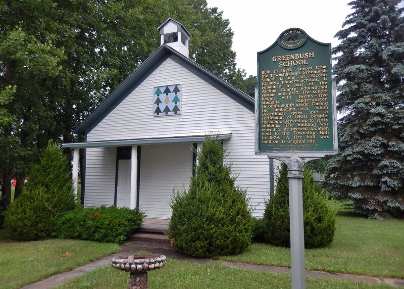
Built in 1870, across from the township hall, Greenbush School is one of Alcona County’s pioneer schools. It remained a part of the Alcona County educational system until 1947. The school began with twenty-five students, kindergarten through . . . — — Map (db m121967) HM
Circa 1845, William Hill established a fishery at this place,
which was called The Cove. He had five fishing boats and a
lodging house. The settlement became the village of Alcona.
In the 1860s and 1870s, Johnston, Haynes & Company built
a saw . . . — — Map (db m233580) HM
William Hill established a fishing
station in this area. known as "the
Cove." circa 1853. Early residents
were fishermen who netted the once
abundant schools of herring.
whitefish and perch. Johnson, Haynes
and Co. began lumbering the . . . — — Map (db m233566) HM
Le lac supérieur the French called it, meaning only that geographically it lay above Lake Huron. In size, however, Lake Superior stands above all other freshwater lakes in the world. The intrepid Frenchman Brulé discovered it around 1622. . . . — — Map (db m41968) HM
Swedish pioneer Charles Paulson purchased one hundred acres of land here in 1884 and constructed this cabin for his family home. Built of hand hewn cedar logs securely dovetailed at the corners, the house was occupied by Paulson and his wife until . . . — — Map (db m206179) HM
This area was logged in the late 1800's for the large white and red pine and white cedar. Then, in the 1930's and 40's the virgin hardwoods were logged. After the initial logging era, much of the land was tax delinquent and reverted to the State of . . . — — Map (db m226638) HM
Allegan County's name was coined by the noted student of the Indians, Henry Schoolcraft. The county was set off in 1831 and organized in 1835. Settlement of the county seat, Allegan, was promoted in 1835 by eastern capitalists who were attracted by . . . — — Map (db m69891) HM
Side 1
In 1866, faced with the growth of what were then the separate villages of Douglas and Dudleyville, Saugatauk Township Districts No. 3 and 4 merged forming Union District No. 3. The Douglas Union School opened for classes in . . . — — Map (db m45325) HM
Dutcher Lodge No. 193
Masons from Douglas, Fennville, and Saugatauk chartered Dutcher Lodge No. 193 on January 19, 1867. From 1867 to 1870 they held meetings in a building owned by Worshipful Master Thomas Dutcher. In 1875, the western . . . — — Map (db m45393) HM
Surveyed in 1839, the village of Pier Cove was once hailed as "the busiest port between St. Joseph and Muskegon." Before the Civil War, Pier Cove was a bustling community and a major point for lumber distribution, with ships departing daily carrying . . . — — Map (db m73498) HM
On its winding path to Lake Michigan, the Kalamazoo River separates the land of Saugatuck and Douglas. While the north bank pioneer settlements of Saugatuck and Singapore got their start in the 1830's, it was not until the 1850's that the opposite . . . — — Map (db m73643) HM
1825 - Trading post established by Louis Campau (a Frenchman) at the mouth of the Rabbit River approximately one mile upstream from what is now New Richmond.
1825 - Mack’s Landing trading post established where Purdy’s Landing is now . . . — — Map (db m73571) HM
New Richmond got its start in 1836, when three eastern investors, led by John Allen of Ann Arbor, arranged to found a city here. John Allen, a Virginian by birth, purchased 2240 acres in Allegan County on the north side of the Kalamazoo River just . . . — — Map (db m73573) HM
The early settlement that eventually became Fennville was established where two log roads crossed at a low place along the town line road between Manlius and Clyde Townships. Early maps show a church and sawmill on the high ground to the west of . . . — — Map (db m73526) HM
(Side One)
Erected in 1862, this church was the center of the Dutch immigrant community. The first settlers in this area arrived in early 1847 led by the Reverend Albertus C. V. Raalte. In June of that year a separate group of seventy . . . — — Map (db m73685) HM
The main portion of this building was the residence of George N. Smith, a Congregational missionary to the Indians in this area and at Waukazoo's Village on nearby Lake Macatawa. The mission was named after an Indian convert. Built in 1844-45 by . . . — — Map (db m73683) HM
In memory of the First Pioneers of Graafschaap of which the following are buried here
Lambert Tinholt 1849
Infant Neerken 1850
Geesje Kropschot 1850
Geert Kamps 1850
Roelafje Schrow 1850 . . . — — Map (db m73687) HM
Laketown Township was settled by Dutch immigrants who arrived in the area in 1847. Originally part of Newark Township, Laketown was set off in 1858 and named for its proximity to Lake Michigan. Officials did not have a meeting hall until 1884 when . . . — — Map (db m73641) HM
Jonathan Olin Round built the first log cabin in the area known as Hopkinsburg in 1837. His family came to join him in 1838. Other settlers soon followed. They settled in Hopkinsburg due to the good farmland the creek flowing through, providing . . . — — Map (db m74604) HM
On the 8th day of January, 1836, Mumford Eldred along with his second wife, Jane, and five children, settled on 40 acres in section 29 of Martin Township. The land included a 30 acre clearing on which the northern edge lived a small band of . . . — — Map (db m74657) HM
Settled in 1831 by the Hull Sherwood and Giles Scott families of Rochester, New York, the Pine Creek area was first called “New Rochester.” Allegan County’s first grist mill was constructed here in 1834, attracting customers from miles around, and . . . — — Map (db m74596) HM
Dr. Samuel Foster and his family built the first frame structure just west of here on the banks of the Kalamazoo River in the fall of 1831. First called “Allegan,” the name was changed officially to Otsego in 1835 when land developer Horace . . . — — Map (db m73761) HM
(Side One)
Overisel
Seeking religious liberty and better economic opportunity in a new land, the Reverend Seine Bolks and a congregation of about two dozen families, left Hellendoorn, Province of Overisel, The Netherlands, on . . . — — Map (db m73646) HM
Plainwell, formerly know as Plainfield, became an incorporated municipality in 1869, and later became designated as a city on March 12, 1934. The community is nestled along the banks of the Kalamazoo River and the Mill Race giving it the unique . . . — — Map (db m74530) HM
Chicago inventor and businessman Dorr Felt built this house as a summer home for his wife, Agnes. Felt held numerous patents, mostly notably for the Comptometer, the first machine to do complex calculations. In 1919 Felt purchased more than 750 . . . — — Map (db m73640) HM
Beneath the sands near the mouth of the Kalamazoo River lies the site of Singapore, one of Michigan's most famous ghost towns. Founded in the 1830's by New York land speculators, who hoped it would rival Chicago or Milwaukee as a lake port, . . . — — Map (db m45269) HM
You are near the center of Historic Saugatuck Township in River Bluff Park. The first settlers came here to a howling wilderness in the early 1830's. Within the township, Saugatuck is a half-mile to the west on the Old Allegan Road. Across the . . . — — Map (db m73604) HM
In the 1870's the Village of Shelbyville was created by the arrival of the Grand Rapids and Indiana Railroad. Shelbyville was named after the first railroad station agent, Mr. Shelby. Since there was already a Michigan town named Shelby, the . . . — — Map (db m74594) HM
It is hard to imagine now, but 200 years ago, the place we know as Wayland was densely forested and the people who lived here, the Match-E-Be-Nash-She-Wish Band of the Pottawatomi, lived in settled villages, farming, hunting, and gathering the rich . . . — — Map (db m73677) HM
In 1861 Bishop Frederic Baraga (1797-1868) trod through snow and icy waters from Sault Ste. Marie to Alpena where he founded a Catholic church. However, it was not until 1866 that Father Patrick Murray became the first resident pastor of the church . . . — — Map (db m121899) HM
In 1856 Daniel Carter, who came to
the Thunder Bay region seeking pine
lands, brought his wife, Sarah, and
daughter Mary to the town of Fremont,
present-day Alpena. They were Alpena’s
first permanent settlers. Daniel participated in the . . . — — Map (db m233610) HM
Before America was discovered, indigenous people hunted and fished the Grand Traverse region for thousands of years. As far back as 8,000 B.C., the waters of Grand Traverse Bay, Elk River and the 14 lakes of Antrim County's Chain of Lakes had been . . . — — Map (db m98175) HM
In 1856 Dexter and Noble Company began building an empire with their sawmill and mercantile business. In 1872 they built an iron smelting plant, one of the largest charcoal furnaces in the country. At each step of their building that empire, . . . — — Map (db m98125) HM
Native Americans have hunted and fished the Grand Traverse region for thousands of years, perhaps as many as 10,000 years before white settlers appeared. The waters of the Bay, Elk River and the 14 lakes of Antrim County's Chain of Lakes had been . . . — — Map (db m98128) HM
At the beginning of 1901, a
reporter visiting Essex noted thirty to forty houses, a
large sawmill. a stave factory, a shingle mill, one store,
a telephone office, a blacksmith shop, a livery stable
and a post office. A 1902
Central Lake Torch . . . — — Map (db m234152) HM
On November 10, 1881, the Antrim County Herald ran an advertisement about the village of Wetzell that read: "New Town, New Store; Everything New!" Earlier that year the Wetzell brothers had platted the village and opened a sawmill. As the . . . — — Map (db m215768) HM
This region's history is long and rich. Father Ménard, the Jesuit missionary, wintered near what is now L'Anse in 1660-1661. Near here Father Baraga set up his mission in 1843. He and the head of the neighboring Methodist mission, the Rev. J. . . . — — Map (db m76282) HM
Barry County, organized in 1839, was named after U.S. Postmaster General William Barry. Hastings, the county seat, was platted in 1836 and chartered as a village in 1855. The present courthouse was completed in 1892. A newspaper was published here . . . — — Map (db m150276) HM
In the early nineteenth century the Thornapple band of Ottawa Indians established a village a short distance from Thornapple Lake. It was served in the 1840s by a Methodist mission and school conducted by the Reverend Mannaseh Hickey. Trails leading . . . — — Map (db m191511) HM
Built in the 1880s by Daniel Striker, this Queen Anne-style building was once considered the "handsomest residence in Hastings." Born in New York State in 1835, Striker moved as a child with his family to Michigan. He was elected to several . . . — — Map (db m216572) HM
In 1850 George Thomas operated a sawmill here, and in the next decade as settlers began to arrive he built a gristmill. The new village, also known as Gull Lake, was a few miles south of the Reverend Leonard Slater’s Baptist Indian mission. Thomas . . . — — Map (db m191508) HM
Calvin G. (Squire) Hill, founder of the village of Middleville, came from New York state to Michigan in the autumn of 1834. He purchased four hundred acres on both banks of the Thornapple River where the village now stands. In 1854 he donated this . . . — — Map (db m216913) HM
Settlement began here in the mid-1830s, and in 1850 a post office known as Gun Lake was established. The village, never over 100 population, contained a sawmill, general store, blacksmith shop, and several other businesses. E. H. Bowen constructed . . . — — Map (db m216624) HM
Emory Parady was born in New York in 1844. On April 24, 1865, he was one of twenty-seven men from the 16th New York Cavalry Regiment who rode with the two detectives tracking John Wilkes Booth after the assassination of President Abraham Lincoln. On . . . — — Map (db m191499) HM
This plaque is issued by the Historical Society of Michigan in recognition of
Village of Nashville
Founded in 1869
For more than 150 years of continuous operation in service to the people of Michigan and for contributing to the growth and . . . — — Map (db m191542) HM
This village was settled in the mid-nineteenth century, and in 1857 a post office was opened. By 1860 a town of several blocks was established, and the businesses included a gristmill, hotel, and sash factory. The gristmill, run by Melatiah J. . . . — — Map (db m216525) HM
The area now known as Woodland Township was first settled in 1837 by Charles Galloway and Jonathan and Samuel Haight. In 1842, the state legislature set aside the township, which by then had several hundred residents. The area’s level surface and . . . — — Map (db m216646) HM
Center Avenue presents one of the most spectacular displays of late nineteenth and early twentieth century residential architecture in Michigan. Between 1870 and 1940 Bay City's prominent citizens favored Center Avenue as "the" place to live. Early . . . — — Map (db m33961) HM
Charles came to Bay City in 1864 from Ithaca, NY, to work for sawmill owners Henry Sage and John McGraw, eventually buying the Bay City Dredging Co. His home's architecture is Shavian Manorial, a Queen Anne/Tudor Revival style named after the . . . — — Map (db m33909) HM
Frankenlust
One of four colonies in Michigan settled by people from Franconia, Germany, Frankenlust was founded by Pastor Ferdinand Sievers and fourteen immigrants who established Saint Paul Evangelical Lutheran Church in June 1848. On July . . . — — Map (db m138097) HM
The Midland Street Commercial District comprises fifty buildings in a four-block area that was the business hub of West Bay City. Prior to 1830 the area was occupied by Sauk and Chippewa Indians. In response to depleted eastern timberlands resulting . . . — — Map (db m163221) HM
Spend some time wandering around Bay City and you'll notice a few names appearing time and time again...on buildings, streets and parks. Some identify the person responsible without a hint of their accomplishments. Others reflect the early . . . — — Map (db m182354) HM
Established in 1847, the Ogaukawning Indian Mission, the first church in present-day Bay County, served Chippewa Indians at the nearby Kawkawlin settlement. First ministered by Methodist missionaries, it soon came under Indian trusteeship and still . . . — — Map (db m182297) HM
Henry W. Sage (1814-1897) founded the village of Wenona (later West Bay City) in 1863. A merchant and philanthropist, he was also a founder of the Sage, McGraw and Company sawmill. In 1881 he donated property, building funds and $10,000 for books to . . . — — Map (db m163167) HM
During the 1870s, Swedish immigrants arrived in Bay County. By 1880 many Swedes had settled in West Bay City. In October of that year, fifty people organized the Swedish Evangelical Lutheran Sion Church, affiliated with the Augustana Synod. A year . . . — — Map (db m163096) HM
St. John Evangelical Lutheran German missionary Pastor Ferdinand Sievers organized St. John Church in June 1852 to serve a colony of German migrants, some fleeing the turmoil that followed the European revolutions of 1848. Initially, the church . . . — — Map (db m180379) HM
In 1858, in what was then a remote wilderness, the Rev. Charles E. Bailey and four families from his Ohio Congregational parish founded Benzonia colony. It was to be an "educational Christian colony" modeled after the earlier Congregational . . . — — Map (db m97478) HM
Dedicated to the memory of the pioneers, who, in 1858, came to this region, then an unbroken forest, to establish a Christian community and college. Here they founded the earliest institution of higher learning in northern Michigan which was a . . . — — Map (db m228944) HM
Thompsonville Junction
Constructed in 1889, Thompsonville Junction’s diamond crossing formed the intersection of the Chicago and Western Michigan Railroad (eventually the Chesapeake and Ohio) and the Frankfort and Southeastern Railroad . . . — — Map (db m228950) HM
(Obverse Side)
Israelite House of David
Based on the teachings of the Christian Israelite tradition begun by Joanna Southcott in England in 1792. Benjamin and Mary Purnell founded the House of David communal religious community in . . . — — Map (db m64809) HM
On April 13, 1836 Eleazar Morton (1786-1864) purchased land here for $1,000. Before long, he set aside a family cemetery plot. Other families asked to purchase adjacent plots. The cemetery grew, and in 1884, Eleazar’s son Henry C. and surveyor Ross . . . — — Map (db m184096) HM
Officially beginning on 14 March, 1930, Mary Purnell’s reorganization of the Israelite House of David began in a very humble fashion on newly acquired properties along Britain and Eastman Avenues. With four agricultural properties, an unfinished and . . . — — Map (db m81805) HM
This house built in 1849, by Eleazar Morton and his son Henry, was occupied until 1936 by four generations of Mortons. The oak-framed barn was built in 1840. Members of the Morton family, pioneers in this area, were prominent in Benton Harbor's . . . — — Map (db m43844) HM
Built in 1829 by Francis Murdock, the two story log cabin is the oldest home in Berrien County and of the five oldest homes still in existence in the state of Michigan. Murdock, a lawyer, was one of the first to argue a case in the new county . . . — — Map (db m226581) HM
Nearby French and English trading posts were known as parc aux vaches or “cowpens” for the wild buffalo once found here. Joseph Bertrand, an early trader, married the daughter of a Potawatomi chief and through her acquired land in . . . — — Map (db m1604) HM
Known as Parc aux Vaches, or “cow pasture,” this area was named by the French for the wild buffalo that once grazed here. Two major Indian trails crossed here: the Sauk Trail, also called the old Chicago Trail, which linked Detroit and . . . — — Map (db m64552) HM
People have lived on the terrace between Moccasin Bluff and the St. Joseph River for eight thousand years. The first inhabitants stayed in small temporary camps as early as 6300 B.C. The residents of A.D. 500 traded with groups in Indiana and . . . — — Map (db m217846) HM
Carl Sandburg
In 1926. author and poet Carl
Sandburg (1878 -1967) and his family
rented a summer home on Lake
Michigan, near the town of Sawyer.
Two years later, Sandburg purchased
several lots in Harbert. His wife Lilian
(1883-1977), . . . — — Map (db m165338) HM
The French fort built here in 1691 controlled southern Michigan’s principal Indian trade routes. Missionaries and fur traders were here already. The fort became a British outpost in 1761. Two years later it was one of the forts seized by Indians . . . — — Map (db m1628) HM
John Johnson Sr. donated property for this cemetery in 1838. His son Samuel had been buried on the land in 1835. John Johnson Jr. was among the township's first white settlers. The Johnsons and many pioneers are buried here. All but 20 of the 211 . . . — — Map (db m64953) HM
In 1854 Robert Hogue (1846-1905) migrated from Pennsylvania to Pipestone Township with his family. At age seventeen, he began teaching in a local school. He attended Adrian College, later graduating from the University of Michigan before he resumed . . . — — Map (db m64868) HM
Here in November 1679, on the Miami River, as the St. Joseph was then called, La Salle, the French explorer built a fort as a base for his western explorations. Here he awaited the Griffin, the upper lakes' first ship. When the ill-fated . . . — — Map (db m64837) HM
This Glacial Boulder found in the bed of the St. Joseph River was erected in 1902 by the Algonquin Chapter Daughters - American Revolution to commemorate the landing of Rene Robert Cavelier Sieur de La Salle and the building on this point. Fort . . . — — Map (db m43962) HM
During the late nineteenth and early twentieth centuries, local river captains, mill owners, merchants and other professionals built homes in this neighborhood. Over one hundred of their homes remain. They exemplify popular architectural styles . . . — — Map (db m64856) HM
Bronson was named after Jabez B. Bronson, who was
the first settler to the area, moving here from Ohio
in 1828. He became the first postmaster in 1830,
calling it Bronson's Prairie. It was Incorporated as a
village in 1866. The name was . . . — — Map (db m165471) HM
Allen Tibbets an itinerant Methodist minister
who preached the gospel for 15 years came to this
prairie in 1830 and purchased 80 acres in section 22
with the help of Joseph Hatchett who owned the adjoining
land in 1831 he plotted a village which . . . — — Map (db m165462) HM
The plat for the Village of Branch was signed the 16th day of March 1832 in Detroit by Sol. Sibley a Supreme Court judge for the Territory of Michigan. The proprietors Elisha Warren, De Gormo Jones, and Ebenezer S. Sibley also signed. . . . — — Map (db m66771) HM
(Obverse Side)
Branch County
Branch County, named for John Branch, President Andrew Jackson's secretary of the navy, was one of thirteen counties established by the Michigan Territorial Legislature in 1829. The village of Branch, . . . — — Map (db m66759) HM
On this site lived Cyrus Gray Luce, twenty-seventh Governor of Michigan. Born in Ohio in 1824, he moved to Branch County about 1849. He soon became involved in township, local and state politics, serving on the Board of Agriculture, in the . . . — — Map (db m66760) HM
Potawatomie Indians ceded Coldwater Prairie to the United States in 1827. The Indians called it “Chuck-sew-ya-bish,” meaning “cold spring water.” Coldwater is located at the junction of Old Sauk and Fort Wayne Indian trails. . . . — — Map (db m65858) HM
To Commemorate
the memory of
The Pioneers
and
First Surveyors
who by perilous efforts
over the Indian trail
made possible
the magnificent highway
M-23
Marked by
The Coldwater Chapter
Daughters of American . . . — — Map (db m241051) HM
At this point the Coldwater and St. Joe Rivers join, creating their namesake “Union” City. In the late 1820s a road surveying party following the Washtenaw Indian Trail that later became M-60 stumbled upon this junction and returned giving a . . . — — Map (db m95217) HM
Union City's own “Daniel Boone,” Austin “Skinny” Bullock (1908-77), moved into this, his beloved Elkhorn Lodge, on the first day of
summer in 1952. He was a colorful
local legend who loved to hunt, trap and fish, earning his living by . . . — — Map (db m95241) HM
Long before European settlement and Union City, the St. Joe was known by Native Americans as the River of the Miamis. It was an important resource for water, game, fish and transportation. The origin of the St. Joe is found in the lake in Hillsdale . . . — — Map (db m95242) HM
In 1904 the Albion Malleable Iron Company began recruiting workers for its foundry. The arrival of six Russians from New York City marked the beginning of Albion's "Foreign Colony." By 1915 the Foreign Colony had grown to around 600 people of . . . — — Map (db m177134) HM
The first house at what was then known as the "Forks of the Kalamazoo" was erected near this site by Tenney Peabody, a New Yorker. To this cabin with its thatched roof of grass from the banks of the nearby Kalamazoo River, Albion's first settler . . . — — Map (db m27815) HM
This tablet,
erected by the citizens
of
Battle Creek
in connection with
the Centennial Celebration,
1931,
marks the place
on which was builded, [sic]
in 1831,
the first dwelling
in
Battle . . . — — Map (db m177457) HM
This country schoolhouse, one of a vanishing type, was built in 1859 and named after Ira Beckley, an early settler. During the first year, thirty-three pupils used a library of forty-two books for a seven-month session. Instruction was offered in . . . — — Map (db m190180) HM
This farm has remained in the Bryant family since 1844 and retains much of its original Civil War era appearance. The ruins of stone fences erected without mortar still stand as a rare reminder of early settlement. Mary Bryant Mayo (1845-1903), . . . — — Map (db m178045) HM
This site on Territorial Road was a gift of Seeley Neal (1778-1862) from 640 acres acquired from the government in 1831. Neal, a veteran of the War of 1812, built the first log house in the township. His was the first family to locate in the . . . — — Map (db m226150) HM
This stone marks the
"Old Territorial Road"
one of the two trails over which
emigration came into Michigan
Mary Marshall Chapter, D.A.R.
dedicates it to the
pioneer men and women
of Calhoun County — — Map (db m216537) HM
Chauncey M. Brewer immigrated
from upstate New York in 1836 at
the age of 21 years. He was elected
Marshall's first Treasurer in 1838 and
by occupation was a prosperous
dry goods merchant with associates
which included his sons, C.D. and . . . — — Map (db m190086) HM
Gorham (1812-1901) came to Marshall in 1836 from New York State. First a merchant, he became a banker and in 1865 organized the First National Bank of Marshall, now the Michigan National Bank. He was a defendant in the famous Crosswhite fugitive . . . — — Map (db m225807) HM
Isaac E. Crary (1804-1854) was a young
Connecticut lawyer who came to Marshall
in 1834 and was Michigan's first member
of the U.S. House of Representatives at
the time of statehood in 1837. In 1835
he teamed with Rev. John D. Pierce . . . — — Map (db m190362) HM
Charles T. Gorham (1812-1901) came to Marshall with Chauncey Brewer and opened the Eagle Store in 1836. A native of Danbury, Connecticut, he opened Gorham's Exchange Bank in 1840. He was convicted for aiding escaped slave Adam Crosswhite and his . . . — — Map (db m190363) HM
State Senator James Wright Gordon built this Greek Revival house in 1839, the year he introduced a bill to make his town state capital. Land near his house had been selected for the capitol grounds. Marshall’s hopes were not fulfilled but Gordon . . . — — Map (db m177157) HM
Randall Hobart arrived in Marshall
in 1831 as a lay preacher who helped
organize the local Methodist Church.
He served as the Justice, who delayed
the Kentucky slave hunters long
enough to allow the Adam Crosswhite
family to escape to Ontario . . . — — Map (db m189341) HM
977 entries matched your criteria. The first 100 are listed above. Next 100 ⊳