Near North Carolina Route 62 near Kimesville Road (County Route 1113), on the right when traveling west.
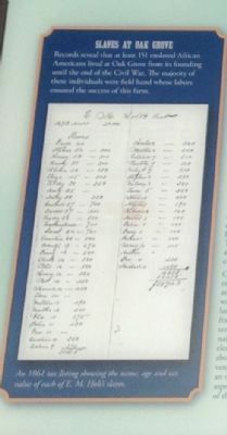
Oak Grove (ca. 1790-1910) was a 1,693-acre grain farm owned by the Holt family. The Holts were pioneers in the southern textile industry and developers of "Alamance Plaid" fabrics. While textiles made the Holts one of the wealthiest families in . . . — — Map (db m222727) HM
Near North Carolina Route 62 at Kimesville Road (County Route 1113), on the right when traveling west.
1693 acre grain plantation founded by Michael Holt III (1778-1842). Birthplace of E.M. Holt (1807-1884), a founder of the southern textile industry and developer of "Alamance Plaid" fabrics. Dr. William Rainey Holt (1798-1868), noted "scientific . . . — — Map (db m222728) HM
On Bellemont-Alamance Road, on the left when traveling east.
On Colonial Trading Path
Travelers used nearby spring
Preaching point 1759
Originally called "Graves Church"
Church founded circa 1770
Burials from early period in
rock enclosed cemetery
Recorded burials from 1790
Called "the Chappel" . . . — — Map (db m222798) HM
Near North Carolina Route 62, 0.2 miles south of Oakbury Road, on the right when traveling south.
Quaker John Allen constructed this log dwelling circa 1780 in nearby Snow Camp. The State of North Carolina moved it here in 1966, restored it, and opened it to the public in 1967 to illustrate colonial life in the backcountry of North Carolina. The . . . — — Map (db m42253) HM
On North Carolina 62, 0.1 miles south of Pond Road, on the right when traveling south.
Colonial trading route, dating from 17th century, from Petersburg, Virginia, to Catawba and Waxhaw Indians in Carolina, passed nearby. — — Map (db m222808) HM
Near R Dean Coleman Road, 1 mile north of Friendship Patterson Mill Road.
It took John and Polly Garrett five years to build this house. During that five year period, they lived in the small log home to your right. The Garrett's moved into this house in 1835. Four years later, Polly gave birth to their first child. They . . . — — Map (db m222784) HM
Near R Dean Coleman Road, 1 mile north of Friendship Patterson Mill Road.
In 1830, John and Polly Garrett constructed this small log home, which is one of the earliest structures in the district. They lived in this house for five years while they were building the large two-story house behind you. This house served as a . . . — — Map (db m222788) HM
Near R Dean Coleman Road, 1 mile north of Friendship Patterson Mill Road.
During the 1870's and 80's, this building served as a community post office. The building has been restored and displays "pigeon holes" which are compartments used to sort the mail.
The building on the right is a smoke house. It dates back to . . . — — Map (db m222794) HM
Near R Dean Coleman Road, 1 mile north of Friendship Patterson Mill Road.
The animals of a turn of the century farm were very important to the self supporting farmer. We have tried to represent some of the more common animals found on the farm. We presently have sheep, goats, beef cows, dairy cows and a team of mules. The . . . — — Map (db m222800) HM
Near R Dean Coleman Road, 1 mile north of Friendship Patterson Mill Road.
The corn crib (located on your left) was a special building used for storing corn and other grains. The corn would be picked from the fields and put in there to dry. Once the corn dried, the farmer would separate the kernels from the cob using a . . . — — Map (db m222803) HM
On Glencoe Street, on the left when traveling west.
2. Picker House
After drivers delivered bales of raw cotton to Glencoe, the first step in transforming it to woven cloth took place in the Picker House. Men unpacked the cotton from the bales and removed such debris as twigs, leaves, and bugs. . . . — — Map (db m222789) HM
On Glencoe Street, on the left when traveling west.
African Americans experienced the textile mill world very differently than white families. Mills did not offer the same work opportunities to black men and women as they did for whites. Life in the mill village was also restricted, and black workers . . . — — Map (db m222732) HM
On Glencoe Street, on the left when traveling west.
Mill owners initially built villages near textile mills to attract families of workers. By 1900, 92% of workers lived in mill-owned housing. A typical mill village in the 1920s consisted of about 350 houses located within walking distance of the . . . — — Map (db m222743) HM
On Glencoe Street, on the left when traveling west.
Early textile mill owners alleviated labor shortages by recruiting entire families for employment. Offering homes as well as jobs, owners created villages of workers from which the mills could draw. Children - sometimes as young as seven - filled . . . — — Map (db m222745) HM
On Glencoe Street, on the left when traveling north.
Church congregations were central to social as well as religious life in the village. Mill owners encouraged church membership among their workers and often aided congregations to promote social stability and community morality. The Baptist church, . . . — — Map (db m222747) HM
On Glencoe Street, on the left when traveling west.
Although industrialization brought great improvements to the South, advancements in health and medicine lagged dramatically behind. Without antibiotics, infectious diseases were common and dangerous. Medical care was often unavailable, and employers . . . — — Map (db m222752) HM
On Glencoe Street, on the right when traveling west.
The whole matter of providing attractive and comfortable habitations for cotton operatives [is] summarized in the statement that they are essentially a rural people…while their condition is in most cases decidedly bettered by going to the . . . — — Map (db m222763) HM
On Sarah Rhyne Road, on the right when traveling west.
In 1899 James H. Holt sold Emanual "Man" Marshall a one-acre lot at the northeastern end of the Glencoe property. "Man" Marshall was the superintendent at Glencoe Mills for nearly forty years. He and wife Mary Eliza Murray Marshall lived with their . . . — — Map (db m222765) HM
On Sarah Rhyne Road, on the right when traveling west.
When Glencoe Mill opened in 1880, founder James H. Holt was ahead of most of his contemporaries in requiring that village children attend school for several months a year to the sixth grade, before they could work in the factory. The company built . . . — — Map (db m222767) HM
In Glencoe as in other Alamance County villages, the Holts built many substantial, 2-story houses for the workers. They resembled farmhouses in the area. In most of the 2-story houses, carpenters used hand-sawn timbers put together with pegs. Some . . . — — Map (db m222768) HM
At Glencoe, there were three levels of management: Owner, Manager, and Superintendent. The location and style of their houses indicated their occupants' status in the hierarchy. The Mill Owner's House, built for Robert Holt, is a large 2-story . . . — — Map (db m222769) HM
On Glencoe Street, on the right when traveling west.
Incorporated in 1880 by James H. and William E. Holt, sons of textile pioneer E. M. Holt. The last water-powered textile mill developed by the Holts. Produced napped cotton cloth, flannels and woven plaids. Employed as many as 500 workers at its . . . — — Map (db m222770) HM
A remarkably complete mill village exemplifying the post-Civil War development of the textile industry along the streams of piedmont North Carolina. Glencoe Mill built nearly 50 houses for its workers. Acquired by Preservation North Carolina in 1997 . . . — — Map (db m222771) HM
On Glencoe Street, on the left when traveling west.
In the village, every aspect of the workers’ lives revolved around the mill. In addition to their homes, the churches, schools, and stores all belonged or were tied to the mill owners. While these places provided much needed social time for mill . . . — — Map (db m222773) HM
On Glencoe Street, on the right when traveling north.
The Lodge Hall, a small frame building, housed many types of gatherings. The Barber Shop, built in the 20th century, served village men and boys. In one period, old-timers recall, a barber would arrive and open the shop to cut hair one evening each . . . — — Map (db m222775) HM
On Glencoe Street, on the left when traveling west.
Transitioning from the farm to an industrialized way of life was especially hard for men. On the farm, men experienced a certain amount of freedom and variety; millwork was often tedious, repetitive, and produced only wages for a day's labor. Men . . . — — Map (db m222776) HM
On Glencoe Street, on the left when traveling west.
Industrialization came to the South later than it had in the North. The first generation of mill workers were transplanted farmers who had no tradition of labor unions. The nature of the mill village also made organized labor difficult. The mill . . . — — Map (db m222787) HM
On Glencoe Street, on the left when traveling west.
Mill designers planned the brick and heavy timber mill to standards of the day. They employed the Italianate style popular for industrial architecture. Its ornate brickwork, arched windows, low roof, and prominate tower suited the functional needs . . . — — Map (db m222804) HM
On Glencoe Street, on the left when traveling west.
The first waves of migration off the farms were primarily single women and widows. Since these women had limited access to land, they were eager to take the steady work and housing the textile mills provided. An example of this was Bynum, North . . . — — Map (db m222806) HM
On North Main Street, on the right when traveling north.
Side A Providence was a gathering spot for pioneers in the Haw River basin. Many families and denominations during the eighteenth century used this cemetery. Many early settlers including members of the Turrentine, Sellars, Holt, Harden, . . . — — Map (db m28277) HM
On East Center Street at N. 7th Street, on the right when traveling east on East Center Street.
Colonial trading route, dating from 17th century, from Petersburg, Virginia, to the Catawba and Waxhaw Indians in Carolina, passed nearby. — — Map (db m223046) HM
Near Church Road, 0.1 miles south of Sissipahaw Way, on the left when traveling south.
Saxapahaw was first settled by the Sissapahaw Indians - a hunting and farming tribe. In 1701, explorer and surveyor John Lawson visited the area and described it as "the flower of the Carolinas". In the mid-1700s, the first European settlers came . . . — — Map (db m215840) HM
On Snow Camp Road, 0.2 miles south of Greensboro-Chapel Hill Road.
Settled by Quakers in 1749. Cornwallis camped in area after Battle of Guilford Courthouse and used home of Simon Dixon as headquarters. — — Map (db m223102) HM
On Blue Ridge Parkway, 7 miles east of State Highway 18, on the right when traveling east.
You are looking into Basin Creek Cove. The log cabin 1500 feet below was the home of Martin and Janie Caudill and their 14 children. Martin's father, Harrison, who fathered 22 children, lived about a mile down the creek in the community of Basin . . . — — Map (db m162088) HM
On Blue Ridge Parkway (at milepost 236.9), on the right when traveling south.
For thousands of years Native Americans cultivated the fertile valleys of the Blue Ridge region including North Carolina. Employing techniques such as “slash and burn” to clear small areas of forested land and fertilize the soil, the . . . — — Map (db m123230) HM
On U.S. 52 at Old Sneedsboro Road (North Carolina Highway 1829), on the right when traveling south on U.S. 52.
Laid out 1795. Promoted as inland port town on Pee Dee River by Archibald D. Murphey. Only graveyard remains, five miles southeast. — — Map (db m42309) HM
On Rugby Road (State Highway 194) at Joe Thomas Road, on the left when traveling north on Rugby Road.
North Carolina. Colonized, 1585-87, by first English settlers in America; permanently settled c. 1650; first to vote readiness for independence, Apr. 12, 1776
Virginia. First permanent English colony in America, 1607, one of thirteen . . . — — Map (db m95737) HM
On Railroad Grade Road (State Road 1100) at South Fork Church Road, on the right when traveling south on Railroad Grade Road.
The early history of Todd is much like that of numerous crossroads communities
throughout northwestern North Carolina. Located where Elk Creek flows into the
South Fork of the New River, it was a logical site for trade, starting with . . . — — Map (db m228892) HM
On Carteret Street (County Road 99 / 92) at South Main Street, on the left on Carteret Street.
Bath, originally the Indian town of
Pampticough, was settled by white men
about 1690 and incorporated in 1705.
It is the oldest town in North Carolina.
Its first commissioners were John Lawson,
Joel Martin, and Simon Alderson. Here was . . . — — Map (db m64799) HM
Near Carteret Street (State Highway 92) at Harding Street.
Bath, oldest town in North Carolina, was established in 1705. The first settlers were French Huguenots from Virginia. Among the early English inhabitants were John Lawson, author of the first history of Carolina (1709) and Christopher Gale, Chief . . . — — Map (db m67574) HM
Near Carteret Street (State Highway 92) at Harding Street.
Bath, the oldest incorporated town in North Carolina, was established in 1705. By the 1708 the town consisted of twelve houses and a population of fifty people. Among the early inhabitants were John Lawson, Surveyor General of the colony and . . . — — Map (db m67575) HM
On South Main Street near Carteret Street (County Road 99), on the left when traveling south.
Colonial home of Colonel Robert Palmer, Surveyor-General of North Carolina 1753-1771 and Collector of Customs for the Port of Bath. Built c. 1744, probably by Michael Coutanche, it is one of the oldest surviving dwelling-houses in the State. . . . — — Map (db m66701) HM
On Cateret Street (North Carolina Route 92) at North Main Street, on the right when traveling west on Cateret Street.
1704-John Lawson surveyed 1st 71 lots in Bath.
1710-Thomas Harding, first recorded shipbuilder in Colony, contracted by Gov. Thomas Cary, to build sloop in Pamlico area.
1715-Harding named Town Commissioner & Vestryman. He owned Lots 27-28 at . . . — — Map (db m226318) HM
On North Bonner Street at East Main Street, on the right when traveling north on North Bonner Street.
Washington's original "free" church, open to all denominations, was constructed on lot 50 of the town's plat, created by Col. James Bonner, the founder of Washington, circa 1776. Bonner and two other Revolutionary War soldiers are buried here. . . . — — Map (db m226315) HM
On West Stewart Parkway at South Respess Street, on the right when traveling east on West Stewart Parkway.
The Original Washington
The history of Washington began around 1585 when English explorers first visited the area that would become Washington. The easily navigable waters and excess of natural resources made the area a very successful port . . . — — Map (db m226611) HM
On East Water Street at South Bonner Street, on the right when traveling east on East Water Street.
To commemorate
the 200th Anniversary of
Washington, North Carolina
The first town
in the United States
to be named for
General George Washington
Originally known
as "town at the forks of the
Tar River." It was settled . . . — — Map (db m70505) HM
On Cypress Road at Governor Eden House Road, on the left when traveling east on Cypress Road.
Along the banks of the Chowan River and Salmon Creek, the seeds were planted for the colony and state of North Carolina. From these roots in the 1600s emerged the refined plantation life of the ruling colonial gentry in the 1700s, made possible by . . . — — Map (db m56927) HM
On South King Street at East Water Street (U.S. 17), on the right when traveling north on South King Street.
William Gray in 1776 set aside 100 acres at Gray’s Landing for establishing a town. 18th century travelers would have disembarked from sailing vessels docked at the foot of King Street at the old Gray’s Landing site. Visitors to Windsor today, . . . — — Map (db m60629) HM
On South King Street at East Water Street (U.S. 17) on South King Street.
Created by an act of Colonial Assembly in 1768, New Windsor was established on the site known as Gray’s Landing. A part of grants to the Lords Proprietors, 2800 acres on the Cashie River were sold in 1717 by John Lord Carteret, Earl of Granville to . . . — — Map (db m60630) HM
On U.S. 17, 0.4 miles south of Boundaryline Drive NW, on the right when traveling north.
South Carolina. Formed in 1712 from part of Carolina, which was chartered in 1663, it was first settled by the English in 1670. One of the 13 original states.
North Carolina. Colonized, 1585-87, b first English settlers in America; . . . — — Map (db m39649) HM
On Main Street (Business U.S. 17) south of Mulberry Street, on the right when traveling north.
Established late 1700’s. Incorporated March6, 1899. The Shallotte River was navigated by commercial sailing vessels until the 1920’s when the roads were built. First church building erected on this site circa 1799. — — Map (db m28823) HM
On Ferry Road (State Highway 211) at the Deep Point Marina exit road, on the left when traveling east on Ferry Road.
Barbadian planter turned pirate made North Carolina his base, 1718. Captured in naval battle few miles east. Hanged in Charleston. — — Map (db m101979) HM
On Plantation Road, 0.1 miles east of River Road (Route 133), on the left when traveling south.
House built c. 1725, subsequent additions. Home first of Roger Moore, later of Gov. Benjamin Smith, still later of James Sprunt. ¾ mi. E. — — Map (db m167688) HM
Dedicated to the memory of
Samuel Ashe
1725 - 1813
Distinguished North Carolinian
Governor, Statesman and Jurist
in whose honor
the City of Asheville was named
— — Map (db m30120) HM
On North Pack Square (Alternate U.S. 74) at Broadway (U.S. 25), on the left when traveling east on North Pack Square.
Native American trails guided settlers to this site, where in 1793 the Buncombe County Court placed the first courthouse, prison, and stocks. With the opening of the Buncombe Turnpike in 1827, this public square became a crossroads for stagecoach . . . — — Map (db m97553) HM
On Hendersonville Road, on the right when traveling south.
The expedition led by Gen. Griffith Rutherford against the Cherokee, September, 1776, passed nearby on the banks of the Swannanoa River. — — Map (db m2279) HM
On South Pack Square (Alternate U.S. 74) east of Biltmore Avenue (U.S. 25), on the right when traveling east.
Buncombe County was carved out of a magnificent mountain landscape etched by indigenous trails and scattered settlements. The bill creating the county was ratified on January 14, 1792.
In 1793, the county's first official courthouse, a jail and . . . — — Map (db m98370) HM
On Blue Ridge Parkway (at milepost 394) at North Carolina Highway 191, on the right when traveling north on Blue Ridge Parkway.
The French Broad River played a major role in this region’s early development. Initially called the “Broad River” by eighteenth-century French hunters and traders, it was later named the French Broad River. With headwaters on Pisgah . . . — — Map (db m58937) HM
On Sutton Avenue just east of Cherry Street, on the right when traveling east.
You Have Arrived
The Swannanoa River Valley was known as "Grey Eagle" in the time when the Cherokee and Catawba people lived here. By the late 1800s, surveyors had deemed the neighboring Black Mountains range the highest in the Eastern . . . — — Map (db m209919) HM
On Sutton Avenue, on the left when traveling west.
This community was incorporated n March 4, 1893 as the town of Black Mountain with its limits measuring one mile from this point. In 1993, the town's Centennial Commission dedicated this monument to the following first century families.
Marcus . . . — — Map (db m209915) HM
On Sand Hill Road (State Highway 3412), on the right when traveling north.
Here on land granted him in 1787.
He erected the first house of white
settlers west of the Blue Ridge.
Capt. Moore and his troops camped near
here when on the Rutherford Expedition
against the Cherokee in 1776.
Erected by Unaka . . . — — Map (db m56431) HM
On East Union Street (Business U.S. 70) at Lenoir Street, on the right when traveling south on East Union Street.
Hero of the Battle of Cowpens during the American Revolution. Burke County Patriot Militia fought alongside Morgan, a Virginian. In 1784 the Town of Morgansborough was established in his honor. The name was changed to Morganton in 1838. — — Map (db m187663) HM
To the Waldensian Colony
from the Cottian Alps.
who settled here first
in 1893
numbering in all 427,
in recognition of their
Christian ideals, integrity, industry and good citizenship
this monument is erected,
by the Town of Valdese.
And . . . — — Map (db m20336) HM
First Marker:Centennial Seal
Official Seal of the 100th
Celebration of the founding
of Valdese
Future
From an agrarian beginning
through Industrial growth,
comes a bright horizon
Civic
Citizens Band together . . . — — Map (db m20396) HM
On Rodoret Street South at Janavel Avenue Southwest, on the right when traveling south on Rodoret Street South.
Liberty, Faith and Honor. The Waldenses, dating from at least the 12th century, were a persecuted people who survived plagues, exiles into barren lands and the edicts of rulers calling for their extinction. These faithful people wanted to read the . . . — — Map (db m210391) HM
On Union Street S just south of Cabarrus Avenue West (County Road 1002), on the right when traveling south.
Catawba Indians originally inhabited present day Cabarrus County when significant numbers of Dutch, Scots-Irish, German, and Welsh-English families began traveling the Great Wagon Road to North Carolina backcountry in the middle of the eighteenth . . . — — Map (db m175769) HM
On Union Street South just north of Means Avenue Southeast, on the right when traveling south.
Red Hill Tavern was home to Martin Pheifer, Jr. Mr. Pheifer was a good friend of George Washington, having served with him at Valley Forge. For that reason President Washington was a private guest of Pheifer during his Southern Tour, dining and . . . — — Map (db m175756) HM
On U.S. 70 west of Horsehoe Road, on the right when traveling west.
Davis was first settled by four families in the early 1700s. Though the main occupations were a combination of farming and fishing its fame was its waterfowl legacy.
Waterfowl meat was in demand in urban America and supplied by market hunters. . . . — — Map (db m226096) HM
Believe it or not, Portsmouth, the small, now-deserted village on this remote island, was once a bustling seaport. North Carolina's colonial legislature chartered Portsmouth in 1733 to serve coastal trade, and for more than two years it was one of . . . — — Map (db m177229) HM
Completed in 1915 this church was the spiritual and communal center of the island, and like the villagers themselves it weathered many storms. As you enter the building notice that it tilts slightly to the right. The hurricane of 1944 left it this . . . — — Map (db m177424) HM
In the 1900s this building served as general store and post office. Portsmouth villagers called it the "new" store because it was the latest in a series of stores serving the community. At one time in the 1860s there were five. This store was built . . . — — Map (db m177276) HM
On U.S. 70 at Otway Farm Road, on the right when traveling east on U.S. 70.
Otway’s first residents migrated northward from the Straits area in the 1700s. The rich farmland and access to water teeming with fish, crabs, and oysters made it desirable for homesteading.
A 1932 Beaufort newspaper recounts a fall ritual . . . — — Map (db m212875) HM
On U.S. 70 north of Emilee Lane, on the left when traveling south.
The first deeded property was in 1752 to William Salter. The early settlers called this area, Piney Point, for the piece of wooded land which jutted out into Core Sound and served as a navigational day mark. With the establishment of the post office . . . — — Map (db m212872) HM
On U.S. 70 north of Donnie Davis Road, on the right when traveling south.
Williston’s first settlers came in 1723. Life was self-sustaining with no large industry until 200 years later when the Willis Brothers Seafood Company was formed. This clam, scallop and fish house became the main employer for Williston and . . . — — Map (db m212874) HM
On Broad Street (State Highway 57) just east of Palmers Alley, on the right when traveling east.
Built for Jarvis Friou a French Huguenot and prominent businessman. A Federal style house with an added Victorian style ornate bracketed porch. Original to the house is the beautiful red Venetian glass transom and interior woodwork attributed to . . . — — Map (db m220874) HM
On Academy Street (State Highway 62) just south of Broad Street (State Highway 62), on the right when traveling south.
Queen Anne and Victorian style home built by David Patterson, a dry goods merchant from Ireland. Later home and office of noted physicians Dr. Charles Dodson and son, Dr. Henry Dodson who together provided medical care to the community from mid to . . . — — Map (db m171784) HM
On North Main Street (State Road 10) north of 1st Avenue Northwest, on the left when traveling north.
Depot built here at siding on Western North Carolina Railroad, 1859; village organized as Catawba Station, 1872; market center for locally produced tobacco and flour; incorporated as Town of Catawba in 1893; base for building nearby Lookout Shoals . . . — — Map (db m210418) HM
Commemorating the memory of Henry Weidner Robinson
This marks the town of Hickory Tavern as incorporated December 12, 1863. The city of Hickory Commemorates Henry Weidner Robinson who in 1859 gave this site as a public common. The citizens of . . . — — Map (db m18544) HM
To the rear of this spot stood a log house known in 1799 as Hickory Tavern. This tract of 640 acres was surveyed by Col. Christopher W. Beekman on June 8, 1779 and was granted to William McMullen Oct. 28, 1783 on the south side of this tavern ran . . . — — Map (db m18538) HM
On Bryant Jones Drive at North Carolina Highway 16, on the right when traveling west on Bryant Jones Drive.
Drumsville business district was concentrated primarily on the northeast side
of the base of Little Mountain near Mountain Creek and the T-Junction of roads
known today as Mathis Church Road at Little Mountain Road. That's a distance
of about . . . — — Map (db m240774) HM
Near Greenway Avenue north of Windy Holly Lane when traveling north.
Built in 1834, two congregations shared the log-built Haas Church:
Reformed Presbyterian and Lutheran. These different faiths shared
a worship space because building materials were costly and families
couldn't afford time away from their farms. . . . — — Map (db m240703) HM
On East 3rd Street (County Road 1107) at North 2nd Avenue, on the left when traveling east on East 3rd Street.
Place first known as Matthews Crossroads, a rural post office named Energy opened here in 1880. The coming of the railroad in 1884 stimulated the development of a town, first known as Siler Station. Population in 1890 was 254.
Above is the . . . — — Map (db m171996) HM
On Siler City Snow Camp Road, 0.4 miles north of Edwards Road, on the right when traveling north.
The first Siler to settle in this area. He came from Germany to America in 1738 and moved here about 1760. He built a grist mill just east of the present bridge over Rocky River. He furnished supplies during the Revolutionary War and was declared a . . . — — Map (db m233317) HM
On Locust Street at County Highway 1419, on the left when traveling north on Locust Street.
Welcome to Konehete, the Long Valley Place that white’s shortened to Valleytown, the first name of Andrews. For centuries, the Long Valley was home to Cherokee communities such as Little Tellico, Tomatla, Conostee, Quotoconechito, Nehowee, Dasetsi, . . . — — Map (db m156076) HM
On U.S. 19, 3.8 miles south of U.S. 64, on the left when traveling south. Reported missing.
North Carolina. Colonized, 1585-87, by first English settlers in America; permanently settled c. 1650; first to vote readiness for independence, Apr. 12, 1776.
Georgia. The colony of Georgia was chartered in 1732, named for King George . . . — — Map (db m25333) HM
Near Peachtree Street at Alpine Street, on the right when traveling north.
Cherokee Heritage Trails (Tsalagi Usdi Nvnohi) wind through the mountains of North Carolina, Tennessee, and Georgia, in the heart of Cherokee homelands that once encompassed more than 140,000 square miles. Here, where Cherokee people have lived . . . — — Map (db m134947) HM
491 entries matched your criteria. The first 100 are listed above. Next 100 ⊳